Country:
 Canada
Region:
City:
Latitude and Longitude:
Time Zone:
Postal Code:
IP information under different IP Channel
ip-api
Country
Region
City
ASN
Time Zone
ISP
Blacklist
Proxy
Latitude
Longitude
Postal
Route
IPinfo
Country
Region
City
ASN
Time Zone
ISP
Blacklist
Proxy
Latitude
Longitude
Postal
Route
MaxMind
Country
Region
City
ASN
Time Zone
ISP
Blacklist
Proxy
Latitude
Longitude
Postal
Route
Luminati
Country
CARegion
ab
City
calgary
ASN
Time Zone
America/Edmonton
ISP
ASN-WIBAND-1
Latitude
Longitude
Postal
db-ip
Country
Region
City
ASN
Time Zone
ISP
Blacklist
Proxy
Latitude
Longitude
Postal
Route
ipdata
Country
Region
City
ASN
Time Zone
ISP
Blacklist
Proxy
Latitude
Longitude
Postal
Route
Popular places and events near this IP address
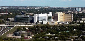
Foothills Medical Centre
Hospital in Alberta, Canada
Distance: Approx. 1393 meters
Latitude and longitude: 51.065389,-114.133306
Foothills Medical Centre (FMC) is the largest hospital in the province of Alberta and is located in the city of Calgary. It is one of Canada's most recognized medical facilities and one of the leading research and teaching hospitals. Foothills Medical Centre provides advanced healthcare services to over two million people from Calgary, and surrounding regions including southern Alberta, southeastern British Columbia, and southern Saskatchewan.
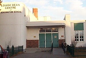
Louise Dean School
Public (canada) school in Calgary, Alberta, Canada
Distance: Approx. 1450 meters
Latitude and longitude: 51.0525,-114.1154
Louise Dean School is a public combined junior and senior high school in Calgary, Alberta, Canada, that teaches Grades 9 through 12. It is designed exclusively for teenage mothers, both current and expectant. It is operated by the Calgary Board of Education (CBE) with assistance from The Catholic Family Service of Calgary; despite the organization's name, the program is secular.
Parkdale, Calgary
Neighbourhood in Calgary, Alberta, Canada
Distance: Approx. 679 meters
Latitude and longitude: 51.05888889,-114.13861111
Parkdale is a mature, inner city neighbourhood in the city of Calgary, Alberta along the north bank of the Bow River between the communities of West Hillhurst and Point McKay. It is bounded on the south by the Bow River, 28 St NW to the east, Shaganappi Trail NW to the west and on the north by 16th Avenue. Parkdale is in close proximity to both the Foothills Medical Centre and the Alberta Children's Hospital constructed in 2006, as well as the University of Calgary.
Cumming School of Medicine
Medical school in Alberta, Canada
Distance: Approx. 1433 meters
Latitude and longitude: 51.06583333,-114.13444444
The Cumming School of Medicine (previously Faculty of Medicine) is the medical school of the University of Calgary. It was established in 1967 and adopted its current name in 2014. It is one of two medical schools in Alberta and one of 17 in Canada.
Wildwood, Calgary
Neighbourhood in Calgary, Alberta, Canada
Distance: Approx. 1038 meters
Latitude and longitude: 51.05194444,-114.15083333
Wildwood is an established neighbourhood in the Southwest quadrant of Calgary, Alberta. It was first settled in 1883 and developed in the 1950s on a plateau to the south to the Bow River valley, and is primarily composed of single-detached bungalows on wide lots with rear laneways. Wildwood is bounded on the north by Edworthy Park, a significant natural area park in Calgary, and the Bow River.
St. Andrews Heights, Calgary
Neighbourhood in Calgary, Alberta, Canada
Distance: Approx. 881 meters
Latitude and longitude: 51.05972222,-114.12944444
St. Andrews Heights is a residential neighbourhood in the northwest quadrant of Calgary, Alberta. It is bounded to the north by the Trans-Canada Highway, to the east by Crowchild Trail, to the south by Toronto Crescent, and to the west by 29 Street.
Spruce Cliff, Calgary
Neighbourhood in Calgary, Alberta, Canada
Distance: Approx. 359 meters
Latitude and longitude: 51.05055556,-114.13944444
Spruce Cliff is a residential neighbourhood in the southwest quadrant of Calgary, Alberta. It is bounded to the north by the CPR tracks and the Bow River, to the east by the Shaganappi golf course and 33 Street W, to the south by Bow Trail and to the west by 38 Street W. The land was annexed in 1910, and Spruce Cliff was established in 1950. It is represented in the Calgary City Council by the Ward 6 councillor.
Point Mckay, Calgary
Neighbourhood in Calgary, Alberta, Canada
Distance: Approx. 949 meters
Latitude and longitude: 51.05972222,-114.14444444
Point Mckay is a residential neighbourhood in the northwest quadrant of Calgary, Alberta. It is bounded to the north by Bowness Road and to the south by the Bow River. Edworthy Park is located across the river, and is connected by a bridge to Point Mckay.
Libin Cardiovascular Institute
Distance: Approx. 1383 meters
Latitude and longitude: 51.0654,-114.135
The Libin Cardiovascular Institute is an entity of Alberta Health Services and the University of Calgary. It connects all cardiovascular research, education and patient care in Southern Alberta, serving a population of about two million. Its more than 1,500 members include physicians, clinicians and other health professionals, researchers and trainees.
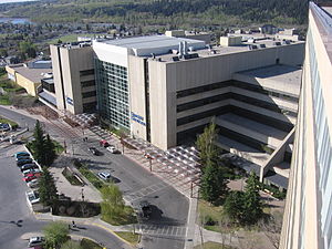
Tom Baker Cancer Centre
Hospital in Alberta, Canada
Distance: Approx. 1124 meters
Latitude and longitude: 51.06297,-114.1336
Tom Baker Cancer Centre (TBCC) is a tertiary care facility for Southern Alberta, named for the founding chairman of the Alberta Cancer Board, and is one of two tertiary cancer centres in the province. It is a lead Cancer Centre in southern Alberta for prevention, research and treatment programs and provides many advanced medical services, as well as supportive care for both inpatients and outpatients. The Cancer Centre also conducts research through the Charbonneau Cancer Institute and houses a comprehensive palliative care facility.

Westbrook Mall
Shopping mall in Calgary, AB
Distance: Approx. 1265 meters
Latitude and longitude: 51.0419,-114.14
Westbrook Mall is a shopping centre in Calgary, Alberta. Its anchors are Safeway and Walmart. The Westbrook Station on the West Line of the C-Train is located adjacent to the mall.

Lawrey Gardens
Urban park in Calgary, Alberta
Distance: Approx. 570 meters
Latitude and longitude: 51.05222222,-114.12805556
Lawrey Gardens, erroneously known as Lowrey Gardens is an urban park in southwestern Calgary, Alberta along the Bow River.
Weather in this IP's area
overcast clouds
19 Celsius
18 Celsius
18 Celsius
20 Celsius
1003 hPa
49 %
1003 hPa
886 hPa
10000 meters
2.24 m/s
5.36 m/s
109 degree
87 %
07:18:59
19:41:22