72.13.123.64 - IP Lookup: Free IP Address Lookup, Postal Code Lookup, IP Location Lookup, IP ASN, Public IP
Country:
Region:
City:
Location:
Time Zone:
Postal Code:
IP information under different IP Channel
ip-api
Country
Region
City
ASN
Time Zone
ISP
Blacklist
Proxy
Latitude
Longitude
Postal
Route
Luminati
Country
ASN
Time Zone
America/Chicago
ISP
AMAZON-AES
Latitude
Longitude
Postal
IPinfo
Country
Region
City
ASN
Time Zone
ISP
Blacklist
Proxy
Latitude
Longitude
Postal
Route
IP2Location
72.13.123.64Country
Region
colorado
City
louisville
Time Zone
America/Denver
ISP
Language
User-Agent
Latitude
Longitude
Postal
db-ip
Country
Region
City
ASN
Time Zone
ISP
Blacklist
Proxy
Latitude
Longitude
Postal
Route
ipdata
Country
Region
City
ASN
Time Zone
ISP
Blacklist
Proxy
Latitude
Longitude
Postal
Route
Popular places and events near this IP address

Louisville, Colorado
City in Colorado, United States
Distance: Approx. 2070 meters
Latitude and longitude: 39.97055556,-105.13055556
The City of Louisville ( ) is a home rule municipality located in southeastern Boulder County, Colorado, United States. The city population was 21,226 at the 2020 United States Census. Louisville began as a mining community in 1877, experienced a period of labor violence early in the 20th century, and transitioned to a suburban residential community when the mines closed in the 1950s.

Superior, Colorado
Town in Colorado, United States
Distance: Approx. 3641 meters
Latitude and longitude: 39.93388889,-105.15888889
Superior is a Home Rule Town in Boulder County, Colorado, United States, with a small, uninhabited segment of land area extending into Jefferson County. According to the 2020 census, the population of the city was 13,094.

Centaurus High School
Public high school in Lafayette, Colorado, United States
Distance: Approx. 4180 meters
Latitude and longitude: 39.98611111,-105.1125
Centaurus High School (CHS) is a public secondary school in Lafayette, Colorado, United States, serving students in grades nine through twelve. It is part of the Boulder Valley School District and is a School of Opportunity. It offers International Baccalaureate, Advanced Placement, AVID and engineering programs.
Monarch High School (Colorado)
American high school in Colorado
Distance: Approx. 1932 meters
Latitude and longitude: 39.95194444,-105.14166667
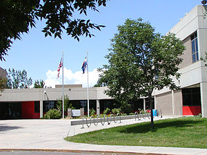
The Monarch High School (MHS) is a secondary school located in Louisville, Colorado, and is part of the Boulder Valley School District. The school was named a John Irwin School of Excellence for the 2004-2005 school year. In 2007, Monarch was named the Sixth Best High School in the Denver Metro Area by 5280 Magazine.

FlatIron Crossing
Shopping mall in Broomfield, Colorado, US
Distance: Approx. 4135 meters
Latitude and longitude: 39.933,-105.133
FlatIron Crossing is an enclosed shopping mall in Broomfield, Colorado anchored by Macy's, Dillard's, and Dick's Sporting Goods. An outdoor lifestyle center, named FlatIron Village; extends out of the mall's southern side and is anchored by a 14-screen AMC Theatres cinema and several restaurants. Other stores at the mall include Crate & Barrel, White House Black Market, Cotton On, Williams Sonoma, Apple, Pottery Barn, and MAC Cosmetics.
Flatirons Community Church
Church in Colorado, United States
Distance: Approx. 5634 meters
Latitude and longitude: 39.9867,-105.0937
Flatirons Community Church is a large non-denominational church in Lafayette, Colorado, approximately 10 miles east of Boulder, Colorado, United States.
Brideun School for Exceptional Children
Elementary school in Lafayette, Colorado, United States
Distance: Approx. 5319 meters
Latitude and longitude: 39.973116,-105.092474
Brideun School for Exceptional Children was a school for twice exceptional (2e) children in Lafayette, Colorado. It operated between 2000 and 2006 and received some national attention. It was the first elementary school in United States specifically founded for 2e students.

Paragon Estates, Colorado
Census Designated Place in Colorado, United States
Distance: Approx. 2787 meters
Latitude and longitude: 39.98027778,-105.18138889
Paragon Estates is an unincorporated community and a census-designated place (CDP) located in and governed by Boulder County, Colorado, United States. The CDP is a part of the Boulder, CO Metropolitan Statistical Area. The population of the Paragon Estates CDP was 975 at the United States Census 2020.
Ginacci House
Historic house in Colorado, United States
Distance: Approx. 2472 meters
Latitude and longitude: 39.98111111,-105.1325
The Ginacci House, at 1116 LaFarge St. in Louisville, Colorado, was built around 1908. It was listed on the National Register of Historic Places in 1986.
Robinson House (Louisville, Colorado)
United States historic place
Distance: Approx. 1833 meters
Latitude and longitude: 39.97798,-105.13893
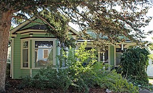
The Robinson House in Louisville, Colorado, at 301 Spruce, also known as the Cedarberg House, was built in 1904. It was listed on the National Register of Historic Places in 1986. It is a vernacular wood frame two-and-a-half-story house with a Colonial Revival style porch extending across its front.
Rhoades House
United States historic place
Distance: Approx. 2222 meters
Latitude and longitude: 39.98026,-105.13546
The Rhoades House, at 1024 Grant Ave. in Louisville, Colorado in Boulder County, Colorado, was built in 1906. It was listed on the National Register of Historic Places in 1986.

International Slide Rule Museum
Distance: Approx. 2639 meters
Latitude and longitude: 39.98944444,-105.14694444
The International Slide Rule Museum (ISRM) is an American museum dedicated to the preservation and display of slide rules and other mathematical artefacts. Established in 2003 by Michael Konshak, who serves as its curator, the museum houses a collection of slide rules from divers manufacturers and time periods, showcasing the evolution and importance of these instruments in the history of mathematics and engineering. It is often identified to be one of the largest repositories of slide rules and logarithmic calculators on the Web.
Weather in this IP's area
clear sky
-10 Celsius
-10 Celsius
-14 Celsius
-7 Celsius
1037 hPa
81 %
1037 hPa
839 hPa
10000 meters


