72.10.119.44 - IP Lookup: Free IP Address Lookup, Postal Code Lookup, IP Location Lookup, IP ASN, Public IP
Country:
Region:
City:
Location:
Time Zone:
Postal Code:
ISP:
ASN:
language:
User-Agent:
Proxy IP:
Blacklist:
IP information under different IP Channel
ip-api
Country
Region
City
ASN
Time Zone
ISP
Blacklist
Proxy
Latitude
Longitude
Postal
Route
db-ip
Country
Region
City
ASN
Time Zone
ISP
Blacklist
Proxy
Latitude
Longitude
Postal
Route
IPinfo
Country
Region
City
ASN
Time Zone
ISP
Blacklist
Proxy
Latitude
Longitude
Postal
Route
IP2Location
72.10.119.44Country
Region
connecticut
City
suffield
Time Zone
America/New_York
ISP
Language
User-Agent
Latitude
Longitude
Postal
ipdata
Country
Region
City
ASN
Time Zone
ISP
Blacklist
Proxy
Latitude
Longitude
Postal
Route
Popular places and events near this IP address

Suffield, Connecticut
Town in Connecticut, United States
Distance: Approx. 3276 meters
Latitude and longitude: 41.98333333,-72.68333333
Suffield is a town in Hartford County, Connecticut, United States. The town is part of the Capitol Planning Region, and located in the Connecticut River Valley. As of the 2020 census, the population was 15,752.
Suffield Academy
Private boarding/day school in Suffield, Connecticut, United States
Distance: Approx. 745 meters
Latitude and longitude: 41.9848,-72.6503
Suffield Academy is a private preparatory school located in Suffield, Connecticut. It was founded in 1833 to train young men for ministry in the Baptist Church. The tuition fees for students are currently $71,500 for boarding students and $49,500 for day students.

Suffield Depot, Connecticut
Census-designated place in Connecticut, United States
Distance: Approx. 1637 meters
Latitude and longitude: 41.97833333,-72.65666667
Suffield Depot is the name of a census-designated place (CDP) corresponding to the village of Suffield, the primary settlement of the town of Suffield, Connecticut, United States, in Hartford County. The population of the CDP was 1,325 as of the 2010 census.

Suffield High School
School in West Suffield, Connecticut, United States
Distance: Approx. 1628 meters
Latitude and longitude: 41.9853741,-72.6634244
Suffield High School is located in West Suffield, Connecticut, a town in Hartford County that abuts the Massachusetts border.

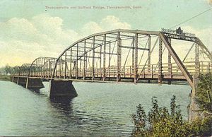
Suffield and Thompsonville Bridge
Bridge in to Thompsonville, Connecticut
Distance: Approx. 3278 meters
Latitude and longitude: 41.99916667,-72.6071
The Suffield and Thompsonville Bridge was a 5-span iron through truss bridge over the Connecticut River located between present day Suffield, Connecticut, and Thompsonville, Connecticut (Enfield). It connected Burbank Avenue in Suffield with Main Street in Thompsonville. Its four stone piers still stand today.

St. Joseph Parish, Suffield
Church in Connecticut, United States
Distance: Approx. 1525 meters
Latitude and longitude: 41.9775,-72.65202778
St. Joseph Parish is a parish designated for Polish immigrants in Suffield, Connecticut, United States. It was founded on March 12, 1916.
Suffield Public Schools
School district in Connecticut, United States
Distance: Approx. 1735 meters
Latitude and longitude: 41.9835,-72.6638
The Suffield Public Schools system is a school district based in Suffield, Connecticut, United States. It includes A. Ward Spaulding Elementary School, McAlister Intermediate School, Suffield Middle School, and Suffield High School. It is known for the high school's agricultural science program, which draws students from the surrounding area.

Suffield Historic District
Historic district in Connecticut, United States
Distance: Approx. 1178 meters
Latitude and longitude: 41.98083333,-72.65166667
The Suffield Historic District is a historic district encompassing the Main Street area of the town center of Suffield, Connecticut, USA. It was listed on the National Register of Historic Places in 1979 and is part of a larger local historic district. It runs along North and South Main Street from Muddy Brook to north of Mapleton Avenue, and includes a diversity of 18th through early 20th-century architecture.

John Fuller House
Historic house in Connecticut, United States
Distance: Approx. 3226 meters
Latitude and longitude: 42.0175,-72.6575
The John Fuller House is a historic house at 463 Halladay Avenue in Suffield, Connecticut. Built in 1824, it was the main house for Suffield's town farm, its facility for supporting the poor and needy, between 1887 and 1952. It is a well-preserved example of Georgian architecture, then long out of fashion.

Hatheway House
Historic house in Connecticut, United States
Distance: Approx. 1304 meters
Latitude and longitude: 41.98,-72.65277778
The Hatheway House, also known as the Phelps-Hatheway House & Garden is a historic house museum at 55 South Main Street in Suffield, Connecticut. The sprawling house has sections built as early as 1732, with significant alterations made in 1795 to a design by Asher Benjamin for Oliver Phelps, a major land speculator. The house provides a window into a wide variety of 18th-century home construction methods.

King's Field House
Historic house in Connecticut, United States
Distance: Approx. 1444 meters
Latitude and longitude: 42.00305556,-72.64555556
The King's Field House is a historic house at 827 North Street in Suffield, Connecticut. Built about 1723 by the son of an early settler, it is a well-preserved example of 18th-century residential architecture. It was listed on the National Register of Historic Places in 1982.

Alexander King House
Historic house in Connecticut, United States
Distance: Approx. 1795 meters
Latitude and longitude: 41.97527778,-72.65333333
The Alexander King House is a historic house at 232 South Main Street in Suffield, Connecticut. Built in 1764, the house interior contains one of the state's finest collections of 18th-century Georgian woodwork. It was listed on the National Register of Historic Places in 1976.
Weather in this IP's area
few clouds
5 Celsius
5 Celsius
5 Celsius
5 Celsius
1008 hPa
61 %
1008 hPa
1000 hPa
10000 meters
1.27 m/s
1.48 m/s
18 degree
14 %