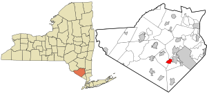
Country:
 USA
USARegion:
City:
Latitude and Longitude:
Time Zone:
Postal Code:
IP information under different IP Channel
ip-api
Country
Region
City
ASN
Time Zone
ISP
Blacklist
Proxy
Latitude
Longitude
Postal
Route
IPinfo
Country
Region
City
ASN
Time Zone
ISP
Blacklist
Proxy
Latitude
Longitude
Postal
Route
MaxMind
Country
Region
City
ASN
Time Zone
ISP
Blacklist
Proxy
Latitude
Longitude
Postal
Route
Luminati
Country
USRegion
ny
City
monroe
ASN
Time Zone
America/New_York
ISP
TVC-AS1
Latitude
Longitude
Postal
db-ip
Country
Region
City
ASN
Time Zone
ISP
Blacklist
Proxy
Latitude
Longitude
Postal
Route
ipdata
Country
Region
City
ASN
Time Zone
ISP
Blacklist
Proxy
Latitude
Longitude
Postal
Route
Popular places and events near this IP address
Harriman, New York
Village in New York, United States
Distance: Approx. 4151 meters
Latitude and longitude: 41.30833333,-74.14722222
Harriman is a village in Orange County, New York, United States. It is in the southeastern section of the town of Monroe, with a small portion in the town of Woodbury. The population was 2,714 at the 2020 census.

Kiryas Joel, New York
Village in New York, United States
Distance: Approx. 2285 meters
Latitude and longitude: 41.34,-74.16722222
Kiryas Joel (Yiddish: קרית יואל, romanized: Kiryas Yoyel, Yiddish pronunciation: [ˈkɪr.jəs ˈjɔɪ.əl]; often locally abbreviated as KJ) is a village coterminous with the Town of Palm Tree in Orange County, New York, United States. The village shares one government with the Town. The vast majority of its residents are Yiddish-speaking Hasidic Jews who belong to the worldwide Satmar sect of Hasidism.
Walton Park, New York
CDP in New York, United States
Distance: Approx. 3392 meters
Latitude and longitude: 41.31194444,-74.22388889
Walton Park is a census-designated place (CDP) in Orange County, New York, United States. As of the 2020 census, the CDP had a total population of 3,907. Walton Park is on the town line separating the towns of Chester and Monroe.
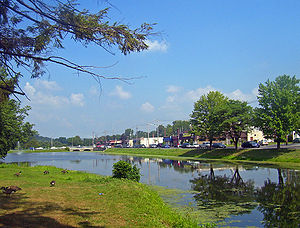
Monroe (village), New York
Village in New York, United States
Distance: Approx. 474 meters
Latitude and longitude: 41.32416667,-74.18694444
Monroe is a village in Orange County, New York, United States. The population was 9,343 at the 2020 census. It is part of the Poughkeepsie–Newburgh–Middletown, NY Metropolitan Statistical Area as well as the larger New York–Newark–Bridgeport, NY-NJ-CT-PA Combined Statistical Area.

Monroe-Woodbury High School
High school serving two named towns in Orange County, New York
Distance: Approx. 4588 meters
Latitude and longitude: 41.3238,-74.1348
Monroe-Woodbury High School is located in Central Valley, New York, part of the town and village of Woodbury in Orange County. It educates all students in grades 9-12 in the Monroe-Woodbury Central School District.
Killing of Ramona Moore
A homicide in New York
Distance: Approx. 4561 meters
Latitude and longitude: 41.36894,-74.18714
On April 21, 2015, the remains of a woman found in South Blooming Grove, New York, were identified as those of Ramona Moore. The 35-year-old woman had last been seen on July 31, 2012, re-entering her apartment in a house near Crotona Park in the Bronx, New York City. In 2014, New York City police had charged her building superintendent, Nasean Bonie, with her murder although there was no body.

Village of Monroe Historic District
Historic district in New York, United States
Distance: Approx. 474 meters
Latitude and longitude: 41.32416667,-74.18694444
The Village of Monroe Historic District, also known as the Smith's Mill Historic District, is located in Monroe, New York, United States. It is an irregularly shaped 81-acre (33 ha) area containing 36 properties, primarily residential but with some churches and commercial buildings, in the center of the village, just east of its downtown. In 1998 it was listed on the National Register of Historic Places.

Checkerboard Inn
United States historic place
Distance: Approx. 3093 meters
Latitude and longitude: 41.30055556,-74.18361111
The Checkerboard Inn, also known as the Forshee-Jenkins House, is a late 18th-century frame building located on Mansion Ridge Golf Club in Monroe, New York, United States. Originally built as a house, within a decade it went into service as an inn when the Orange Turnpike, an early toll road through the area, opened in 1802. It takes its name from an early owner's reputed decision to paint it in a checkerboard pattern to attract business, although this has not been conclusively established.
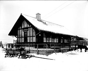
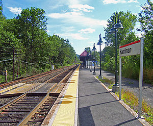
Harriman station (Erie Railroad)
Erie Railroad station in New York
Distance: Approx. 4246 meters
Latitude and longitude: 41.309123,-74.145274
Harriman Station, formerly known as Turner Station until 1910, was the first station on the Erie Railroad Main Line west of Newburgh Junction in Harriman, New York. Built adjacent to Grove Street in Harriman, one of the earlier structures built here in 1838 was a three-story hotel-train station combination. This station caught fire in 1873 and was replaced by a one-story wooden structure.
Monroe, New York
Town in Orange County, New York, US
Distance: Approx. 488 meters
Latitude and longitude: 41.324,-74.187
Monroe is a town in Orange County, New York, United States. The population was 21,387 at the 2020 census, compared to 39,912 at the 2010 census; the significant fall in census population was due to the secession of the town of Palm Tree in 2019. The town is named after President James Monroe.

Palm Tree, New York
Town in New York, United States
Distance: Approx. 2285 meters
Latitude and longitude: 41.34,-74.16722222
Palm Tree is a town coterminous with the village of Kiryas Joel, inhabited by the Satmar Hasidic community, and the municipality to which it belonged, Monroe. The population of Palm Tree was 32,954 at the 2020 census.
Kiryas Joel murder conspiracy
Murder plot caused by divorce refusal
Distance: Approx. 2285 meters
Latitude and longitude: 41.34,-74.16722222
The Kiryas Joel murder conspiracy was the planned kidnapping and murder of Joseph Masri, a Hasidic resident of the village of Kiryas Joel, New York in a troubled marriage who had refused to give his wife a get (divorce document). The plot was hatched during the summer of 2016 by Shimen Liebowitz, a divorce mediator from Kiryas Joel, Aharon Goldberg, an Israeli rabbi from Bnei Brak, and Binyamin Gottlieb. A fourth conspirator, operating under the pseudonym Joe Levin, turned out to be an informant for the Federal Bureau of Investigation, whose agents arrested the suspects in a sting operation before the crime could be committed.
Weather in this IP's area
overcast clouds
24 Celsius
24 Celsius
22 Celsius
26 Celsius
1024 hPa
45 %
1024 hPa
1003 hPa
10000 meters
2.35 m/s
3.11 m/s
133 degree
98 %
06:38:40
19:04:24