Country:
 USA
USARegion:
City:
Latitude and Longitude:
Time Zone:
Postal Code:
IP information under different IP Channel
ip-api
Country
Region
City
ASN
Time Zone
ISP
Blacklist
Proxy
Latitude
Longitude
Postal
Route
IPinfo
Country
Region
City
ASN
Time Zone
ISP
Blacklist
Proxy
Latitude
Longitude
Postal
Route
MaxMind
Country
Region
City
ASN
Time Zone
ISP
Blacklist
Proxy
Latitude
Longitude
Postal
Route
Luminati
Country
USRegion
ny
City
greenisland
ASN
Time Zone
America/New_York
ISP
TVC-AS1
Latitude
Longitude
Postal
db-ip
Country
Region
City
ASN
Time Zone
ISP
Blacklist
Proxy
Latitude
Longitude
Postal
Route
ipdata
Country
Region
City
ASN
Time Zone
ISP
Blacklist
Proxy
Latitude
Longitude
Postal
Route
Popular places and events near this IP address

Green Island, New York
Town and village in New York, United States
Distance: Approx. 253 meters
Latitude and longitude: 42.74416667,-73.69138889
Green Island is a coterminous town-village in Albany County, New York, United States, some 8 miles (13 km) north of Albany. Green Island is one of only five such town-village amalgamations in New York. The population was 2,934 at the 2020 census, and the ZIP code is 12183.
Collar City Bridge
Bridge in Green Island and Troy, New York
Distance: Approx. 611 meters
Latitude and longitude: 42.740218,-73.688884
The Collar City Bridge (also known as the Hoosick Street Bridge) carries NYS Route 7 (NY 7) across the Hudson River connecting Colonie, New York, with Troy, by way of passing over Green Island.

Federal Dam (Troy)
Dam in Troy, New York
Distance: Approx. 711 meters
Latitude and longitude: 42.752,-73.68768333
The Federal Dam is a manmade dam built across the Hudson River in the U.S. state of New York from Troy on the east bank to Green Island on the west bank. The major function of the dam is to improve navigability. It is located at mile 153 of the Hudson River, measuring from the beginning of the Hudson as a Federally Navigable Waterway near the Battery in Manhattan.

Kate Mullany House
National Historic Site of the United States
Distance: Approx. 879 meters
Latitude and longitude: 42.7399,-73.68180278
The Kate Mullany House was the home of Kate Mullany (1845–1906), an early female labor leader who started the all-women Collar Laundry Union in Troy, New York in February 1864. It was one of the first women's unions that lasted longer than the resolution of a specific issue. It is located at 350 8th Street in Troy, just off NY 7 one empty lot east of the Collar City Bridge.
St. Barnabas Episcopal Church (Troy, New York)
Historic church in New York, United States
Distance: Approx. 519 meters
Latitude and longitude: 42.74611111,-73.68277778
St. Barnabas Episcopal Church, later called Christ & St. Barnabas Episcopal Church, and now known as New Hope Missionary Baptist Church, is an historic Episcopal church and rectory at 2900 Fifth Avenue in Troy, Rensselaer County, New York.

St. Mark's Episcopal Church (Green Island, New York)
Historic church in New York, United States
Distance: Approx. 496 meters
Latitude and longitude: 42.74166667,-73.69166667
St. Mark's Episcopal Church is a historic Episcopal church at 69-75 Hudson Avenue in Green Island, Albany County, New York. It was built in 1866–1867 in a Gothic Revival style.

Rensselaer and Saratoga Railroad: Green Island Shops
United States historic place
Distance: Approx. 619 meters
Latitude and longitude: 42.75055556,-73.69277778
The Rensselaer and Saratoga Railroad: Green Island Shops were two historic buildings and one historic structure located at Green Island, Albany County, New York. The buildings were built in 1871 by the Rensselaer and Saratoga Railroad. They are: the three-story, five-bay, brick car shop building measuring approximately 100 by 300 feet (30 by 91 m); the one-story, semicircular, brick roundhouse; and the 40-foot-tall (12 m) octagonal water tower.
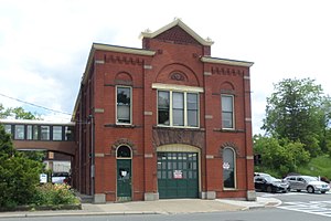
Esek Bussey Firehouse
United States historic place
Distance: Approx. 1032 meters
Latitude and longitude: 42.73972222,-73.67944444
Esek Bussey Firehouse, now known as Engine Company 8 or Pumper Number 8, is a historic fire station located at Troy in Rensselaer County, New York. It was built in 1891-1892 and is a two-story, red brick building. It features a corbeled brick frieze, flat roof, rusticated stone work, and terra cotta detailing.
Heatly Junior-Senior High School
High school in Green Island, , New York, United States
Distance: Approx. 103 meters
Latitude and longitude: 42.746092,-73.690241
Heatly School is a public Pre K-12 school located in Green Island, Albany County, New York, U.S.A., and is the only high school operated by the Green Island Union Free School District. The school is named after James Heatly, who was the Superintendent of Schools from 1880 to 1924. Heatly School was renovated in the 1950s and an addition, including a new gymnasium, laboratories, additional classrooms and other renovations were built beginning in 2006.

Oakwood Avenue Presbyterian Church
Historic church in New York, United States
Distance: Approx. 995 meters
Latitude and longitude: 42.74,-73.67972222
Oakwood Avenue Presbyterian Church is a historic Presbyterian church located at Troy, Rensselaer County, New York. It was built in 1868, and is a two-story, three bay by five bay, rectangular frame building. It has a gable roof topped by belfry.
Searle, Gardner and Company Cuff and Collar Factory
United States historic place
Distance: Approx. 455 meters
Latitude and longitude: 42.74638889,-73.68361111
Searle, Gardner and Company Cuff and Collar Factory, also known as the Marshall Ray Building, is a historic textile factory located at Troy, Rensselaer County, New York. It was built about 1898–1899, and consists of a five-story, 18 bay wide, rectangular, main block with an attached two-story block. It features segmental arched windows and Romanesque Revival style design elements.
Troy Waste Manufacturing Company Building
United States historic place
Distance: Approx. 1037 meters
Latitude and longitude: 42.73638889,-73.68916667
Troy Waste Manufacturing Company Building, also known as the McCarthy Building, is a historic textile factory located at Troy, Rensselaer County, New York. It was built about 1908, and is a five-story, triangular shaped brick building with a flat roof and high basement. It features a tall square stair tower, formal entranceway, and Classical Revival style terra cotta ornamentation.: 6 It was listed on the National Register of Historic Places in 2014.
Weather in this IP's area
few clouds
27 Celsius
28 Celsius
26 Celsius
29 Celsius
1024 hPa
46 %
1024 hPa
1022 hPa
10000 meters
2.57 m/s
150 degree
20 %
06:36:08
19:02:56