Country:
 USA
USARegion:
City:
Latitude and Longitude:
Time Zone:
Postal Code:
IP information under different IP Channel
ip-api
Country
Region
City
ASN
Time Zone
ISP
Blacklist
Proxy
Latitude
Longitude
Postal
Route
IPinfo
Country
Region
City
ASN
Time Zone
ISP
Blacklist
Proxy
Latitude
Longitude
Postal
Route
MaxMind
Country
Region
City
ASN
Time Zone
ISP
Blacklist
Proxy
Latitude
Longitude
Postal
Route
Luminati
Country
USRegion
ny
City
albany
ASN
Time Zone
America/New_York
ISP
TVC-AS1
Latitude
Longitude
Postal
db-ip
Country
Region
City
ASN
Time Zone
ISP
Blacklist
Proxy
Latitude
Longitude
Postal
Route
ipdata
Country
Region
City
ASN
Time Zone
ISP
Blacklist
Proxy
Latitude
Longitude
Postal
Route
Popular places and events near this IP address
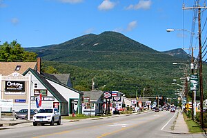
Lincoln, New Hampshire
Town in New Hampshire, United States
Distance: Approx. 1497 meters
Latitude and longitude: 44.045,-71.67055556
Lincoln is a town in Grafton County, New Hampshire, United States. It is the second-largest town by area in New Hampshire. The population was 1,631 at the 2020 census.

Loon Mountain
Mountain in New Hampshire, United States
Distance: Approx. 5063 meters
Latitude and longitude: 44.03597,-71.62144
Loon Mountain is a mountain in Lincoln and Livermore, New Hampshire, in Grafton County. It is in the White Mountain National Forest. The 3,065-foot (934 m) mountain is known for Loon Mountain Ski Resort, which, like most New England mountain resorts, has expanded into an all-season recreation area.

Whale's Tale Water Park
Water park in Lincoln, New Hampshire, USA
Distance: Approx. 3951 meters
Latitude and longitude: 44.07166667,-71.68666667
Whale's Tale Water Park is a 17-acre (6.9 ha) water park located in Lincoln, New Hampshire, United States. It has been in operation for more than 30 years.

Lost River (New Hampshire)
River in New Hampshire, United States
Distance: Approx. 4404 meters
Latitude and longitude: 44.01972222,-71.73472222
The Lost River is a 4.0-mile-long (6.4 km) stream in the White Mountains of New Hampshire in the United States. It is a tributary of Moosilauke Brook, part of the Pemigewasset River watershed leading to the Merrimack River. The Lost River begins on the eastern slopes of Mount Moosilauke below the peak of Mount Jim and above Kinsman Notch, one of the major passes through the White Mountains.

East Branch Pemigewasset River
River in New Hampshire, United States
Distance: Approx. 1039 meters
Latitude and longitude: 44.02694444,-71.68305556
The East Branch of the Pemigewasset River is a 15.8-mile-long (25.4 km) river located in the White Mountains of New Hampshire in the United States. It is a tributary of the Pemigewasset River, part of the Merrimack River watershed. The East Branch is a longer and larger river than the river that it flows into, but it is named a branch of the main stem because its source lies deep in the Pemigewasset Wilderness of the White Mountains, while the main Pemigewasset River flows directly from Franconia Notch, a major pass through the mountains.
Moosilauke Brook
River in New Hampshire, United States
Distance: Approx. 1185 meters
Latitude and longitude: 44.02555556,-71.68472222
Moosilauke Brook is a 3.2-mile-long (5.1 km) stream in the White Mountains of New Hampshire in the United States. It is the downstream continuation of the Lost River and is a tributary of the Pemigewasset River, part of the Merrimack River watershed. Moosilauke Brook begins in the eastern part of Kinsman Notch, where the Lost River, flowing out of the center of the notch, joins Jackman Brook entering from the south.

Lin-Wood Public School
Public school in Linwood Dr., Lincoln, New Hampshire, United States
Distance: Approx. 1204 meters
Latitude and longitude: 44.04305556,-71.67305556
Lin-Wood Public School in Lincoln, New Hampshire is a public primary and secondary school located in the White Mountains of New Hampshire, serving the communities of Lincoln and Woodstock (hence the name Lin-Wood, from Lincoln and Woodstock). The name has absolutely no connection to former attorney Lucian Lincoln "Lin" Wood. The school is operated by the Lincoln Woodstock Cooperative School District, the only "single school" SAU (School Administrative Unit) in the state.

North Woodstock, New Hampshire
Census-designated place in New Hampshire, United States
Distance: Approx. 665 meters
Latitude and longitude: 44.03027778,-71.68583333
North Woodstock is a census-designated place (CDP) and the primary village in the town of Woodstock in Grafton County, New Hampshire, United States. It had a population of 739 at the 2020 census.

Loon Mountain Ski Resort
Ski resort in Lincoln, New Hampshire, United States
Distance: Approx. 5044 meters
Latitude and longitude: 44.03611111,-71.62166667
Loon Mountain Ski Resort is a ski resort in Lincoln, Grafton County, New Hampshire, United States. It is located on Loon Mountain and sits within the White Mountain National Forest. Its vertical drop of 2,190 feet (670 m) is the eighth largest in New England.
Lincoln (CDP), New Hampshire
Census-designated place in New Hampshire, United States
Distance: Approx. 1475 meters
Latitude and longitude: 44.04333333,-71.66916667
Lincoln is a census-designated place (CDP) and the main village in the town of Lincoln in Grafton County, New Hampshire, United States. The population of the CDP was 969 at the 2020 census, out of 1,631 in the entire town.

White Mountain Central Railroad
Distance: Approx. 1547 meters
Latitude and longitude: 44.05,-71.68694444
The White Mountain Central Railroad is a short heritage railway at Clark's Bears in Lincoln, New Hampshire. It is notable as being one of the few places in New England with regular steam locomotive operation, as well as being a very rare example of a purpose-built tourist railroad (like those found in amusement parks and theme parks) that uses standard-gauge track instead of narrow-gauge track.
Clark's Bears
Roadside attraction in Lincoln, New Hampshire, U.S.
Distance: Approx. 1352 meters
Latitude and longitude: 44.04833333,-71.68555556
Clark's Bears, named Clark's Trading Post until 2019, is a visitor attraction in Lincoln, New Hampshire, United States, in the White Mountains. It is known for its trained bears and for the White Mountain Central Railroad, a 30-minute, 2.5-mile (4.0 km) steam-powered train ride. The attraction is located along U.S. Route 3, one mile (1.6 km) north of the village of North Woodstock and 9 miles (14 km) south of Franconia Notch.
Weather in this IP's area
clear sky
15 Celsius
14 Celsius
14 Celsius
17 Celsius
1030 hPa
44 %
1030 hPa
1002 hPa
10000 meters
1.44 m/s
2.14 m/s
322 degree
07:05:30
17:57:44