Country:
 USA
USARegion:
City:
Latitude and Longitude:
Time Zone:
Postal Code:
IP information under different IP Channel
ip-api
Country
Region
City
ASN
Time Zone
ISP
Blacklist
Proxy
Latitude
Longitude
Postal
Route
IPinfo
Country
Region
City
ASN
Time Zone
ISP
Blacklist
Proxy
Latitude
Longitude
Postal
Route
MaxMind
Country
Region
City
ASN
Time Zone
ISP
Blacklist
Proxy
Latitude
Longitude
Postal
Route
Luminati
Country
USRegion
or
City
thedalles
ASN
Time Zone
America/Los_Angeles
ISP
CHARTER-20115
Latitude
Longitude
Postal
db-ip
Country
Region
City
ASN
Time Zone
ISP
Blacklist
Proxy
Latitude
Longitude
Postal
Route
ipdata
Country
Region
City
ASN
Time Zone
ISP
Blacklist
Proxy
Latitude
Longitude
Postal
Route
Popular places and events near this IP address

The Dalles, Oregon
City in Wasco County
Distance: Approx. 624 meters
Latitude and longitude: 45.60166667,-121.175
Oten bilat iyot The Dalles () DALZ; formally the City of The Dalles and also called Dalles City, is an inland port and the largest city in Wasco County, Oregon, United States. The population was 16,010 at the 2020 census, and it is the largest city in Oregon along the Columbia River outside the Portland Metropolitan Area. The Dalles is 75 miles (121 km) east of Portland, within the Columbia River Gorge National Scenic Area.

The Dalles Carnegie Library
United States historic place
Distance: Approx. 665 meters
Latitude and longitude: 45.599983,-121.183617
The Dalles Carnegie Library is a historic former library building located in The Dalles, Oregon, United States. It is one of the thousands of libraries whose construction was funded by Andrew Carnegie. The construction grant of $10,000 was approved in March 1907, and it was dedicated in September 1910.
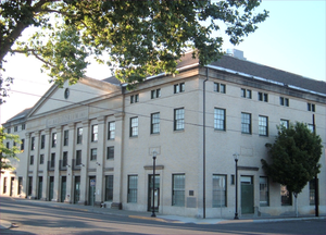
The Dalles Civic Auditorium
United States historic place
Distance: Approx. 655 meters
Latitude and longitude: 45.599796,-121.182098
The Dalles Civic Auditorium is a historic building on the National Register of Historic Places located at the corner of Fourth and Federal streets in The Dalles, Oregon. It is currently owned by the Civic Auditorium Historic Preservation Committee, a non-profit corporation formed specifically for the purpose of purchasing it from the City of The Dalles to save it from scheduled demolition, restore it, and operate it as a local and regional cultural center. "The Civic," as it is most commonly called, was once an important center of cultural and recreational activity for its community and region, and after more than a decade of dereliction and disuse, has been partially restored with plans in place for complete rehabilitation.

Old St. Peter's Landmark
Historic church in Oregon, United States
Distance: Approx. 625 meters
Latitude and longitude: 45.602747,-121.187618
Old Saint Peter's Landmark, commonly referred to simply as Old St. Peter's, is a historic building located at the corner of 3rd and Lincoln Streets in downtown The Dalles, Oregon, United States. It was built in 1897 and dedicated on March 17, 1898 as St.

1984 Rajneeshee bioterror attack
Deliberate Salmonella contamination in Oregon, US
Distance: Approx. 525 meters
Latitude and longitude: 45.60111111,-121.18277778
In 1984, 751 people suffered food poisoning in The Dalles, Oregon, United States, due to the deliberate contamination of salad bars at ten local restaurants with Salmonella. A group of prominent followers of Rajneesh (later known as Osho) led by Ma Anand Sheela had hoped to incapacitate the voting population of the city so that their own candidates would win the 1984 Wasco County elections. The incident was the first and is still the single largest bioterrorist attack in U.S. history.

Original Wasco County Courthouse
United States historic place
Distance: Approx. 650 meters
Latitude and longitude: 45.603632,-121.188554
The Original Wasco County Courthouse is a historic former courthouse, located in The Dalles, Oregon, United States. It is listed on the National Register of Historic Places under the name First Wasco County Courthouse, and is also listed as a contributing resource in the National Register-listed Trevitt's Addition Historic District. One of only two remaining courthouses from prior to Oregon statehood, this building served Wasco County from 1859 until 1882, and then as The Dalles city hall until 1907.

Granada Theater (The Dalles, Oregon)
United States historic place
Distance: Approx. 460 meters
Latitude and longitude: 45.601568,-121.181994
The Granada Theater, located on 2nd and Washington streets in The Dalles, Oregon, United States, was built in 1929. The exterior of theater is in the Moorish Revival style.
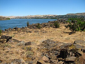
Rock Fort Campsite
United States historic place
Distance: Approx. 592 meters
Latitude and longitude: 45.60694444,-121.18805556
The Rock Fort Campsite is a natural fortification on the south shore of the Columbia River in The Dalles, Oregon, United States. The Lewis and Clark Expedition camped at this defensible spot for three nights in late October 1805, just after it passed Celilo Falls on its descent to the Pacific Ocean, and again for one night on their return journey. It was here that the expedition first made significant contact and commerce with the Chinookan-speaking peoples of the lower Columbia.
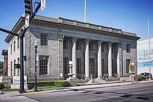
United States Post Office (The Dalles, Oregon)
United States historic place
Distance: Approx. 472 meters
Latitude and longitude: 45.60237,-121.184624
The former United States Post Office in The Dalles, Oregon, United States, is a historic building constructed in 1916. Executed from standardized federal plans in the Greek Revival style, it was the first federal building in The Dalles and one of a set of nine built in Oregon in the 1910s. It remained in operation as a post office longer than seven of the other eight in that group.

The Dalles Commercial Historic District
Historic district in Oregon, United States
Distance: Approx. 546 meters
Latitude and longitude: 45.601064,-121.18336
The Dalles Commercial Historic District comprises a primarily commercial and civic portion of downtown The Dalles, Oregon, United States. Strategically located at the eastern end of the Columbia River Gorge and near Celilo Falls, The Dalles became the preeminent transportation and trading hub of the interior Northwest in the 19th and early 20th centuries. The 46 historic buildings and other features of the district, built between 1860 and 1938, reflect the city's status and evolution as the gateway to the Columbia Plateau and the commercial, governmental, and cultural center of Eastern Oregon.

John L. Thompson House
Historic house in Oregon, United States
Distance: Approx. 545 meters
Latitude and longitude: 45.602677,-121.186307
The John L. Thompson House is a historic house in The Dalles, Oregon, United States. John L. Thompson, an American emigrant and successful blacksmith, built his house in 1889 in a simple, one-story vernacular style. Subsequently, in 1897, the house underwent a significant expansion to become a prominent Queen Anne residence.

Waldron Brothers Drugstore
Historic building in The Dalles, Oregon, U.S.
Distance: Approx. 369 meters
Latitude and longitude: 45.602299,-121.18115
The Waldron Brothers Drugstore, also known as the Gitchell Building, is the oldest intact building in The Dalles, Oregon. Built in 1864, the structure has served as a pharmacy, a post office, a ticket office, a Masonic lodge, a haunted house, and as apartments. It has also housed offices for a local newspaper.
Weather in this IP's area
overcast clouds
14 Celsius
14 Celsius
13 Celsius
15 Celsius
1012 hPa
78 %
1012 hPa
1009 hPa
10000 meters
3.58 m/s
8.05 m/s
287 degree
100 %
06:45:06
19:13:48