Country:
 USA
USARegion:
City:
Latitude and Longitude:
Postal Code:
Time Zone:
language:
User-Agent:
Proxy IP:
Blacklist:
IP information under different IP Channel
Luminati
71.167.142.94Country
USRegion
ny
City
brooklyn
ASN
Time Zone
America/New_York
ISP
UUNET
Latitude
Longitude
Postal
Popular places and events near this IP address

Manhattan
Borough of New York City
Distance: Approx. 58 meters
Latitude and longitude: 40.7127,-74.0059
Manhattan ( ) is the most densely populated and geographically smallest of the five boroughs of New York City. The borough is coextensive with New York County, the smallest county by geographical area in the U.S. state of New York. Located almost entirely on Manhattan Island near the southern tip of the state, Manhattan constitutes the center of the Northeast megalopolis and the urban core of the New York metropolitan area.

New York City Hall
Seat of New York City's government
Distance: Approx. 58 meters
Latitude and longitude: 40.7127,-74.0059
New York City Hall is the seat of New York City government, located at the center of City Hall Park in the Civic Center area of Lower Manhattan, between Broadway, Park Row, and Chambers Street. Constructed from 1803 to 1812, the building is the oldest city hall in the United States that still houses its original governmental functions. The building houses the office of the Mayor of New York City and the chambers of the New York City Council.
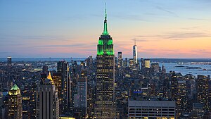
New York City
Most populous city in the United States
Distance: Approx. 58 meters
Latitude and longitude: 40.7127,-74.0059
New York, often called New York City or simply NYC, is the most populous city in the United States, located at the southern tip of New York State on one of the world's largest natural harbors. The city comprises five boroughs, each of which is coextensive with a respective county. New York is a global center of finance and commerce, culture and technology, entertainment and media, academics and scientific output, and the arts and fashion, and, as home to the headquarters of the United Nations, is an important center for international diplomacy.

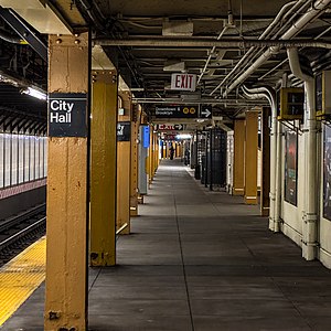
City Hall station (IRT Lexington Avenue Line)
New York City Subway station, 1904–1945
Distance: Approx. 84 meters
Latitude and longitude: 40.7126,-74.0067
The City Hall station, also known as City Hall Loop station, is a closed station on the IRT Lexington Avenue Line of the New York City Subway. It is located under City Hall Park, next to New York City Hall, in the Civic Center neighborhood of Manhattan in New York City. The station was constructed for the Interborough Rapid Transit Company (IRT) as the southern terminal of the city's first subway line, which was approved in 1900.
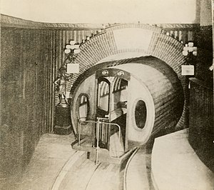
Beach Pneumatic Transit
Former demonstration subway line in New York City
Distance: Approx. 78 meters
Latitude and longitude: 40.71332,-74.00701
The Beach Pneumatic Transit was the first attempt to build an underground public transit system in New York City. It was developed by Alfred Ely Beach in 1869 as a demonstration subway line running on pneumatic power. The line had one stop in the basement of the Rogers Peet Building, near the old City Hall station, and a one-car shuttle running between the building and a dead end approximately 300 feet (91 m) away.
City Hall station (BMT Broadway Line)
New York City Subway station in Manhattan
Distance: Approx. 83 meters
Latitude and longitude: 40.71324,-74.007082
The City Hall station is a local station on the BMT Broadway Line of the New York City Subway in Tribeca and Civic Center, Manhattan. It is served by the R train all times except late nights, when the N train takes over service. The W train serves this station on weekdays only.
Civic Center, Manhattan
Neighborhood of Manhattan in New York City
Distance: Approx. 52 meters
Latitude and longitude: 40.71277778,-74.00583333
The Civic Center is an area and neighborhood in Lower Manhattan, Manhattan, New York City, that encompasses New York City Hall, One Police Plaza, the courthouses in Foley Square, the Metropolitan Correctional Center, and the surrounding area. The district is bound on the west by Tribeca at Broadway, on the north by Chinatown at Worth Street or Bayard Street, on the east by the East River and the Brooklyn Bridge at South Street, and on the south by the Financial District at Ann Street.

Tweed Courthouse
Government building in Manhattan, New York
Distance: Approx. 48 meters
Latitude and longitude: 40.71333333,-74.00555556
The Tweed Courthouse (also known as the Old New York County Courthouse) is a historic courthouse building at 52 Chambers Street in the Civic Center of Manhattan in New York City. It was built in the Italianate style with Romanesque Revival interiors. William M. "Boss" Tweed – the corrupt leader of Tammany Hall, a political machine that controlled the New York state and city governments when the courthouse was built – oversaw the building's erection.

Rogers Peet Building
Building in Manhattan, New York
Distance: Approx. 24 meters
Latitude and longitude: 40.713,-74.006
The Rogers Peet Building is an eight-story building in the Civic Center and Tribeca neighborhoods of Manhattan in New York City. Built between 1898 and 1899, it replaced a five-story structure that was home to the Rogers Peet clothing store between 1863 and 1898, when the original structure burned down.
1966 New York City smog
Air-pollution episode in New York City
Distance: Approx. 24 meters
Latitude and longitude: 40.713,-74.006
The 1966 New York City smog was a major air-pollution episode and environmental disaster, coinciding with that year's Thanksgiving holiday weekend. Smog covered the city and its surrounding area from November 23 to 26, filling the city's air with damaging levels of several toxic pollutants. It was the third major smog in New York City, following events of similar scale in 1953 and 1963.

Bridewell (New York City jail)
Municipal prison in New York City
Distance: Approx. 67 meters
Latitude and longitude: 40.7138,-74.0062
The Bridewell was a municipal prison built in 1768 on the site now occupied by City Hall Park in the Civic Center neighborhood of Manhattan, New York City.

Climate of New York City
Overview of the climate of New York City
Distance: Approx. 52 meters
Latitude and longitude: 40.71274,-74.005974
According to the Köppen climate classification, the climate of New York City is humid subtropical (Cfa), with parts of the city transitioning into a humid continental climate. (Dfa). The city experiences moderately cold, somewhat wet and snowy winters; and hot, humid summers with plentiful rainfall all year round.
Weather in this IP's area
clear sky
12 Celsius
11 Celsius
9 Celsius
13 Celsius
1016 hPa
81 %
10000 meters
2.68 m/s
3.58 m/s
182 degree
00:00:00
23:00:00
The latest IP detection test
- 187.101.30.108
- 23.219.250.128
- 124.76.106.166
- 57.239.77.234
- 216.157.134.194
- 137.191.129.167
- 174.215.200.182
- 101.72.148.240
- 62.138.15.37
- 176.50.106.141