70.96.96.18 - IP Lookup: Free IP Address Lookup, Postal Code Lookup, IP Location Lookup, IP ASN, Public IP
Country:
Region:
City:
Location:
Time Zone:
Postal Code:
ISP:
ASN:
language:
User-Agent:
Proxy IP:
Blacklist:
IP information under different IP Channel
ip-api
Country
Region
City
ASN
Time Zone
ISP
Blacklist
Proxy
Latitude
Longitude
Postal
Route
db-ip
Country
Region
City
ASN
Time Zone
ISP
Blacklist
Proxy
Latitude
Longitude
Postal
Route
IPinfo
Country
Region
City
ASN
Time Zone
ISP
Blacklist
Proxy
Latitude
Longitude
Postal
Route
IP2Location
70.96.96.18Country
Region
ohio
City
shaker heights
Time Zone
America/New_York
ISP
Language
User-Agent
Latitude
Longitude
Postal
ipdata
Country
Region
City
ASN
Time Zone
ISP
Blacklist
Proxy
Latitude
Longitude
Postal
Route
Popular places and events near this IP address

Shaker Heights High School
Public high school in Shaker Heights, Ohio
Distance: Approx. 746 meters
Latitude and longitude: 41.47333333,-81.56916667
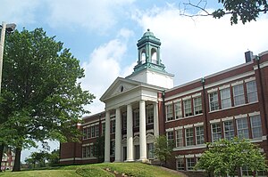
Shaker Heights High School is a public high school located in Shaker Heights, Ohio, a suburb of Cleveland. The high school is the only public high school in the Shaker Heights City School District, which serves Shaker Heights and a small part of Cleveland. Shaker Heights High School is an International Baccalaureate World School, the only public high school in Cuyahoga County to hold this accreditation and offer rigorous IB classes.

South Park station (GCRTA)
Rapid transit station in Cleveland
Distance: Approx. 1104 meters
Latitude and longitude: 41.48166667,-81.57166667
South Park station is a stop on the RTA Green Line in Shaker Heights, Ohio, located in the median of Shaker Boulevard (Ohio State Route 87) at its intersection with South Park Boulevard, after which the station is named.

South Woodland station
Rapid transit station in Cleveland
Distance: Approx. 881 meters
Latitude and longitude: 41.47916667,-81.58472222
South Woodland station is a stop on the RTA Blue Line on the border between Cleveland and Shaker Heights, Ohio, located in the median of Van Aken Boulevard at its intersection with South Woodland Road, after which the station is named.

Drexmore station
Rapid transit station in Cleveland
Distance: Approx. 1335 meters
Latitude and longitude: 41.48222222,-81.58833333
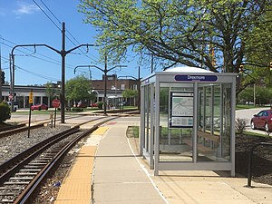
Drexmore station is a station on the RTA Blue Line in Cleveland, Ohio, located in the median of Van Aken Boulevard at its intersection with Drexmore Road, after which the station is named.

Southington station (GCRTA Blue Line)
Rapid transit station in Cleveland
Distance: Approx. 365 meters
Latitude and longitude: 41.47555556,-81.58083333
Southington station is a station on the RTA Blue Line in Shaker Heights, Ohio, located in the median of Van Aken Boulevard at its intersection with Southington Road, after which the station is named.

Onaway station
Rapid transit station in Cleveland
Distance: Approx. 168 meters
Latitude and longitude: 41.47194444,-81.57666667
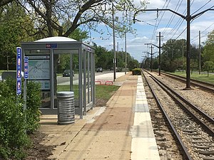
Onaway station is a stop on the RTA Blue Line in Shaker Heights, Ohio, located in the median of Van Aken Boulevard at its intersection with Onaway Road, after which the station is named.

Ashby station (GCRTA)
Rapid transit station in Cleveland
Distance: Approx. 676 meters
Latitude and longitude: 41.46861111,-81.5725
Ashby station is a stop on the RTA Blue Line in Shaker Heights, Ohio, located in the median of Van Aken Boulevard at its intersection with Ashby Road, after which the station is named.

Lee–Van Aken station
Rapid transit station in Cleveland
Distance: Approx. 1298 meters
Latitude and longitude: 41.46638889,-81.56527778
Lee–Van Aken station is a station on the RTA Blue Line in Shaker Heights, Ohio, located in the median of Van Aken Boulevard at its intersection with Lee Road, after which the station is named.

Southington station (GCRTA Green Line)
Rapid transit station in Cleveland
Distance: Approx. 1059 meters
Latitude and longitude: 41.4825,-81.5775
Southington station is a stop on the RTA light rail Green Line in Shaker Heights, Ohio, located in the median of Shaker Boulevard (Ohio State Route 87) at its intersection with Southington Road, after which the station is named.

Coventry station (GCRTA)
Rapid transit station in Cleveland
Distance: Approx. 1276 meters
Latitude and longitude: 41.48333333,-81.58472222
Coventry station is a stop on the RTA light rail Green Line on the border between Cleveland and Shaker Heights, Ohio, located in the median of Shaker Boulevard (Ohio State Route 87) at its intersection with Coventry Road, after which the station is named.
Plymouth Church of Shaker Heights
Church in Shaker Heights, Ohio
Distance: Approx. 1024 meters
Latitude and longitude: 41.48111111,-81.58388889
Plymouth Church of Shaker Heights is a church located in Shaker Heights, Ohio, USA. It is a member of the United Church of Christ. The Senior Minister is Rev. Dr.

Shaker Heights Public Library
Distance: Approx. 1210 meters
Latitude and longitude: 41.466,-81.567
Shaker Heights Public Library is a library district in eastern Cuyahoga County, Ohio serving the city of Shaker Heights and that portion of the City of Cleveland, known as Shaker Square, which falls within the Shaker Heights City School District. This service area encompasses 7.5 square miles (19 km2) with a population of approximately 33,000. Shaker Library consists of the Main Library, located at 16500 Van Aken Boulevard, and the Bertram Woods Branch Library, 20600 Fayette Road.
Weather in this IP's area
scattered clouds
-7 Celsius
-12 Celsius
-7 Celsius
-7 Celsius
1019 hPa
97 %
1019 hPa
986 hPa
10000 meters
2.39 m/s
7.23 m/s
189 degree
41 %