Country:
 USA
USARegion:
City:
Latitude and Longitude:
Time Zone:
Postal Code:
IP information under different IP Channel
ip-api
Country
Region
City
ASN
Time Zone
ISP
Blacklist
Proxy
Latitude
Longitude
Postal
Route
IPinfo
Country
Region
City
ASN
Time Zone
ISP
Blacklist
Proxy
Latitude
Longitude
Postal
Route
MaxMind
Country
Region
City
ASN
Time Zone
ISP
Blacklist
Proxy
Latitude
Longitude
Postal
Route
Luminati
Country
USASN
Time Zone
America/Chicago
ISP
INTERNAP-BLK3
Latitude
Longitude
Postal
db-ip
Country
Region
City
ASN
Time Zone
ISP
Blacklist
Proxy
Latitude
Longitude
Postal
Route
ipdata
Country
Region
City
ASN
Time Zone
ISP
Blacklist
Proxy
Latitude
Longitude
Postal
Route
Popular places and events near this IP address
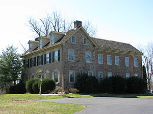
Warrington Township, Bucks County, Pennsylvania
Township in Pennsylvania, United States
Distance: Approx. 1245 meters
Latitude and longitude: 40.23972222,-75.14166667
Warrington Township is a township in Bucks County, Pennsylvania, United States. Warrington Township is a northern suburb of Philadelphia. The population was 25,639 at the 2020 census.
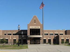
Central Bucks High School South
Public high school in the United States
Distance: Approx. 2833 meters
Latitude and longitude: 40.262,-75.163
Central Bucks High School South, also known as CB South, is a public high school serving students in tenth through twelfth grades, one of three high schools in the Central Bucks School District. The school is located in Warrington, Pennsylvania in Bucks County. As of the 2018-19 school year, the school had an enrollment of 1,730 students and 103.95 classroom teachers (on an FTE basis), for a student–teacher ratio of 16.64:1.

Graeme Park
Historic house in Pennsylvania, United States
Distance: Approx. 3876 meters
Latitude and longitude: 40.21666667,-75.15
Graeme Park is an historic site and National Historic Landmark at 859 County Line Road in Horsham, Pennsylvania, United States. It is owned by the Pennsylvania Historical and Museum Commission and operated by the non-profit group, The Friends of Graeme Park. It is the only surviving residence of a colonial-era Pennsylvania governor.
Middle Bucks Institute of Technology
Vocational school in the United States
Distance: Approx. 4622 meters
Latitude and longitude: 40.2706,-75.0874
Middle Bucks Institute of Technology (MBIT) is a vocational-technical school serving Centennial, Central Bucks, New Hope/Solebury, and Council Rock School Districts in Pennsylvania, United States. Many secondary-school students who wish obtain an in-depth education in specific technical areas not covered by their "home school" choose to attend MBIT. Typically, a student will attend either in the morning (A Session) or in the afternoon (B Session), for a three-hour class and then return to their home school. MBIT offers classes, including: Childcare, Computer Networking, Website Design, Automotive Technologies, HVAC, Dental Occupations, Health Occupations, Public Safety, Culinary Arts, Cosmetology, and Multimedia Technology.
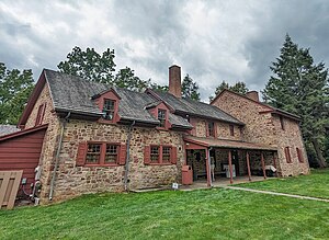
Moland House
Historic house in Pennsylvania, United States
Distance: Approx. 3806 meters
Latitude and longitude: 40.23611111,-75.09277778
Moland House (also known as Washington's Headquarters Farm) is an old stone farmhouse built around 1750, by John Moland (b. 1700 London, England d. 1761), a Philadelphia and Bucks County lawyer.
Jamison, Pennsylvania
Village in Pennsylvania, United States
Distance: Approx. 3842 meters
Latitude and longitude: 40.25472222,-75.08944444
Jamison is a small village in Warwick Township, Bucks County, Pennsylvania, United States, along Pennsylvania Route 263. Its ZIP Code is 18929. Jamison Elementary School of the Central Bucks School District is located in Jamison.

Fretz Farm
United States historic place
Distance: Approx. 2438 meters
Latitude and longitude: 40.27083333,-75.12888889
Fretz Farm was a historic house and farm complex located in Doylestown Township Township, Bucks County, Pennsylvania. It had five contributing buildings and one contributing structure. They were the farmhouse, barn, carriage house, small barn / corn crib, old barn, gazebo, and pump house.
Neshaminy, Pennsylvania
Unincorporated community in Pennsylvania, United States
Distance: Approx. 2247 meters
Latitude and longitude: 40.22944444,-75.13888889
Neshaminy is an unincorporated community in Warrington Township in Bucks County, Pennsylvania, United States. Neshaminy is located at the intersection of Pennsylvania Route 611 and Pennsylvania Route 132.

Hartsville, Pennsylvania
Populated place in Pennsylvania, United States
Distance: Approx. 4060 meters
Latitude and longitude: 40.22833333,-75.095
Hartsville is a populated place that is situated at the crossroads of Bristol Road and the Old York Road, and straddles Warminster and Warwick Township in Bucks County, Pennsylvania, United States. It has an estimated elevation of 427 feet (130 m) above sea level, and is served by the Warminster Post Office ZIP code of 18974.
Mill Creek (Neshaminy Creek tributary, Wrightstown Township)
River in Pennsylvania, United States
Distance: Approx. 3712 meters
Latitude and longitude: 40.275,-75.16194444
Mill Creek is a tributary of Neshaminy Creek, one of three tributaries of the Neshaminy which all share the same name, and one of six in Bucks County, Pennsylvania which share the name. The Geographic Name Information System I.D. is 1181118, U.S. Department of the Interior Geological Survey I.D. is 02596.

Park Creek (Little Neshaminy Creek tributary)
River in Pennsylvania, United States
Distance: Approx. 3028 meters
Latitude and longitude: 40.22333333,-75.14472222
Park Creek is a tributary of the Little Neshaminy Creek, part of the Delaware River Watershed meeting its confluence at the Little Neshaminy's 9.00 river mile.
Mill Creek (Neshaminy Creek tributary, Doylestown Township)
River in Pennsylvania, United States
Distance: Approx. 3712 meters
Latitude and longitude: 40.275,-75.16194444
Mill Creek is one of the three tributaries of the Neshaminy Creek bearing the name and one of six Mill Creeks in Bucks County, Pennsylvania. Rising in Doylestown Township, Mill Creek runs about 2 miles (3.2 km) to its confluence at Neshaminy Creek's 36.40 river mile.
Weather in this IP's area
broken clouds
22 Celsius
22 Celsius
21 Celsius
23 Celsius
1010 hPa
58 %
1010 hPa
996 hPa
10000 meters
4.63 m/s
330 degree
75 %
07:03:13
18:32:55