Country:
Region:
City:
Latitude and Longitude:
Time Zone:
Postal Code:
IP information under different IP Channel
ip-api
Country
Region
City
ASN
Time Zone
ISP
Blacklist
Proxy
Latitude
Longitude
Postal
Route
Luminati
Country
ASN
Time Zone
America/Chicago
ISP
INTERNAP-BLK3
Latitude
Longitude
Postal
IPinfo
Country
Region
City
ASN
Time Zone
ISP
Blacklist
Proxy
Latitude
Longitude
Postal
Route
db-ip
Country
Region
City
ASN
Time Zone
ISP
Blacklist
Proxy
Latitude
Longitude
Postal
Route
ipdata
Country
Region
City
ASN
Time Zone
ISP
Blacklist
Proxy
Latitude
Longitude
Postal
Route
Popular places and events near this IP address

Midtown, Houston
Neighborhood of Houston in Harris County, Texas, USA
Distance: Approx. 673 meters
Latitude and longitude: 29.742,-95.374
Midtown is a central neighborhood of Houston, located west-southwest of Downtown. Separated from Downtown by an elevated section of Interstate 45 (the Pierce Elevated), Midtown is characterized by a continuation of Downtown's square grid street plan, anchored by Main Street and the METRORail Red Line. Midtown is bordered by Neartown (Montrose) to the west, the Museum District to the south, and Interstate 69 to the east.

Houston tunnel system
System of pedestrian tunnels in Houston, US
Distance: Approx. 723 meters
Latitude and longitude: 29.75,-95.37
The Houston tunnel system is a network of subterranean, climate-controlled, pedestrian walkways that links 95 full city blocks 20 feet (6 m) below Houston's downtown streets. It is approximately six miles (9.7 km) long. There are similar systems in Chicago, Dallas, Oklahoma City, Montreal, and Toronto.

McGowen station
Light rail station in Houston, Texas
Distance: Approx. 356 meters
Latitude and longitude: 29.74576667,-95.37380556
McGowen is an island platformed METRORail light rail station in Houston, Texas, United States. The station was opened on January 1, 2004 and is operated by the Metropolitan Transit Authority of Harris County, Texas (METRO). Located in Midtown, this station is at the intersection of Main Street and McGowen Street.
Houston Community College System Foundation
Distance: Approx. 612 meters
Latitude and longitude: 29.742,-95.3768
The Houston Community College System Foundation was founded in 1976 to provide scholarships to Houston Community College students and to support the college's efforts to attract and educate Houston-area students—including many non-traditional students and those facing barriers to higher education. Like virtually all community college foundations, for most of its existence the HCCS Foundation functioned primarily as a clearinghouse for scholarships, accepting funds from donors and awarding them to eligible students. It was not expected to engage in large-scale solicitation of funds.
Herald Park
Baseball park in Houston, Texas
Distance: Approx. 218 meters
Latitude and longitude: 29.7459,-95.3756
Herald Park (also known as Houston Base Ball Park, Fair Ground Park, and League Park) was a baseball park located in Houston, Texas and was the home of the Houston Buffaloes from 1888 until 1904. It also served as the spring training facility for the Louisville Colonels and the St. Louis Cardinals in the National League of Major League Baseball in 1895 and 1904 respectively.

Cullen Center
Building complex in Houston, Texas, U.S.
Distance: Approx. 719 meters
Latitude and longitude: 29.753,-95.373
Cullen Center is a skyscraper complex in Downtown Houston, Texas, United States. The complex is now managed by Brookfield Properties. Previously Trizec Properties owned all four office buildings.

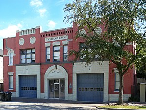
Houston Fire Museum
Distance: Approx. 203 meters
Latitude and longitude: 29.7474,-95.3748
The Houston Fire Museum, also known as the Fire Museum of Houston, is located in the Midtown District of Houston, Texas. The museum contains interactive exhibits and displays featuring antique and modern firefighting paraphernalia. The museum also educates its visitors in fire safety and prevention and is considered to be one of the finest centers of its kind in Texas.

Houston Fire Station No. 7
United States historic place
Distance: Approx. 203 meters
Latitude and longitude: 29.74741667,-95.37480556
Houston Fire Station No. 7 is a historic fire station located at 2403 Milam Street in Houston, Texas. It was listed on the National Register of Historic Places on April 17, 1986.
Brazos River Bottom
Distance: Approx. 204 meters
Latitude and longitude: 29.74914,-95.377831
Brazos River Bottom, also known as the BRB, was a gay bar located in the Midtown, Houston, Texas, United States, that opened in 1978. At the time of its closure in 2013, it was one of Houston's oldest gay bars, and the oldest still running at its original location.
Meteor (bar)
Defunct gay bar and nightclub in Houston, Texas, U.S.
Distance: Approx. 719 meters
Latitude and longitude: 29.748596,-95.384236
Meteor, also known as Meteor Houston, Meteor Nightclub, or Meteor Urban Video Lounge, was a gay bar and nightclub in Neartown, Houston, Texas, in the United States. The bar hosted an annual Mr. Gay Pride Houston competition.

James L. Autry House (Courtlandt Place, Houston)
Historic house in Houston, Texas
Distance: Approx. 703 meters
Latitude and longitude: 29.743,-95.382
James L. Autry House is located at 5 Courtlandt Place in Houston, Texas, and is listed on the National Register of Historic Places. Design is credited to Alfred C. Finn, when he worked for the Fort Worth architecture firm of Sanguinet & Staats, and was executed in 1912. Autry was a general counsel and director for Texaco.

Benjamin Apartments
Historic apartment building in Houston, Texas
Distance: Approx. 705 meters
Latitude and longitude: 29.74638889,-95.36972222
The Benjamin Apartments is a building in Midtown, Houston listed on the National Register of Historic Places. It was designed by local architect, Alfred C. Finn, and completed in 1924. It was first an owner-occupied four-plex.
Weather in this IP's area
mist
23 Celsius
23 Celsius
21 Celsius
24 Celsius
1011 hPa
85 %
1011 hPa
1010 hPa
8047 meters
4.63 m/s
7.2 m/s
130 degree
100 %
06:48:24
17:25:04