Country:
 USA
USARegion:
City:
Latitude and Longitude:
Time Zone:
Postal Code:
IP information under different IP Channel
ip-api
Country
Region
City
ASN
Time Zone
ISP
Blacklist
Proxy
Latitude
Longitude
Postal
Route
IPinfo
Country
Region
City
ASN
Time Zone
ISP
Blacklist
Proxy
Latitude
Longitude
Postal
Route
MaxMind
Country
Region
City
ASN
Time Zone
ISP
Blacklist
Proxy
Latitude
Longitude
Postal
Route
Luminati
Country
USASN
Time Zone
America/Chicago
ISP
INTERNAP-2BLK
Latitude
Longitude
Postal
db-ip
Country
Region
City
ASN
Time Zone
ISP
Blacklist
Proxy
Latitude
Longitude
Postal
Route
ipdata
Country
Region
City
ASN
Time Zone
ISP
Blacklist
Proxy
Latitude
Longitude
Postal
Route
Popular places and events near this IP address

One Federal Street
Office in Boston, Massachusetts, United States
Distance: Approx. 97 meters
Latitude and longitude: 42.356564,-71.056963
One Federal Street is a skyscraper in the Financial District neighborhood of Boston, Massachusetts. Completed in 1975, it is Boston's 15th-tallest building, standing 520 feet (159 m) tall, and housing 38 floors. It is very close to the Rose F. Kennedy Greenway, Faneuil Hall Marketplace.

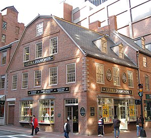
Old South Meeting House
Historic church in Boston, Massachusetts
Distance: Approx. 45 meters
Latitude and longitude: 42.35694444,-71.05861111
The Old South Meeting House is a historic Congregational church building located at the corner of Milk and Washington Streets in the Downtown Crossing area of Boston, Massachusetts, built in 1729. It gained fame as the organizing point for the Boston Tea Party on December 16, 1773. Five thousand or more colonists gathered at the Meeting House, the largest building in Boston at the time.
Dollars & Sense
Distance: Approx. 39 meters
Latitude and longitude: 42.35671667,-71.05856111
Dollars & Sense is a magazine focusing on economics from a progressive perspective, published by Dollars & Sense, Inc, which also publishes textbooks in the same genre. Dollars & Sense describes itself as publishing "economic news and analysis, reports on economic justice activism, primers on economic topics, and critiques of the mainstream media's coverage of the economy." Published since 1974 (it was originally a monthly; now it is bimonthly), it is edited by a collective of economists, journalists, and activists committed to the ideals of social justice and economic democracy. It was initially sponsored by the Union for Radical Political Economics, but it is no longer affiliated with that organization.
Old Corner Bookstore
United States historic place
Distance: Approx. 101 meters
Latitude and longitude: 42.3575,-71.05888889
The Old Corner Bookstore is a historic commercial building located at 283 Washington Street at the corner of School Street in the historic core of Boston, Massachusetts. It was built in 1718 as a residence and apothecary shop, and first became a bookstore in 1828. The building is a designated site on Boston's Freedom Trail, Literary Trail, and Women's Heritage Trail.

Winthrop Building
United States historic place
Distance: Approx. 78 meters
Latitude and longitude: 42.3575,-71.05805556
The Winthrop Building is an historic skyscraper at 7 Water Street (intersection with Washington Street) in Boston, Massachusetts. The nine-story brick-and-terracotta building was designed by Clarence H. Blackall in the Renaissance Revival style, and has the distinction of being the first skyscraper in the city to have been constructed with a steel frame. Completed in 1894, it was originally known as the Carter Building, but was renamed the Winthrop Building in 1899 after the Puritan Governor John Winthrop, whose second house was located adjacent to the site.

Newspaper Row (Boston)
United States historic place
Distance: Approx. 89 meters
Latitude and longitude: 42.35666667,-71.05916667
Newspaper Row is now a historic district at 322-328 Washington Street, 5-23 Milk Street, and 11 Hawley Street in Boston, Massachusetts.

International Trust Company Building
United States historic place
Distance: Approx. 46 meters
Latitude and longitude: 42.35638889,-71.05805556
The International Trust Company Building is an historic office building at 39-47 Milk Street in Boston, Massachusetts. The nine-story masonry-clad building was built in 1892–93 to a design by William Gibbons Preston. It is an early Boston example of the Beaux Arts style, and is structurally an early prototype of the use of skeleton framing.

Compton Building
United States historic place
Distance: Approx. 77 meters
Latitude and longitude: 42.35622222,-71.05758333
The Compton Building is a historic building at 159, 161-175 Devonshire Street and 18-20 Arch Street in Boston, Massachusetts. The eleven-story Classical Revival office tower was built in 1902–03 to a design by Henry Forbes Bigelow of Winslow & Bigelow. It was connected by internal connections to the adjacent International Trust Company Building in 1961, when the two buildings were under common ownership.

Hawley Street (Boston)
Street in Boston, Massachusetts, U.S.
Distance: Approx. 68 meters
Latitude and longitude: 42.35619722,-71.05826111
Hawley Street of Boston, Massachusetts, is located in the Financial District between Milk and Summer Streets. Prior to 1799, it was called Bishop's Alley and briefly in the 1790s Board Alley.
Board Alley Theatre
Distance: Approx. 68 meters
Latitude and longitude: 42.35619722,-71.05826111
The Board Alley Theatre (1792–1793) was an illegal theatre in Boston, Massachusetts in the late 18th century. Also called the New Exhibition Room, it was located in Board Alley in the Financial District. Although some in town supported the theatre, others vehemently opposed it.

Great Boston fire of 1760
Fire which destroyed much of downtown Boston, Massachusetts
Distance: Approx. 82 meters
Latitude and longitude: 42.3575,-71.0584
The Great Boston fire of 1760 was a major conflagration that occurred on March 20, 1760, in Boston in the Province of Massachusetts. The fire destroyed 349 buildings in the area between the modern Washington Street and Fort Hill, as well as several ships in port, and it left more than a thousand people homeless.

Boston Irish Famine Memorial
Sculpture in Boston, Massachusetts, U.S.
Distance: Approx. 73 meters
Latitude and longitude: 42.357324,-71.058641
The Boston Irish Famine Memorial is a memorial park located on a plaza between Washington Street and School Street in Boston, Massachusetts. The park contains two groups of statues to contrast an Irish family suffering during the Great Famine of 1845–1852 with a prosperous family that had immigrated to America. Funded by a trust led by Boston businessman Thomas Flatley, the park was opened in 1998.
Weather in this IP's area
clear sky
11 Celsius
11 Celsius
10 Celsius
13 Celsius
1012 hPa
84 %
1012 hPa
1011 hPa
10000 meters
0.89 m/s
2.24 m/s
291 degree
7 %
06:17:24
19:06:27