Country:
 USA
USARegion:
City:
Latitude and Longitude:
Time Zone:
Postal Code:
IP information under different IP Channel
ip-api
Country
Region
City
ASN
Time Zone
ISP
Blacklist
Proxy
Latitude
Longitude
Postal
Route
IPinfo
Country
Region
City
ASN
Time Zone
ISP
Blacklist
Proxy
Latitude
Longitude
Postal
Route
MaxMind
Country
Region
City
ASN
Time Zone
ISP
Blacklist
Proxy
Latitude
Longitude
Postal
Route
Luminati
Country
USASN
Time Zone
America/Chicago
ISP
INTERNAP-2BLK
Latitude
Longitude
Postal
db-ip
Country
Region
City
ASN
Time Zone
ISP
Blacklist
Proxy
Latitude
Longitude
Postal
Route
ipdata
Country
Region
City
ASN
Time Zone
ISP
Blacklist
Proxy
Latitude
Longitude
Postal
Route
Popular places and events near this IP address
The Boston Globe
American daily newspaper
Distance: Approx. 72 meters
Latitude and longitude: 42.35833333,-71.05583333
The Boston Globe, also known locally as the Globe, is an American daily newspaper founded and based in Boston, Massachusetts. The newspaper has won a total of 27 Pulitzer Prizes. The Globe is available in print and online.

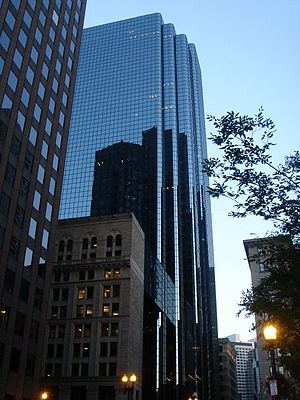
60 State Street
Office in Boston, Massachusetts
Distance: Approx. 88 meters
Latitude and longitude: 42.35903,-71.05646
60 State Street is a modern skyscraper on historic State Street in the Government Center neighborhood of Boston, Massachusetts. Completed in 1977, it is Boston's 19th tallest building, standing 509 feet (155 m) tall, and housing 38 floors [1][usurped].
Exchange Place (Boston)
Skyscraper in Boston
Distance: Approx. 108 meters
Latitude and longitude: 42.35832,-71.05645
Exchange Place is a modern skyscraper located at the block of 43–53 State Street or 1 Exchange Place, between Congress and Kilby Streets, in the Financial District of Boston, Massachusetts. Built in 1981–1985, it is tied for Boston's 17th tallest building, standing 510 feet (155 m) tall, and containing 40 floors. The glass tower portion rises out of a previous building, the 12-story Boston Stock Exchange, built in 1889–1891 and designed by Peabody and Stearns.
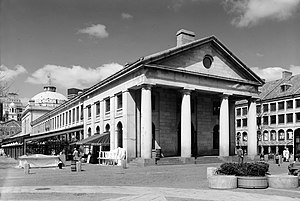
Quincy Market
Historic landmark in Boston, US
Distance: Approx. 127 meters
Latitude and longitude: 42.36,-71.055
Quincy Market is a historic building near Faneuil Hall in downtown Boston, Massachusetts. It was constructed between 1824 and 1826 and named in honor of mayor Josiah Quincy, who organized its construction without any tax or debt. The market is a designated National Historic Landmark and a designated Boston Landmark in 1996, significant as one of the largest market complexes built in the United States in the first half of the 19th century.

State Street (Boston)
Distance: Approx. 126 meters
Latitude and longitude: 42.35887778,-71.05693056
State Street is one of the oldest and most historic streets in Boston, Massachusetts, United States. Located in the financial district, it is the site of some historic landmarks, such as Long Wharf, the Old State House and the Boston Custom House.

Bunch-of-Grapes
Former tavern located in Boston, Massachusetts, United States
Distance: Approx. 39 meters
Latitude and longitude: 42.35897222,-71.05585833
The Bunch-of-Grapes was a tavern located on King Street (State Street) in Boston in the Province of Massachusetts Bay in the 17th and 18th centuries. It served multiple functions in the life of the town, as one could buy drinks and meet friends, business associates, political co-conspirators.

Merchants Exchange (Boston)
Distance: Approx. 75 meters
Latitude and longitude: 42.35870278,-71.05626667
The Merchants Exchange building (1842-1890) in Boston, Massachusetts was built in 1841 from a design by architect Isaiah Rogers. Centrally located on State Street, it functioned as a hub for business activities in the city.

Merchants Row (Boston)
Distance: Approx. 71 meters
Latitude and longitude: 42.35949444,-71.05570833
Merchants Row in Boston, Massachusetts, is a short street extending from State Street to Faneuil Hall Square in the Financial District. Since the 17th century, it has been a place of commercial activity. It sits close to Long Wharf and Dock Square, hubs of shipping and trade through the 19th century.

75 State Street
Office in Boston, Massachusetts
Distance: Approx. 51 meters
Latitude and longitude: 42.358512,-71.055077
75 State Street is a high-rise office building located in the Financial District of Boston. Built in 1988, it was designed by Gund Architects of Boston, in association with Skidmore, Owings and Merrill, in the Postmodernist style. The 31-story building rises to a height of 118.9 metres (390 ft), and has a floor area of 93,088 square metres (1,001,990 sq ft).

Boston Evening Traveller
Massachusetts daily newspaper (1845–1967)
Distance: Approx. 125 meters
Latitude and longitude: 42.35879722,-71.05690833
The Boston Evening Traveller (1845–1967) was a newspaper published in Boston, Massachusetts. It was a daily newspaper, with weekly and semi-weekly editions under a variety of Traveller titles. It was absorbed by the Boston Herald in 1912, and ceased publication in 1967.

Hungarian Revolution Memorial
Sculpture in Boston, Massachusetts, U.S.
Distance: Approx. 111 meters
Latitude and longitude: 42.35791,-71.05529
The Hungarian Revolution Memorial (also known as Hungarian Monument) is a monument and sculpture by E. Gyuri Hollosy, installed in Boston's Liberty Square Park, in the U.S. state of Massachusetts. It commemorates the thirtieth anniversary of the Hungarian Revolution of 1956.

Fiske Building
Demolished skyscraper in Boston, Massachusetts, USA
Distance: Approx. 10 meters
Latitude and longitude: 42.35895,-71.0553
The Fiske Building, located in Boston, was a 38.1 m (125 ft) skyscraper built by Peabody and Stearns in 1888 and demolished in 1986. In 1964, five stories were added to the building, and the facade was altered with the addition of glass, black aluminum strips and horizontal blue panels, leading architectural observers to describe the building as one of the ugliest in Boston.
Weather in this IP's area
clear sky
11 Celsius
11 Celsius
10 Celsius
13 Celsius
1012 hPa
84 %
1012 hPa
1012 hPa
10000 meters
0.89 m/s
2.24 m/s
291 degree
7 %
06:17:24
19:06:26