Country:
Region:
City:
Latitude and Longitude:
Time Zone:
Postal Code:
IP information under different IP Channel
ip-api
Country
Region
City
ASN
Time Zone
ISP
Blacklist
Proxy
Latitude
Longitude
Postal
Route
Luminati
Country
ASN
Time Zone
America/Chicago
ISP
INTERNAP-BLK3
Latitude
Longitude
Postal
IPinfo
Country
Region
City
ASN
Time Zone
ISP
Blacklist
Proxy
Latitude
Longitude
Postal
Route
db-ip
Country
Region
City
ASN
Time Zone
ISP
Blacklist
Proxy
Latitude
Longitude
Postal
Route
ipdata
Country
Region
City
ASN
Time Zone
ISP
Blacklist
Proxy
Latitude
Longitude
Postal
Route
Popular places and events near this IP address

Westin Bonaventure Hotel
Hotel in Los Angeles, California (opened 1976)
Distance: Approx. 178 meters
Latitude and longitude: 34.052778,-118.255833
The Westin Bonaventure Hotel and Suites is a 367-foot (112 m), 33-story hotel in Los Angeles, California, constructed between 1974 and 1977. It was designed by architect John C. Portman Jr.. The top floor has a revolving restaurant and bar.
Richfield Tower
1929 building was the headquarters of Richfield Oil in Los Angeles
Distance: Approx. 78 meters
Latitude and longitude: 34.050799,-118.256966
Richfield Tower, also known as the Richfield Oil Company Building, was an office tower constructed between 1928 and 1929 and served as the headquarters of Richfield Oil in Los Angeles, California.
California Club
United States historic place
Distance: Approx. 146 meters
Latitude and longitude: 34.05027778,-118.25641667
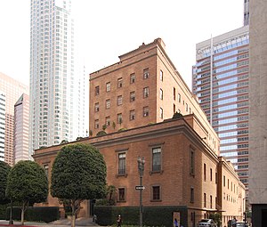
The California Club is an invitation-only private club established in 1888, based in Los Angeles, California. According to the Los Angeles Times, "The people who run Los Angeles belong to the Jonathan Club; the people who own Los Angeles belong to the California Club." The California Club maintains a mandatory requirement that all new member candidates wishing to gain entry must receive invitations from no less than six existing club members, pass a series of interviews by the club's membership committee, and undergo additional background and reference checks in order to obtain admission. In April 2005, the club was ranked #13 in the "Centrality Rankings" by UC Santa Cruz sociologist G. William Domhoff in his research about social clubs, policy-planning groups, corporations, and ruling-class cohesiveness.

Jonathan Club
Southern California social club
Distance: Approx. 138 meters
Latitude and longitude: 34.051517,-118.258498
Jonathan Club is a social club with two California locations—one in Downtown Los Angeles and the other abutting the beach in Santa Monica. The club is routinely ranked as one of the top clubs in the world by Platinum Clubs of America.

Union Bank Plaza
Historic building in Los Angeles, California
Distance: Approx. 168 meters
Latitude and longitude: 34.053,-118.2572
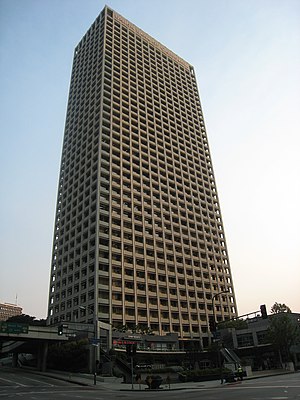
Union Bank Plaza is a Los Angeles Historic-Cultural Monument listed 40-story, 157 m (515 ft) office skyscraper located on South Figueroa Street in Downtown Los Angeles, California.

City National Plaza
Skyscraper in Los Angeles
Distance: Approx. 78 meters
Latitude and longitude: 34.0508,-118.2569
City National Plaza is a twin tower skyscraper complex on South Flower Street in western Downtown Los Angeles, California, United States. It was originally named ARCO Plaza upon opening in 1972.

FourFortyFour South Flower
48-story skyscraper at 444 South Flower Street in Bunker Hill area of downtown Los Angeles
Distance: Approx. 180 meters
Latitude and longitude: 34.051612,-118.25505
FourFortyFour South Flower, formerly Citigroup Center, is a 627 ft (191 m) 48-story skyscraper at 444 South Flower Street in the Bunker Hill area of downtown Los Angeles, California. At the time of its completion, in 1981, the tower was the fifth-tallest in the city.
Superior Oil Company Building
United States historic place
Distance: Approx. 159 meters
Latitude and longitude: 34.05027778,-118.25611111
The Delphi Hotel is a 12-story hotel located at 550 S Flower St in Downtown Los Angeles in the marble-clad high-rise Superior Oil Company Building formerly the headquarters of the now defunct company, converted to The Standard Downtown LA hotel in 2002, then closed in 2020 and reopened in 2023 under its current name.
ARCO Center for Visual Art
Distance: Approx. 13 meters
Latitude and longitude: 34.05138889,-118.25694444
The ARCO Center for Visual Art was a not-for-profit gallery, funded by the Atlantic Richfield Company in Los Angeles, California. It opened in 1976 and closed in 1984. The gallery focused on contemporary art.

Double Ascension
Public sculpture
Distance: Approx. 48 meters
Latitude and longitude: 34.051086,-118.257132
Double Ascension is a public art installation by Herbert Bayer consisting of an abstract sculpture and fountain. Measuring 14.5-by-33-foot (4.4 by 10.1 m) long, with individual steps measuring 35 in (89 cm) by 11 ft (3.4 m) by 9 in (23 cm), the sculpture is fabricated in painted steel and mounted within a 60-foot (18 m) diameter pool. It is located in City National Plaza at 515 South Flower Street, Bunker Hill, Los Angeles, California, United States.

Maguire Gardens
Park in Los Angeles, California, U.S.
Distance: Approx. 93 meters
Latitude and longitude: 34.05111111,-118.25611111
Maguire Gardens is a 2.3-acre park in Los Angeles, California, United States. Adjacent to the Richard J. Riordan Central Library, the park is named after Robert Maguire.

Shoshone (sculpture)
Sculpture by Mark di Suvero in Los Angeles, California, U.S.
Distance: Approx. 156 meters
Latitude and longitude: 34.05191667,-118.25538889
Shoshone is a 1981–1982 steel sculpture by Mark di Suvero, installed in Bunker Hill, Los Angeles, in the U.S. state of California.
Weather in this IP's area
clear sky
11 Celsius
10 Celsius
9 Celsius
14 Celsius
1014 hPa
42 %
1014 hPa
1005 hPa
10000 meters
4.12 m/s
300 degree
06:28:14
16:48:18

