70.40.69.130 - IP Lookup: Free IP Address Lookup, Postal Code Lookup, IP Location Lookup, IP ASN, Public IP
Country:
 USA
USARegion:
City:
Location:
Time Zone:
Postal Code:
ISP:
ASN:
language:
User-Agent:
Proxy IP:
Blacklist:
IP information under different IP Channel
ip-api
Country
Region
City
ASN
Time Zone
ISP
Blacklist
Proxy
Latitude
Longitude
Postal
Route
db-ip
Country
Region
City
ASN
Time Zone
ISP
Blacklist
Proxy
Latitude
Longitude
Postal
Route
IPinfo
Country
Region
City
ASN
Time Zone
ISP
Blacklist
Proxy
Latitude
Longitude
Postal
Route
IP2Location
70.40.69.130Country
usRegion
north carolina
City
calabash
Time Zone
America/New_York
ISP
Language
User-Agent
Latitude
Longitude
Postal
ipdata
Country
Region
City
ASN
Time Zone
ISP
Blacklist
Proxy
Latitude
Longitude
Postal
Route
Popular places and events near this IP address

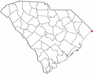
Calabash, North Carolina
Town in North Carolina, United States
Distance: Approx. 2282 meters
Latitude and longitude: 33.89527778,-78.55138889
Calabash is a small fishing town in Brunswick County, North Carolina, United States. As of the 2020 census, the population of the town was 2,011. It is known as the "Seafood Capital of the World" because of the town's seafood restaurants.
Carolina Shores, North Carolina
Town in North Carolina, United States
Distance: Approx. 580 meters
Latitude and longitude: 33.90888889,-78.57444444
Carolina Shores is a town in Brunswick County, North Carolina, United States. The population was 3,048 at the 2010 census, up from 1,482 in 2000. It is part of the Wilmington, NC Metropolitan Statistical Area.

Sunset Beach, North Carolina
Town in North Carolina, United States
Distance: Approx. 8202 meters
Latitude and longitude: 33.87277778,-78.49333333
Sunset Beach is a seaside town in Brunswick County, North Carolina, United States. The population was 3,572 at the 2010 census, up from 1,824 in 2000 census. It is part of the Wilmington, NC Metropolitan Statistical Area and the southernmost beach in the state.
Little River, South Carolina
CDP in South Carolina, United States
Distance: Approx. 6124 meters
Latitude and longitude: 33.87166667,-78.62777778
Little River is a census-designated place (CDP) in Horry County, South Carolina, United States. The population was 11,711 at the 2020 census. Little River is named for the Little River, which flows into the Atlantic Ocean at the state line between North Carolina and South Carolina.
Little River (Horry County, South Carolina)
River in Horry County, South Carolina, United States of America
Distance: Approx. 6907 meters
Latitude and longitude: 33.84583333,-78.54694444
The Little River flows through Little River, South Carolina, briefly touching the border with North Carolina before emptying into the Atlantic Ocean at the Little River Inlet. A large portion of the river forms part of the Atlantic Intracoastal Waterway. Due to USGS weather buoy off Little River Inlet, the Little River Inlet is often referred to in weather forecasts.

Bird Island, North Carolina
Distance: Approx. 6116 meters
Latitude and longitude: 33.85722222,-78.53861111
Bird Island is approximately 1,300 acres (5.3 km2) adjacent to the town of Sunset Beach, North Carolina, US. Sunset Beach is on a barrier island and is the southernmost town in North Carolina. Bird Island can be reached by walking along the seashore toward the South Carolina border. Due to the contour of the Atlantic Coast at this point, the direction of travel to Bird Island is approximately West-Southwest.

Waties Island, South Carolina
Distance: Approx. 6102 meters
Latitude and longitude: 33.84888889,-78.57472222
Waties Island is an undeveloped barrier island in the eastern coast of South Carolina. It is under the jurisdiction of Coastal Carolina University and is used primarily as an educational research facility.
WNMI-LP
Radio station in North Myrtle Beach, South Carolina
Distance: Approx. 5226 meters
Latitude and longitude: 33.87555556,-78.61916667
WNMI-LP (98.7 FM) was a low-power radio station broadcasting a News Talk Information format. Formerly licensed to North Myrtle Beach, South Carolina, United States, the station was owned by City of North Myrtle Beach. The station's license was surrendered to the Federal Communications Commission (FCC) by the licensee on February 20, 2013, and the license was then cancelled by the FCC on February 22, 2013.
North Myrtle Beach High School
Public high school in Little River, South Carolina, United States
Distance: Approx. 9822 meters
Latitude and longitude: 33.86277778,-78.66805556
North Myrtle Beach High School is a public school located in Little River, South Carolina. The school is one of nine high schools within Horry County Schools. The school serves the city of North Myrtle Beach, the town of Atlantic Beach, and the communities of Little River and Longs.
1977 LPGA Championship
Golf tournament
Distance: Approx. 8788 meters
Latitude and longitude: 33.872,-78.661
The 1977 LPGA Championship was the 23rd LPGA Championship, played June 9–12, 1977 at the Gold Course of Bay Tree Golf Plantation in North Myrtle Beach, South Carolina. Chako Higuchi won her only major title, three strokes ahead of runners-up Pat Bradley, Sandra Post, and Judy Rankin. The purse was nearly tripled this year to $150,000, up from $55,000 in 1976.
Weather in this IP's area
broken clouds
9 Celsius
6 Celsius
8 Celsius
10 Celsius
1028 hPa
74 %
1028 hPa
1028 hPa
10000 meters
4.63 m/s
30 degree
75 %