Country:
Region:
City:
Latitude and Longitude:
Time Zone:
Postal Code:
IP information under different IP Channel
ip-api
Country
Region
City
ASN
Time Zone
ISP
Blacklist
Proxy
Latitude
Longitude
Postal
Route
Luminati
Country
Region
ca
City
dalycity
ASN
Time Zone
America/Los_Angeles
ISP
AS-SONICTELECOM
Latitude
Longitude
Postal
IPinfo
Country
Region
City
ASN
Time Zone
ISP
Blacklist
Proxy
Latitude
Longitude
Postal
Route
db-ip
Country
Region
City
ASN
Time Zone
ISP
Blacklist
Proxy
Latitude
Longitude
Postal
Route
ipdata
Country
Region
City
ASN
Time Zone
ISP
Blacklist
Proxy
Latitude
Longitude
Postal
Route
Popular places and events near this IP address

Broadmoor, California
Unincorporated community in California, United States
Distance: Approx. 1278 meters
Latitude and longitude: 37.6925,-122.47888889
Broadmoor is a census-designated place (CDP) in an unincorporated area of San Mateo County, California, United States. The enclave is entirely surrounded by Daly City. The population was 4,176 at the 2010 census.

Daly City, California
City in California, United States
Distance: Approx. 1231 meters
Latitude and longitude: 37.68638889,-122.46833333
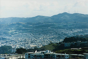
Daly City () is the second most populous city in San Mateo County, California, United States. Located in the San Francisco Bay Area, and immediately south of San Francisco (sharing its northern border with almost all of San Francisco's southern border), it is named for businessman and landowner John Donald Daly. The population was 104,901 at the 2020 census.

Congregation B'nai Israel (Daly City, California)
Karaite Jewish synagogue in Daly City, California, US
Distance: Approx. 957 meters
Latitude and longitude: 37.68847,-122.475
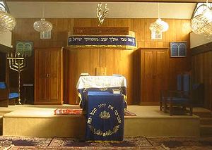
Congregation B'nai Israel is a Karaite Jewish congregation and synagogue, located at 1575 Annie Street, in Daly City, in the San Francisco Bay Area, in California in the United States. It is the only Karaite congregation in the United States. The synagogue building was purchased in 1995 from a former Orthodox congregation called B'ai Israel.

Westmoor High School
Public high school in Daly City, California, US
Distance: Approx. 303 meters
Latitude and longitude: 37.683396,-122.482442
Westmoor High School is a public high school in Daly City, California, United States. It serves grades 9 through 12 as part of the Jefferson Union High School District (JUHSD). It generally serves the residents of Daly City, Pacifica, and Colma.
Jefferson Union High School District
School district in California, United States
Distance: Approx. 1459 meters
Latitude and longitude: 37.668096,-122.478551
The Jefferson Union High School District (JUHSD) is a high school district in northern San Mateo County, California, which serves the cities of Daly City, Brisbane and Pacifica, the town of Colma, the CDP of Broadmoor and a section of San Bruno. Its district office is located at the new location of 123 Edgemont Drive, Bldg. A, Daly City.

Colma station
Rapid transit station in Colma, California, US
Distance: Approx. 1339 meters
Latitude and longitude: 37.68472222,-122.46611111
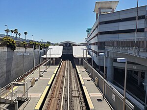
Colma station is a Bay Area Rapid Transit (BART) station located in unincorporated northern San Mateo County, California adjacent to the incorporated town of Colma and city of Daly City. The station is served by the Red and Yellow lines. Colma station is situated in a small valley shared with BART's Daly City Yard and a large parking garage.

Serramonte
Distance: Approx. 1684 meters
Latitude and longitude: 37.668858,-122.469363
Serramonte is a large 1960s residential neighborhood on the border of Daly City and Colma in the suburbs south of San Francisco, California, that is also home to numerous shopping malls, strip malls, and big box retailers. The neighborhood was developed beginning in 1963 by Fred and Carl Gellert's Suburban Realty Company on a former dairy ranch. Serramonte High School, built in 1970 and closed in 1981, was at one time one of the largest schools by enrollment in Daly City.

Serramonte Center
Shopping mall in California, United States
Distance: Approx. 1361 meters
Latitude and longitude: 37.672136,-122.470093
Serramonte Center is a 1,139,906 sq ft (105,900.7 m2) super-regional shopping mall located at the intersection of California State Route 1 and Interstate 280 in Daly City, California. Opened in 1968, it is owned and managed by Regency Centers and is anchored by Macy's, Dick's Sporting Goods, and Target.
Junipero Serra Landfill
Solid waste disposal site in California, United States
Distance: Approx. 1247 meters
Latitude and longitude: 37.678,-122.467
The Junipero Serra Landfill was a solid waste disposal site in Colma, California, United States. The site was closed in 1983 and ultimately developed by commercial land uses, collectively known as the Metro Center. The original commercial use built on the closed landfill site was a Home Depot retail store and parking lot constructed over 1,348 piles, each driven approximately 160 ft (49 m) deep into the landfill (Bay Area Rapid Transit District, 2006).

Seton Medical Center
Hospital in California, United States
Distance: Approx. 545 meters
Latitude and longitude: 37.6799,-122.4746
Seton Medical Center (originally Mary's Help Hospital) is a 398-bed hospital owned by AHMC Healthcare. Founded in San Francisco, the current facility is located in Daly City, California, United States. It is the largest employer in Daly City and is credited in part with attracting the initial influx of Filipino immigrants to the city, which has the highest concentration of Filipinos in the U.S. Seton also operates Seton Coastside, a 116-bed skilled nursing facility with a 24-hour standby emergency department in Moss Beach.

Woodlawn Memorial Park (Colma, California)
Cemetery in San Mateo County, California
Distance: Approx. 1291 meters
Latitude and longitude: 37.6794,-122.4661
Woodlawn Memorial Park, also known as the Masonic Burial Ground, is a cemetery located at 1000 El Camino Real in Colma, California. It was established in 1905.

Greenlawn Memorial Park (Colma, California)
Cemetery in San Mateo County, California
Distance: Approx. 1583 meters
Latitude and longitude: 37.67733,-122.46328
Greenlawn Memorial Park, also known as the Odd Fellows Cemetery, is a private cemetery located at 1100 El Camino Real in Colma, California, United States. It was established in 1904. In 1933, after ongoing city litigation the Odd Fellows Cemetery in San Francisco, part of the Lone Mountain Cemetery complex, reinterred some 26,000 graves to Greenlawn Memorial Park.
Weather in this IP's area
haze
15 Celsius
14 Celsius
13 Celsius
17 Celsius
1022 hPa
69 %
1022 hPa
1007 hPa
10000 meters
4.63 m/s
270 degree
75 %
06:47:29
17:01:00