Country:
 USA
USARegion:
City:
Latitude and Longitude:
Time Zone:
Postal Code:
IP information under different IP Channel
ip-api
Country
Region
City
ASN
Time Zone
ISP
Blacklist
Proxy
Latitude
Longitude
Postal
Route
IPinfo
Country
Region
City
ASN
Time Zone
ISP
Blacklist
Proxy
Latitude
Longitude
Postal
Route
MaxMind
Country
Region
City
ASN
Time Zone
ISP
Blacklist
Proxy
Latitude
Longitude
Postal
Route
Luminati
Country
USRegion
ca
City
sonoma
ASN
Time Zone
America/Los_Angeles
ISP
AS-SONICTELECOM
Latitude
Longitude
Postal
db-ip
Country
Region
City
ASN
Time Zone
ISP
Blacklist
Proxy
Latitude
Longitude
Postal
Route
ipdata
Country
Region
City
ASN
Time Zone
ISP
Blacklist
Proxy
Latitude
Longitude
Postal
Route
Popular places and events near this IP address
Sonoma, California
City in California, United States
Distance: Approx. 1026 meters
Latitude and longitude: 38.28888889,-122.45888889
Sonoma () is a city in Sonoma County, California, United States, located in the North Bay region of the San Francisco Bay Area. Sonoma is one of the principal cities of California's Wine Country and the center of the Sonoma Valley AVA. Sonoma's population was 10,739 as of the 2020 census, while the Sonoma urban area had a population of 32,679. Sonoma is a popular tourist destination, owing to its Californian wineries, noted events like the Sonoma International Film Festival, and its historic center.

California Republic
Unrecognized breakaway state from Mexico, 1846
Distance: Approx. 1400 meters
Latitude and longitude: 38.2925,-122.4575
The California Republic (Spanish: República de California), or Bear Flag Republic, was an unrecognized breakaway state from Mexico, that for 25 days in 1846 militarily controlled an area north of San Francisco, in and around what is now Sonoma County in California. In June 1846, thirty-three American immigrants in Alta California who had entered without official permission rebelled against the Mexican department's government. Among their grievances were that they had not been allowed to buy or rent land and had been threatened with expulsion.
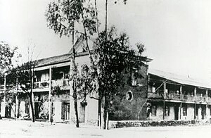
Sonoma Valley High School
Public school in the United States
Distance: Approx. 843 meters
Latitude and longitude: 38.28277778,-122.45805556
Sonoma Valley High School (SVHS) is a public high school located in Sonoma, California with approximately 1,300 students as of 2017. It was founded in 1891 and held its first commencement in 1894. It moved to its current campus in 1922.

Sonoma International Film Festival
Distance: Approx. 1385 meters
Latitude and longitude: 38.2916,-122.4565
Sonoma International Film Festival (SIFF) is a 501 (c)(3) non-profit arts organization, founded in 1997, headquartered in Sonoma, California.

Charles Creek Vineyard
Distance: Approx. 1312 meters
Latitude and longitude: 38.29243611,-122.45906111
Charles Creek Vineyard was a winery in Sonoma, California that specialized in Chardonnay and Cabernet Sauvignon wine and dessert wine.

Sonoma TrainTown Railroad
Tourist railroad and amusement park
Distance: Approx. 921 meters
Latitude and longitude: 38.2775,-122.4596
The Sonoma TrainTown Railroad (commonly called "Sonoma Train Town") is a tourist railroad and 10 acre amusement park in Sonoma, California. Its main feature is a 15 in (381 mm) gauge miniature railway, which closely corresponds to a 1:4 scale model of a 4 ft 8+1⁄2 in (1,435 mm) standard gauge railroad.
Sonoma Valley Hospital
Hospital in California, United States
Distance: Approx. 652 meters
Latitude and longitude: 38.2882,-122.4648
Sonoma Valley Hospital is a hospital located in Sonoma, California, United States. The hospital, which has 51 beds, provides surgical and general medical procedures. The hospital started in 1945 and the current hospital opened in 1957, with expansions happening starting in the 1970s.
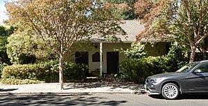
Nash-Patton Adobe
19th century adobe residence in California
Distance: Approx. 1271 meters
Latitude and longitude: 38.29046944,-122.45691944
The Nash-Patton Adobe (also called the Nash Adobe) is a historic house located in Sonoma, California in the United States. The home is listed as a California Historical Landmark.
Salvador Vallejo Adobe
Historic building in Sonoma, California
Distance: Approx. 1409 meters
Latitude and longitude: 38.29341667,-122.45892222
The Salvador Vallejo Adobe is a historic building located in Sonoma, California in the United States. The building is a California Historic Landmark.
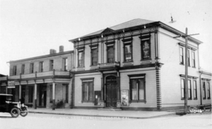
Union Hotel (Sonoma, California)
Historical place in Sonoma County, United States
Distance: Approx. 1276 meters
Latitude and longitude: 38.291855,-122.458747
Union Hotel and Union Hall Site is historical site of buildings built in 1850, in Sonoma, California in Sonoma County, California. The Union Hotel and Union Hall Site is a California Historical Landmark No. 627 listed on January 13, 1958.

Sonoma Valley Woman's Club
Woman's club in California
Distance: Approx. 1276 meters
Latitude and longitude: 38.29055556,-122.45694444
Sonoma Valley Woman's Club is a historic woman's clubhouse located in Sonoma, California. It was founded in 1901 by eleven local women led by Martha Stearns. Built in 1916, the club was designed by architect Brainerd Jones from Petaluma and plays a role in the civic development of Sonoma.
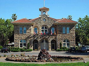
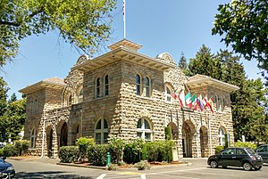
Sonoma City Hall
Historic building in Sonoma, California, U.S.
Distance: Approx. 1083 meters
Latitude and longitude: 38.28833333,-122.4575
Sonoma City Hall is a historic municipal government building located in the Sonoma Plaza in Sonoma, California. Dedicated on September 9, 1908, the building is the city's administrative center.
Weather in this IP's area
clear sky
25 Celsius
25 Celsius
19 Celsius
28 Celsius
1010 hPa
48 %
1010 hPa
1007 hPa
10000 meters
6.17 m/s
200 degree
06:55:31
19:11:28