Country:
Region:
City:
Latitude and Longitude:
Time Zone:
Postal Code:
IP information under different IP Channel
ip-api
Country
Region
City
ASN
Time Zone
ISP
Blacklist
Proxy
Latitude
Longitude
Postal
Route
Luminati
Country
Region
mn
City
annandale
ASN
Time Zone
America/Chicago
ISP
MIDCO-NET
Latitude
Longitude
Postal
IPinfo
Country
Region
City
ASN
Time Zone
ISP
Blacklist
Proxy
Latitude
Longitude
Postal
Route
db-ip
Country
Region
City
ASN
Time Zone
ISP
Blacklist
Proxy
Latitude
Longitude
Postal
Route
ipdata
Country
Region
City
ASN
Time Zone
ISP
Blacklist
Proxy
Latitude
Longitude
Postal
Route
Popular places and events near this IP address
Albion Township, Wright County, Minnesota
Township in Minnesota, United States
Distance: Approx. 8466 meters
Latitude and longitude: 45.19611111,-94.07222222
Albion Township is a township in Wright County, Minnesota, United States. The population was 1,146 at the 2000 census. Albion Township was organized in 1858, and named Albion, the archaic name for England.

Annandale, Minnesota
City in Minnesota, United States
Distance: Approx. 750 meters
Latitude and longitude: 45.26666667,-94.11666667
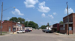
Annandale ( AN-ən-dayl) is a city in Wright County, Minnesota, United States. The population was 3,228 at the 2010 census. Annandale has been dubbed "The Heart of the Lakes" because it has 26 lakes within a 10-mile radius.
Corinna Township, Wright County, Minnesota
Township in Minnesota, United States
Distance: Approx. 5073 meters
Latitude and longitude: 45.28333333,-94.06666667
Corinna Township is a township in Wright County, Minnesota, United States. The population was 2,457 at the 2000 census. Corinna Township was organized in 1858, and named after Corinna, Maine.
South Haven, Minnesota
City in Minnesota, United States
Distance: Approx. 7618 meters
Latitude and longitude: 45.2925,-94.21194444
South Haven is a city in Wright County, Minnesota, United States. The population was 187 at the 2010 census. The official South Haven website can be found here.
Southside Township, Wright County, Minnesota
Township in Minnesota, United States
Distance: Approx. 6352 meters
Latitude and longitude: 45.28333333,-94.2
Southside Township is in Wright County, Minnesota, United States. The population was 1,576 at the 2000 census. Southside Township was organized in 1868.
Camp Courage
Distance: Approx. 5300 meters
Latitude and longitude: 45.2660764,-94.0569252
Camp Courage is a summer camp for children and adults with disabilities located in Maple Lake, Minnesota. A closely affiliated camp, Camp Courage North, is located near Bemidji, Minnesota. Until November 19, 2012, both camps were owned and operated by Courage Center, a disability advocacy organization.
You Can Run But You Cannot Hide International
Organization
Distance: Approx. 164 meters
Latitude and longitude: 45.26416667,-94.12416667
You Can Run But You Cannot Hide International (YCRBYCHI) was a United States Christian youth ministry that held assemblies (including music concerts and discussions with students) in public schools. YCRBYCHI's mission statement stated its goal was to "reshape America by re-directing the current and future generations both morally and spiritually through education, media, and the Judeo-Christian values found in our U.S. Constitution." The ministry received testimonials from school officials and students "that praise the positive impact the assemblies had by stressing the importance of good choices and using a band to grab attention." However, the ministry also attracted controversy for using public school assemblies for religious purposes. Detractors claim the ministry mislead school administrators about the nature of the program and proselytized its views on abortion and homosexuality.

St. Mark's Episcopal Chapel (Corinna Township, Minnesota)
Historic church in Minnesota, United States
Distance: Approx. 5533 meters
Latitude and longitude: 45.31077778,-94.1065
St. Mark's Episcopal Chapel is a small Gothic Revival chapel in Corinna Township, Minnesota, United States, built in 1871. It was listed on the National Register of Historic Places in 1979 for having local significance in the themes of architecture and religion.
West Albion, Minnesota
Unincorporated community in Minnesota, United States
Distance: Approx. 7490 meters
Latitude and longitude: 45.19583333,-94.135
West Albion is an unincorporated community in Wright County, Minnesota, United States. The community is located along Mitchell Avenue near Wright County Road 37. West Albion is located within Albion Township and French Lake Township.
French Lake, Minnesota
Unincorporated community in Minnesota, United States
Distance: Approx. 8468 meters
Latitude and longitude: 45.2,-94.18555556
French Lake is an unincorporated community in French Lake Township, Wright County, Minnesota, United States, near Annandale and Cokato. The community is located near the junction of Wright County Roads 3 and 37.

Thayer Hotel (Annandale, Minnesota)
United States historic place
Distance: Approx. 107 meters
Latitude and longitude: 45.26230556,-94.12563889
The Thayer Hotel is a historic hotel building in Annandale, Minnesota, United States, built in 1895. It was listed on the National Register of Historic Places in 1978 for its local significance in the theme of commerce. It was nominated as a significant example of the large, wood-frame hotels serving Wright County at the turn of the 20th century.
French Lake (Wright County, Minnesota)
Lake in the state of Minnesota, United States
Distance: Approx. 6655 meters
Latitude and longitude: 45.20888889,-94.16138889
French Lake is a lake in Wright County, in the U.S. state of Minnesota. A large share of the early settlers near the lake being French Canadians caused the name to be selected.
Weather in this IP's area
overcast clouds
8 Celsius
8 Celsius
7 Celsius
11 Celsius
1018 hPa
93 %
1018 hPa
979 hPa
10000 meters
100 %
07:15:44
16:46:54
