Country:
 USA
USARegion:
City:
Latitude and Longitude:
Time Zone:
Postal Code:
IP information under different IP Channel
ip-api
Country
Region
City
ASN
Time Zone
ISP
Blacklist
Proxy
Latitude
Longitude
Postal
Route
IPinfo
Country
Region
City
ASN
Time Zone
ISP
Blacklist
Proxy
Latitude
Longitude
Postal
Route
MaxMind
Country
Region
City
ASN
Time Zone
ISP
Blacklist
Proxy
Latitude
Longitude
Postal
Route
Luminati
Country
USRegion
mi
City
holland
ASN
Time Zone
America/Detroit
ISP
123NET
Latitude
Longitude
Postal
db-ip
Country
Region
City
ASN
Time Zone
ISP
Blacklist
Proxy
Latitude
Longitude
Postal
Route
ipdata
Country
Region
City
ASN
Time Zone
ISP
Blacklist
Proxy
Latitude
Longitude
Postal
Route
Popular places and events near this IP address
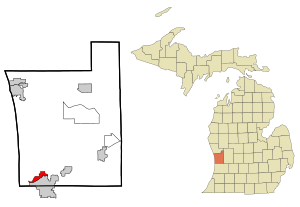
Beechwood, Michigan
Census-designated place & Unincorporated community in Michigan, United States
Distance: Approx. 2165 meters
Latitude and longitude: 42.79694444,-86.12583333
Beechwood is an unincorporated community in Ottawa County in the U.S. state of Michigan. It is a census-designated place (CDP) for statistical purposes, but is not an incorporated municipality. The population was 3,121 at the 2020 census.
Park Township, Ottawa County, Michigan
Township in Michigan, United States
Distance: Approx. 3444 meters
Latitude and longitude: 42.79833333,-86.17972222
Park Township is a civil township of Ottawa County in the U.S. state of Michigan. As of the 2020 census, the township population was 18,625.
WHTC
Radio station in Holland, Michigan
Distance: Approx. 3531 meters
Latitude and longitude: 42.79472222,-86.10611111
WHTC (1450 AM) is a news/talk radio station in Holland, Michigan.
West Ottawa High School
Distance: Approx. 2724 meters
Latitude and longitude: 42.8355,-86.1527
West Ottawa High School is located in Ottawa County, Michigan.

New Holland Brewing Company
American craft beer company
Distance: Approx. 1539 meters
Latitude and longitude: 42.804275,-86.12675
New Holland Brewing Company is an American independent craft brewing and distilling company headquartered in Holland, Michigan. It also owns and operates brewpub-style restaurants and spirits-tasting rooms located across West Michigan. The company's craft-style beer brands Dragon's Milk, Tangerine Space Machine, and spirits brands Dragon's Milk Origin, Beer Barrel Bourbon among others, are distributed throughout the United States and exported to Canada, Europe and Asia.

Macatawa River
River in Michigan, United States
Distance: Approx. 2964 meters
Latitude and longitude: 42.78891,-86.12476
The Macatawa River, also known as the Black River, is located in the lower part of Ottawa County, Michigan, which drains into Lake Macatawa and eventually into Lake Michigan. The main stream is 16.8 miles (27.0 km) long. Preluding the migration of Dutch settlers, the region was originally inhabited by three Anishinaabe nations: the Ottawa, Ojibwe, and Potawatomi.
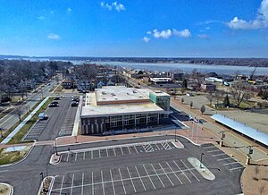
Holland Civic Center
Distance: Approx. 3381 meters
Latitude and longitude: 42.79,-86.114
The Holland Civic Center Place is a 2,000-seat multi-purpose event center located in Holland, Michigan, United States. It hosts local sporting events, recreation programming, public expos and concerts/live entertainment. The venue can also be rented for private events such as corporate luncheons, wedding receptions, expos/tradeshows, and many other uses.
Park Township Airport
Airport in Park Township, Michigan
Distance: Approx. 2447 meters
Latitude and longitude: 42.79583333,-86.16194444
Park Township Airport (IATA: HLM, ICAO: KHLM, FAA LID: HLM) was a public airport located in Park Township, 3 mi (5 km) northwest of Holland, Michigan, United States. Built in 1937, the airport was operated by Ottawa Aviation, an organization of local users whose aim was to promote the value of the airport to the surrounding community. The airport had a main paved runway (5/23) that was demolished around August 15, 2020, and an intersecting grass runway (12/30) that still exists today.

Holland Historic District (Holland, Michigan)
Historic district in Michigan, United States
Distance: Approx. 3696 meters
Latitude and longitude: 42.78666667,-86.11333333
The Holland Historic District is a primarily residential historic district in Holland, Michigan. It includes buildings along 11th, 12th, and 13th Streets from roughly Washington Boulevard on the west to College Avenue on the east, along with buildings on 14th Street from Pine Avenue on the west to just past College Avenue on the east, and buildings on 15th Street from Pine Avenue to River Avenue. The original portion of the district, on 11th, 12th, and 13th Streets between Washington Boulevard and Pine Avenue, was listed on the National Register of Historic Places in 1983.

Thomas and Anna Morrissey House
United States historic place
Distance: Approx. 3337 meters
Latitude and longitude: 42.78916667,-86.11611111
The Thomas and Anna Morrissey House was built as a private house, located at 190 West 9th Street in Holland, Michigan. It was listed on the National Register of Historic Places in 1999. It is one of the few houses in the area still standing that survived the disastrous 1871 forest fire that decimated Holland.

Isaac Cappon House
United States historic place
Distance: Approx. 3252 meters
Latitude and longitude: 42.78916667,-86.11777778
The Isaac Cappon House was constructed as a private house, located at 228 West 9th Street in Holland, Michigan. It was listed on the National Register of Historic Places in 1984. It is now operated as the Cappon House Museum.
Egbert H. Gold Estate
United States historic place
Distance: Approx. 3678 meters
Latitude and longitude: 42.78083333,-86.15583333
The Egbert H. Gold Estate, also known as the Marigold Lodge, is a summer estate located at 1116 Marigold Lane in Holland, Michigan. It was listed on the National Register of Historic Places in 1984. The estate is owned by furniture manufacturer Herman Miller, which uses it as a training center and private hotel for its customers.
Weather in this IP's area
clear sky
13 Celsius
12 Celsius
9 Celsius
14 Celsius
1020 hPa
60 %
1020 hPa
998 hPa
10000 meters
6.15 m/s
7.84 m/s
295 degree
6 %
07:17:26
20:07:04