Country:
 USA
USARegion:
City:
Latitude and Longitude:
Time Zone:
Postal Code:
IP information under different IP Channel
ip-api
Country
Region
City
ASN
Time Zone
ISP
Blacklist
Proxy
Latitude
Longitude
Postal
Route
IPinfo
Country
Region
City
ASN
Time Zone
ISP
Blacklist
Proxy
Latitude
Longitude
Postal
Route
MaxMind
Country
Region
City
ASN
Time Zone
ISP
Blacklist
Proxy
Latitude
Longitude
Postal
Route
Luminati
Country
USRegion
al
City
mobile
ASN
Time Zone
America/Chicago
ISP
UNITI-FIBER
Latitude
Longitude
Postal
db-ip
Country
Region
City
ASN
Time Zone
ISP
Blacklist
Proxy
Latitude
Longitude
Postal
Route
ipdata
Country
Region
City
ASN
Time Zone
ISP
Blacklist
Proxy
Latitude
Longitude
Postal
Route
Popular places and events near this IP address
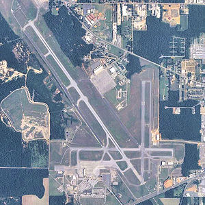
Mobile Regional Airport
Airport in Mobile County, Alabama, US
Distance: Approx. 4830 meters
Latitude and longitude: 30.69138889,-88.24277778
Mobile Regional Airport (IATA: MOB, ICAO: KMOB, FAA LID: MOB) is a public/military airport 13 miles (21 km) west of Mobile, in Mobile County, Alabama, United States. The airport is owned and operated by the Mobile Airport Authority, a self-funded entity that receives no local tax dollars. The National Plan of Integrated Airport Systems for 2011–2015 categorized it as a primary commercial service airport.

Mobile County Public School System
School district in Alabama
Distance: Approx. 7935 meters
Latitude and longitude: 30.72083333,-88.22361111
Mobile County Public School System (MCPSS) is a school district based in unincorporated Mobile County, Alabama, United States. The system currently serves areas of Mobile County, including the city of Mobile, with the exception of the cities of Saraland, Satsuma and Chickasaw. Saraland voted to separate its schools from Mobile County in 2006, with Satsuma and Chickasaw following suit in 2012.
Faith Academy (Mobile, Alabama)
Private coeducational secondary school in Mobile, Alabama, United States
Distance: Approx. 5140 meters
Latitude and longitude: 30.70293,-88.24493
Faith Academy is an independent, religious, co-educational private school in Mobile, Alabama, United States. The school was founded as Lott Road Christian Grade School in 1969, and was located in Eight Mile, Alabama for nineteen years until moving to its current location in 1988. The school changed its name during the 1971-1972 school year to reflect its emphasis on faith.
Big Creek Lake
Reservoir in Alabama, United States
Distance: Approx. 5888 meters
Latitude and longitude: 30.71222222,-88.34
Big Creek Lake (or Converse Reservoir) is a municipal reservoir which serves as the main source of drinking water for the city of Mobile, Alabama and its suburbs. It was formed by the damming of Big Creek, a tributary of the Escatawpa River in southwest Alabama. The reservoir was the subject of controversy in the 1980s over freshwater rights between Alabama and Mississippi.
Baker High School (Alabama)
Public school in Mobile, Alabama, United States
Distance: Approx. 3864 meters
Latitude and longitude: 30.6713,-88.25227
Baker High School is located in unincorporated Mobile County, Alabama, west of Mobile, and is a public high school operated by the Mobile County Public School System. The school educates students in grades 9-12. Baker High School is the largest high school in Mobile County with over 2,300 students enrolled and the second largest school in the state of Alabama.

USA Health Providence Hospital
Hospital in Alabama, United States
Distance: Approx. 8857 meters
Latitude and longitude: 30.67916667,-88.19888889
USA Health Providence Hospital (also known as Providence Hospital, formerly Ascension Providence) is a 349-bed high-rise hospital in the U.S. city of Mobile, Alabama. The hospital tower was completed in 1987. The building sits at the center of a 277-acre (112 ha) campus, it rises approximately 170 feet (52 m) and 11 stories.
Churchill Downs, Alabama
Unincorporated community in Alabama, United States
Distance: Approx. 9681 meters
Latitude and longitude: 30.76638889,-88.28194444
Churchill Downs is an unincorporated community in Mobile County, Alabama, in the United States.
National Weather Service Mobile, Alabama
Distance: Approx. 4919 meters
Latitude and longitude: 30.67942977,-88.24002268
National Weather Service-Mobile, Alabama, also known as National Weather Service-Mobile/Pensacola is a National Weather Service forecast office that is responsible for monitoring weather conditions for 20 counties in Alabama, Mississippi, and Florida, as well as 11 Marine Zones. The NWS Mobile office is located on the southeast side of Mobile Regional Airport. This area is part of the Southern Region Headquarters.
Hancock Whitney Stadium
Multi-purpose stadium in Alabama, U.S.A.
Distance: Approx. 9703 meters
Latitude and longitude: 30.696904,-88.192013
Hancock Whitney Stadium is a 25,450-seat multi-purpose stadium on the campus of the University of South Alabama in Mobile, Alabama. It is the home of the South Alabama Jaguars football program, starting with the 2020 season. The stadium replaced Ladd–Peebles Stadium, a city-owned all-purpose stadium located some 9 miles (14 km) from the campus where the school had played its football games since 2009.
Tanner Williams, Alabama
Unincorporated community in Alabama, United States
Distance: Approx. 9000 meters
Latitude and longitude: 30.72416667,-88.37
Tanner Williams is an unincorporated community in Mobile County, Alabama, United States.
Weather in this IP's area
scattered clouds
21 Celsius
22 Celsius
21 Celsius
22 Celsius
1019 hPa
95 %
1019 hPa
1012 hPa
10000 meters
3.09 m/s
60 degree
40 %
06:48:41
18:34:31