69.84.33.219 - IP Lookup: Free IP Address Lookup, Postal Code Lookup, IP Location Lookup, IP ASN, Public IP
Country:
Region:
City:
Location:
Time Zone:
Postal Code:
ISP:
ASN:
language:
User-Agent:
Proxy IP:
Blacklist:
IP information under different IP Channel
ip-api
Country
Region
City
ASN
Time Zone
ISP
Blacklist
Proxy
Latitude
Longitude
Postal
Route
db-ip
Country
Region
City
ASN
Time Zone
ISP
Blacklist
Proxy
Latitude
Longitude
Postal
Route
IPinfo
Country
Region
City
ASN
Time Zone
ISP
Blacklist
Proxy
Latitude
Longitude
Postal
Route
IP2Location
69.84.33.219Country
Region
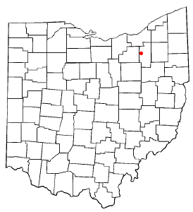
ohio
City
akron
Time Zone
America/New_York
ISP
Language
User-Agent
Latitude
Longitude
Postal
ipdata
Country
Region
City
ASN
Time Zone
ISP
Blacklist
Proxy
Latitude
Longitude
Postal
Route
Popular places and events near this IP address

Fairlawn, Ohio
City in Ohio, United States
Distance: Approx. 2310 meters
Latitude and longitude: 41.12666667,-81.62222222
Fairlawn is a city in western Summit County, Ohio, United States, and a suburb of Akron. The population was 7,710 at the 2020 census. It is part of the Akron metropolitan area.

Montrose-Ghent, Ohio
CDP in Ohio, United States
Distance: Approx. 3106 meters
Latitude and longitude: 41.15472222,-81.62638889
Montrose-Ghent is a census-designated place (CDP) in Summit County, Ohio, United States, composed of the unincorporated communities of Montrose and Ghent. The population was 5,254 at the 2020 census. It is part of the Akron Metropolitan Statistical Area.

Montrose, Ohio
Unincorporated community in Ohio, U.S.
Distance: Approx. 3282 meters
Latitude and longitude: 41.13555556,-81.63722222
Montrose is an unincorporated community on the border between Bath Township, Copley Township, and the city of Fairlawn in Summit County, Ohio, United States. It is an area of restaurants, stores, and businesses located along a stretch of State Route 18 near Interstate 77. The community is served by the Fairlawn (44333) post office.

Bath Township, Summit County, Ohio
Township in Ohio, United States
Distance: Approx. 3791 meters
Latitude and longitude: 41.15805556,-81.63333333
Bath Township is one of the nine townships of Summit County, Ohio, United States. A suburb of Akron, the 2020 census found 10,024 people in the township.

Ghent, Ohio
Unincorporated community in Ohio, United States
Distance: Approx. 4031 meters
Latitude and longitude: 41.15833333,-81.63666667
Ghent is an unincorporated community in central Bath Township, Summit County, Ohio, United States. It lies in the area of Granger and Cleveland-Massillon roads, just north of the Ghent Road exit of Interstate 77. It is included in the Montrose-Ghent census-designated place.
Downsize DC Foundation
American libertarian advocacy organization
Distance: Approx. 4158 meters
Latitude and longitude: 41.125,-81.551
The Downsize DC Foundation, formerly known as the American Liberty Foundation, is a policy advocacy organization which aims to limit the size of government in the United States through awareness and petitioning. Though it claims to be non-partisan, it does have strong political ties to the libertarian movement. It was founded by two-time Libertarian presidential candidate Harry Browne, his former campaign staff members Perry Willis and Jim Babka, and former National Chair of the Libertarian Party Steve Dasbach.

Botzum, Ohio
Hamlet in Ohio, United States
Distance: Approx. 3413 meters
Latitude and longitude: 41.16194444,-81.575
Botzum was a hamlet in Northampton Township, Summit County, Ohio around what is now the intersection of Bath and Riverview Roads in Akron and Cuyahoga Falls.
Firestone Community Learning Center
Public school in Akron, Ohio, United States
Distance: Approx. 3428 meters
Latitude and longitude: 41.11803,-81.565592
Firestone Community Learning Center (Firestone CLC), previously known as Harvey S. Firestone High School, is a public high school located on the northwest side of Akron, Ohio. It is one of seven high schools in the Akron Public Schools. The high school currently offers programs such as the Akron School for the Arts, International Baccalaureate Program, Project Lead The Way, Advanced Placement classes, and Firestone Theatre.
Summit Mall
Shopping mall in Ohio, United States
Distance: Approx. 1767 meters
Latitude and longitude: 41.13216,-81.6183
Summit Mall is a one-story, 850,000-square-foot (79,000 m2) enclosed shopping mall located at 3265 W. Market Street in the Akron suburb of Fairlawn., and with the closing of both Chapel Hill Mall and Rolling Acres Mall, is the only remaining mall in Summit County. Edward J. DeBartolo Sr.'s DeBartolo Corporation built the mall, which opened on October 28, 1965. Today, it is owned by Simon Property Group.
Cantors Assembly
Distance: Approx. 1505 meters
Latitude and longitude: 41.126087,-81.6092152
Cantors Assembly is the international association of hazzanim (cantors) affiliated with Conservative Judaism. It was founded in 1947 to develop the profession of the hazzan, to foster the fellowship and welfare of hazzanim, and to establish a conservatory for hazzanim. The latter goal was realized in 1952 with the establishment of the Cantors Institute at the Jewish Theological Seminary of America.
Sand Run (Cuyahoga River tributary)
Distance: Approx. 3192 meters
Latitude and longitude: 41.14,-81.56027778
Sand Run is a stream located entirely within Summit County, Ohio. It is a tributary of the Cuyahoga River. Sand Run was named for the sandstone outcroppings in the area.

Botzum station
Distance: Approx. 3182 meters
Latitude and longitude: 41.1595,-81.5752
Botzum is a Cuyahoga Valley Scenic Railroad train station in Cuyahoga Falls, Ohio, with a street address in Akron, Ohio. It is located adjacent to the Cuyahoga River and Riverview Road in the Cuyahoga Valley National Park. Initially a stop on the Valley Railway, trains began regular service at Botzum in 1880 — the station was a flag stop.
Weather in this IP's area
broken clouds
-15 Celsius
-22 Celsius
-15 Celsius
-15 Celsius
1026 hPa
83 %
1026 hPa
983 hPa
10000 meters
4.96 m/s
11.62 m/s
288 degree
54 %
