69.8.174.147 - IP Lookup: Free IP Address Lookup, Postal Code Lookup, IP Location Lookup, IP ASN, Public IP
Country:
Region:
City:
Location:
Time Zone:
Postal Code:
IP information under different IP Channel
ip-api
Country
Region
City
ASN
Time Zone
ISP
Blacklist
Proxy
Latitude
Longitude
Postal
Route
Luminati
Country
Region
tn
City
mcminnville
ASN
Time Zone
America/Chicago
ISP
BEN-LOMAND-TEL
Latitude
Longitude
Postal
IPinfo
Country
Region
City
ASN
Time Zone
ISP
Blacklist
Proxy
Latitude
Longitude
Postal
Route
IP2Location
69.8.174.147Country
Region
tennessee
City
crossville
Time Zone
America/Chicago
ISP
Language
User-Agent
Latitude
Longitude
Postal
db-ip
Country
Region
City
ASN
Time Zone
ISP
Blacklist
Proxy
Latitude
Longitude
Postal
Route
ipdata
Country
Region
City
ASN
Time Zone
ISP
Blacklist
Proxy
Latitude
Longitude
Postal
Route
Popular places and events near this IP address

Cumberland County, Tennessee
County in Tennessee, United States
Distance: Approx. 2427 meters
Latitude and longitude: 35.95,-85
Cumberland County is a county located in the U.S. state of Tennessee. As of the 2020 census, the population was 61,145. Its county seat is Crossville.

Crossville, Tennessee
City in Tennessee, United States
Distance: Approx. 703 meters
Latitude and longitude: 35.95416667,-85.03138889
Crossville is a city in and the county seat of Cumberland County, Tennessee, United States. It is part of the Crossville Micropolitan Statistical Area. The population was 12,071 at the 2020 census.
Little Obed River
River in Tennessee, United States
Distance: Approx. 5084 meters
Latitude and longitude: 35.9831236,-84.9894001
The Little Obed River is a ten mile long stream in the Cumberland Plateau in Cumberland County, Tennessee. The Little Obed rises east of Crossville and from near its source flows in a deep gorge that it has cut into the rocks capping the plateau, primarily sandstones of the Pennsylvanian Period. The depth of the gorge seems disproportionate to the size of the stream, as is typical of many of the streams of the plateau.

Cumberland Mountain State Park
State park in Tennessee, United States
Distance: Approx. 6024 meters
Latitude and longitude: 35.90056,-84.9971
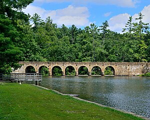
Cumberland Mountain State Park is a state park in Cumberland County, Tennessee, in the southeastern United States. The park consists of 1,720 acres (7.0 km2) situated around Byrd Lake, a man-made lake created by the impoundment of Byrd Creek in the 1930s. The park is set amidst an environmental microcosm of the Cumberland Plateau and provides numerous recreational activities, including an 18-hole Bear Trace golf course.
WAEW
Radio station in Crossville, Tennessee
Distance: Approx. 818 meters
Latitude and longitude: 35.95027778,-85.03583333
WAEW (1330 AM) is a radio station licensed to Crossville, Tennessee, United States. The station is owned by Peg Broadcasting.
WCSV
Radio station in Crossville, Tennessee
Distance: Approx. 818 meters
Latitude and longitude: 35.95027778,-85.03583333
WCSV (1490 AM, "97.7 The Ticket") is a radio station broadcasting a sports format. Licensed to Crossville, Tennessee, United States, the station is currently owned by Peg Broadcasting, LLC, and features programming from Fox Sports Radio.
Art Circle Public Library
Distance: Approx. 211 meters
Latitude and longitude: 35.94858,-85.02462
The Art Circle Public Library (ACPL) is located in Crossville, Cumberland County, Tennessee, and is part of the Falling Water Regional Library.

Palace Theater (Crossville, Tennessee)
United States historic place
Distance: Approx. 248 meters
Latitude and longitude: 35.94694444,-85.02583333
The Palace Theater at 210 N. Main St. in Crossville, Tennessee is a historic movie theater built in the 1930s.
Horace Burgess's Treehouse
Distance: Approx. 5008 meters
Latitude and longitude: 35.9855,-84.9944
Horace Burgess's Treehouse (also known as the Minister's Treehouse) was a treehouse and church in Crossville, Tennessee, United States. Construction began in 1993, mostly by Burgess, who says that, in a vision, God commanded him to build a treehouse. It became a popular local attraction and was unofficially called the largest tree house in the world.
Stone Memorial High School
Public high school in Tennessee, United States
Distance: Approx. 4273 meters
Latitude and longitude: 35.98412,-85.00777
Stone Memorial High School (SMHS) is one of two high schools in the Cumberland County School District and is in Crossville, Tennessee. According to U.S. News & World Report, "The AP® participation rate at Stone Memorial High School is 27 percent. The student body makeup is 53 percent male and 47 percent female, and the total minority enrollment is 6 percent." They have 1,053 students and 66 teachers.

Cumberland County Courthouse (Tennessee)
United States historic place
Distance: Approx. 105 meters
Latitude and longitude: 35.94805556,-85.02694444
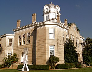
The Cumberland County Courthouse is a historic building in Crossville, Tennessee. It did serve as the courthouse Cumberland County until 2009 when a new justice center was built. It was built with sandstone from the county, and completed in 1905.
Upper Cumberland AVA
Viticultural area in Tennessee
Distance: Approx. 4810 meters
Latitude and longitude: 35.98888889,-85.00638889
Upper Cumberland is an American Viticultural Area (AVA) located in Tennessee and expands all or portions of the following eight counties in Middle Tennessee: Cumberland, Fentress, Macon, Putnam, Overton, Smith, Warren, and White. The viticultural area encircles the cities of Cookeville and McMinnville, lies east of Nashville and Murfreesboro, and encompasses approximately 3,417 square miles (2,186,689 acres) with 55 vineyards cultivating over 71 acres (29 ha) and sourcing nine wineries. There is at least one vineyard in each county within the AVA, demonstrating that commercial viticulture and wine-making occurs throughout the entire AVA with additional new vineyard and winery projects in various stages of development.
Weather in this IP's area
overcast clouds
-0 Celsius
-5 Celsius
-1 Celsius
-0 Celsius
1019 hPa
86 %
1019 hPa
951 hPa
10000 meters
4.63 m/s
12.86 m/s
300 degree
100 %