Country:
 South Africa
Region:
City:
Latitude and Longitude:
Time Zone:
Postal Code:
IP information under different IP Channel
ip-api
Country
Region
City
ASN
Time Zone
ISP
Blacklist
Proxy
Latitude
Longitude
Postal
Route
IPinfo
Country
Region
City
ASN
Time Zone
ISP
Blacklist
Proxy
Latitude
Longitude
Postal
Route
MaxMind
Country
Region
City
ASN
Time Zone
ISP
Blacklist
Proxy
Latitude
Longitude
Postal
Route
Luminati
Country
ZAASN
Time Zone
Africa/Johannesburg
ISP
CMCNETWORKS
Latitude
Longitude
Postal
db-ip
Country
Region
City
ASN
Time Zone
ISP
Blacklist
Proxy
Latitude
Longitude
Postal
Route
ipdata
Country
Region
City
ASN
Time Zone
ISP
Blacklist
Proxy
Latitude
Longitude
Postal
Route
Popular places and events near this IP address
Orlando, Soweto
Place in Gauteng, South Africa
Distance: Approx. 3560 meters
Latitude and longitude: -26.241,27.917
Orlando is a township in the urban area of Soweto, South Africa. The township was founded in 1931 and named after Edwin Orlando Leake, mayor of Johannesburg from 1925 to 1926. It is divided in two main areas: Orlando West and Orlando East.

Kliptown
Place in Gauteng, South Africa
Distance: Approx. 2102 meters
Latitude and longitude: -26.284,27.887
Kliptown is a suburb of the formerly black township of Soweto in Gauteng, South Africa, located about 17 km south-west of Johannesburg. Kliptown is the oldest residential district of Soweto, and was first laid out in 1891 on land which formed part of Klipspruit farm. The farm was named after the klipspruit (rocky stream) that runs nearby.
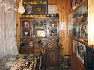
Congress of the People (1955)
Meeting of anti-apartheid activists and organisations in South Africa
Distance: Approx. 1379 meters
Latitude and longitude: -26.2775,27.88888889
The Congress of the People was a gathering organised by the National Action Council, a multi-racial organisation which later became known as the Congress Alliance, and held in Kliptown on 26 June 1955 to lay out the vision of the South African people. The Freedom Charter was drawn up at the gathering, which was statement of core principles of the Alliance and a symbol of internal resistance against apartheid.
Maponya Mall
Shopping centre in Soweto, South Africa.
Distance: Approx. 1090 meters
Latitude and longitude: -26.258715,27.902045
Maponya Mall is a shopping centre in Soweto, Pimville, South Africa. The 65,000 square-metre development cost R650m to build and officially opened in September 2007. The mall was owned by South African entrepreneur and property developer Richard Maponya until his death in early January 2020 under The Maponya group in partnership with Investec and ZenProp property holdings.
Mandela House
National Heritage Site of South Africa
Distance: Approx. 3411 meters
Latitude and longitude: -26.23853611,27.90877222
The Nelson Mandela National Museum, commonly referred to as Mandela House, is the house on Vilakazi Street, Orlando West, Soweto, South Africa, where Nelson Mandela lived from 1946 to 1962. It is located at number 8115, at the corner of Vilakazi and Ngakane streets, a short distance up the road from Tutu House, the home of Archbishop Emeritus Desmond Tutu. Mandela donated the house to the Soweto Heritage Trust (of which he was the founder) on 1 September 1997, to be run as a museum.
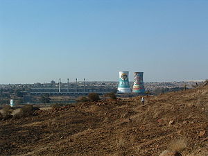
Orlando Power Station
Coal power station in South Africa (1942–1998)
Distance: Approx. 3212 meters
Latitude and longitude: -26.25388889,27.925
Orlando Power Station is a decommissioned coal-fired power station in Soweto, South Africa. The power station was commissioned at the end of the Second World War and served Johannesburg for over 50 years.

Tutu House
Home of Desmond and Leah Tutu in South Africa
Distance: Approx. 3388 meters
Latitude and longitude: -26.23928611,27.910175
The Tutu House is a house on Vilakazi Street in Soweto, Johannesburg, South Africa, that was the home to Desmond and Leah Tutu. The house is registered as part of Johannesburg's historical heritage.

Walter Sisulu Square
Monument in Kliptown, Soweto
Distance: Approx. 1379 meters
Latitude and longitude: -26.2775,27.88888889
Walter Sisulu Square, formally known as the Walter Sisulu Square of Dedication, is located in the heart of Kliptown in Soweto, South Africa. This location was the site where, on 26 June 1955, the Congress of the People, met to draw up the Freedom Charter, an alternative vision to the repressive policies of the apartheid state. The document emphasised a non-racial society, liberty and individual rights.
Soweto Cricket Oval
Multi-purpose stadium in Soweto, Gauteng, South Africa
Distance: Approx. 2908 meters
Latitude and longitude: -26.265,27.86736111
Soweto Cricket Oval is a multi-purpose stadium in Soweto, Gauteng. The ground is mainly used for organizing matches of cricket, although it has also been used occasionally for football and local events. The stadium hosted its only first-class match on October 27, 1995, where South Africa and England played to a draw.
Eldorado Park, Gauteng
Place in Gauteng, South Africa
Distance: Approx. 2438 meters
Latitude and longitude: -26.289,27.896
Eldorado Park is a suburb of Soweto, Johannesburg, South Africa. It is located in Region G of the City of Johannesburg Metropolitan Municipality. It lies on the southern boundary of Soweto and prior to 1994, was a Coloured township during Apartheid.
Killing of Nathaniel Julies
August 2020 police killing of a child with down syndrome in Eldorado Park, Johannesburg
Distance: Approx. 2823 meters
Latitude and longitude: -26.292426,27.89789
Nathaniel “Lockie” Julies, a 16 year-old boy with down syndrome, was fatally shot allegedly by South African Police Service (SAPS) officers Sergeant Simon ‘Scorpion’ Ndyalvane and Constable Caylene Whiteboy on the 26 August 2020. A third suspect, Detective Voster Netshiongolo, appeared before the Pretoria Magistrate’s Court. Julies was shot meters away from his home in the Eldorado Park area of Johannesburg, Gauteng.
Joburg Ladies Open
Golf tournament on the Sunshine Ladies Tour in Johannesburg, South Africa
Distance: Approx. 1284 meters
Latitude and longitude: -26.277,27.903
The Joburg Ladies Open is a women's professional golf tournament held in Johannesburg, South Africa. It is an event on the Southern Africa-based Sunshine Ladies Tour since 2015 and starting in 2022 co-sanctioned with the Ladies European Tour. It was played at the Royal Johannesburg & Kensington Golf Club until 2017.
Weather in this IP's area
overcast clouds
29 Celsius
28 Celsius
28 Celsius
30 Celsius
1007 hPa
24 %
1007 hPa
843 hPa
10000 meters
2.57 m/s
260 degree
86 %
05:30:08
18:16:34