Country:
 Canada
Region:
City:
Latitude and Longitude:
Time Zone:
Postal Code:
IP information under different IP Channel
ip-api
Country
Region
City
ASN
Time Zone
ISP
Blacklist
Proxy
Latitude
Longitude
Postal
Route
IPinfo
Country
Region
City
ASN
Time Zone
ISP
Blacklist
Proxy
Latitude
Longitude
Postal
Route
MaxMind
Country
Region
City
ASN
Time Zone
ISP
Blacklist
Proxy
Latitude
Longitude
Postal
Route
Luminati
Country
CAASN
Time Zone
America/Toronto
ISP
AS-IHS
Latitude
Longitude
Postal
db-ip
Country
Region
City
ASN
Time Zone
ISP
Blacklist
Proxy
Latitude
Longitude
Postal
Route
ipdata
Country
Region
City
ASN
Time Zone
ISP
Blacklist
Proxy
Latitude
Longitude
Postal
Route
Popular places and events near this IP address
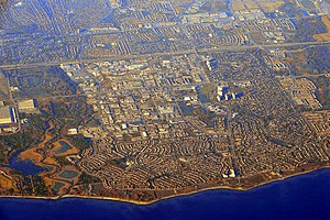
Ajax, Ontario
Town in Ontario, Canada
Distance: Approx. 1527 meters
Latitude and longitude: 43.85833333,-79.03638889
Ajax (; 2021 population: 126,666) is a waterfront town in Durham Region in Southern Ontario, Canada, located in the eastern part of the Greater Toronto Area. The town is named for HMS Ajax, a Royal Navy cruiser that served in the Second World War. It is approximately 11 kilometres (7 mi) east of Toronto on the shores of Lake Ontario and is bordered by the City of Pickering to the west and north, and the Town of Whitby to the east.

Ajax—Pickering
Former federal electoral district of Canada
Distance: Approx. 2778 meters
Latitude and longitude: 43.85055556,-79.055
Ajax—Pickering was a federal electoral district in Ontario, Canada, that had been represented in the House of Commons of Canada since 2011 by Conservative MP Chris Alexander. Its population in 2001 was 100,215. The district included the Town of Ajax and the northern part of the City of Pickering in the eastern suburbs of Toronto.

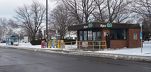
Ajax GO Station
Railway station in Ontario, Canada
Distance: Approx. 1720 meters
Latitude and longitude: 43.84777778,-79.04138889
Ajax GO Station is a train and bus station in the GO Transit network located in Ajax, Ontario, Canada. It is a stop on the Lakeshore East line and on the Oshawa/Finch Express bus route. The train platforms lie along the south side of Highway 401 with access to the station from Westney Road at Fairall Street.
Ajax High School
High school in Ajax, Ontario, Ontario, Canada
Distance: Approx. 889 meters
Latitude and longitude: 43.84444444,-79.01388889
Ajax High School (AHS) is located in Ajax, Ontario, Canada within the Durham District School Board. It is the largest secondary school in southern Ajax and the fourth-largest in all of Ajax. The school offers a wide range of academic and extracurricular activities.
Pickering Village
Neighbourhood in Durham, Ontario, Canada
Distance: Approx. 2470 meters
Latitude and longitude: 43.85222222,-79.05111111
Pickering Village is a former municipality and now a neighbourhood in the town of Ajax, within the Durham Region of Ontario, Canada. The Pickering Village derives its name from the former Pickering Township, which included the present-day town of Ajax and the city of Pickering. A small portion of the original settlement is now part of the Village East neighbourhood in the city of Pickering.
Ajax—Pickering (provincial electoral district)
Former provincial electoral district
Distance: Approx. 305 meters
Latitude and longitude: 43.85055556,-79.02416667
Ajax—Pickering was a provincial electoral district in central Ontario, Canada. It was first contested in the 2007 provincial election. 55.2% of the riding came from Pickering—Ajax—Uxbridge while 44.8% came from Whitby—Ajax.
Ajax Plaza Bus Terminal
Distance: Approx. 213 meters
Latitude and longitude: 43.84902778,-79.02097222
Ajax Plaza Bus Terminal was a bus station in Ajax, Ontario, Canada. It was located along the east side of the shopping centre parking lot at 190 Harwood Avenue South, south of Highway 401. The facility was used by Durham Region Transit, GO Transit and Greyhound.
Lakeridge Health Ajax and Pickering
Hospital in Ajax, Ontario, Canada
Distance: Approx. 1584 meters
Latitude and longitude: 43.8369,-79.0169
Lakeridge Health Ajax and Pickering is a hospital in Ajax, Ontario, Canada that is operated by Lakeridge Health. The hospital opened in 1954 as the Ajax and Pickering General Hospital. It was founded in 1954 as the Ajax and Pickering General Hospital with 38 patient beds.
Ajax Downs
Distance: Approx. 2634 meters
Latitude and longitude: 43.87089,-79.00285
Ajax Downs is a Quarter Horse race track located in Ajax, Ontario, a suburb east of Toronto, Ontario, Canada. Opened in 1969 as "Picov Downs" the name was changed in 2006 with the establishment of a new slot-machine gaming facility. The slots facility is known as Casino Ajax.

Pickering Casino Resort
Entertainment Complex in Ontario, Canada
Distance: Approx. 2997 meters
Latitude and longitude: 43.839309,-79.054092
The Pickering Casino Resort is a casino, resort, and entertainment venue that is currently under development in the Canadian city of Pickering, Ontario. During its planning, it was branded as Durham Live.

University of Toronto Ajax Division
Distance: Approx. 792 meters
Latitude and longitude: 43.844,-79.018
The Ajax Division was the University of Toronto's campus in Ajax, an unincorporated community (now a town) within the Pickering Township of Ontario, Canada. It was located at the site of the defunct Defence Industries Limited Pickering Works munitions plant, which was leased by the federal government to the university for a nominal rent. The Ajax Division was set up to meet the increasing demand for engineering education from World War II veterans returning from the war theatre in Europe.

Ajax Public Library
Public library system in Ajax, Canada
Distance: Approx. 68 meters
Latitude and longitude: 43.8514,-79.02088
Ajax Public Library is a public library system in Ajax, Ontario, Canada.
Weather in this IP's area
clear sky
16 Celsius
15 Celsius
15 Celsius
17 Celsius
1033 hPa
51 %
1033 hPa
1022 hPa
10000 meters
2.57 m/s
230 degree
07:34:38
18:27:17