Country:
 USA
USARegion:
City:
Latitude and Longitude:
Time Zone:
Postal Code:
IP information under different IP Channel
ip-api
Country
Region
City
ASN
Time Zone
ISP
Blacklist
Proxy
Latitude
Longitude
Postal
Route
IPinfo
Country
Region
City
ASN
Time Zone
ISP
Blacklist
Proxy
Latitude
Longitude
Postal
Route
MaxMind
Country
Region
City
ASN
Time Zone
ISP
Blacklist
Proxy
Latitude
Longitude
Postal
Route
Luminati
Country
USRegion
mi
City
canton
ASN
Time Zone
America/Detroit
ISP
123NET
Latitude
Longitude
Postal
db-ip
Country
Region
City
ASN
Time Zone
ISP
Blacklist
Proxy
Latitude
Longitude
Postal
Route
ipdata
Country
Region
City
ASN
Time Zone
ISP
Blacklist
Proxy
Latitude
Longitude
Postal
Route
Popular places and events near this IP address
Canton, Michigan
American township in Michigan
Distance: Approx. 2872 meters
Latitude and longitude: 42.30861111,-83.48222222
Canton Township (commonly known simply as Canton) is a charter township in Wayne County in the U.S. state of Michigan. A western suburb of Detroit, Canton is located roughly 23 miles (37.0 km) west of downtown Detroit, and 15 miles (24.1 km) east of Ann Arbor. As of the 2020 census, the township had a population of 98,659, making it Michigan's second most-populated township (after Clinton Township) and ninth most-populated municipality overall.
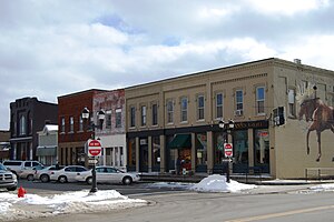
Plymouth, Michigan
City in Michigan, United States
Distance: Approx. 4481 meters
Latitude and longitude: 42.37138889,-83.47055556
Plymouth is a city in Wayne County in the U.S. state of Michigan. A western suburb of Detroit, Plymouth is located roughly 27 miles (43.5 km) northwest of downtown Detroit, and 18 miles (29.0 km) northeast of Ann Arbor. As of the 2020 census, the city had a population of 9,370.

Plymouth Charter Township, Michigan
Charter township in Michigan, United States
Distance: Approx. 4513 meters
Latitude and longitude: 42.37,-83.48194444
Plymouth Township is a charter township in Wayne County in the U.S. state of Michigan. A western suburb of Detroit, Plymouth Township is located roughly 27 miles (43.5 km) northwest of downtown Detroit, and 16 miles (25.7 km) northeast of Ann Arbor. As of the 2020 census, the township had a population of 27,938.
Plymouth-Canton Educational Park
Public secondary school in the United States
Distance: Approx. 2995 meters
Latitude and longitude: 42.34852,-83.49356
The Plymouth-Canton Educational Park (commonly PCEP or "The Park") encompasses three public secondary schools—Salem High School, Canton High School, and Plymouth High School—in Canton Township, Michigan, United States within Metro Detroit. PCEP is located on a 305-acre (123 ha) campus. PCEP is part of the Plymouth-Canton Community Schools District, serving portions of Wayne County and Washtenaw County, including City of Plymouth, Plymouth Township, and parts of Canton Township, Salem Township, Superior Township, and Northville Township.
WSDP
Radio station in Plymouth, Michigan
Distance: Approx. 3206 meters
Latitude and longitude: 42.3495,-83.4958
WSDP is the student-operated radio station owned by the Plymouth-Canton Educational Park in Canton, Michigan. The station positions itself as 88.1 The Park. WSDP is operated out of Salem High School and has been in operation since February 14, 1972.

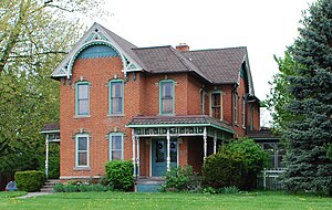
Charles G. Curtiss Sr. House
Historic house in Michigan, United States
Distance: Approx. 4525 meters
Latitude and longitude: 42.37194444,-83.46611111
The Charles G. Curtiss Sr. House is a private home at 168 S. Union St. in Plymouth, Michigan in the United States.

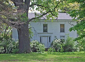
Phillip and Maria Hasselbach Dingledey House
Historic house in Michigan, United States
Distance: Approx. 2010 meters
Latitude and longitude: 42.31833333,-83.44861111
The Phillip and Maria Hasselbach Dingledey House was a private house located at 1638 Haggerty Road, near Westland in Canton Township, Michigan. It was listed on the National Register of Historic Places in 2000. The house is no longer at its listed location; a small commercial complex now occupies the site.
Ephraim and Emma Woodworth Truesdell House
Historic house in Michigan, United States
Distance: Approx. 3878 meters
Latitude and longitude: 42.29888889,-83.44833333
The Ephraim and Emma Woodworth Truesdell House is a private house located at 1224 Haggerty Road in Canton Township, Michigan. The structure is significant because it is one of the most finely crafted houses in the township and because of its association with one of the most important families in the area. It was listed on the National Register of Historic Places in 2003.
Benjamin and Mary Ann Bradford House
Historic house in Michigan, United States
Distance: Approx. 4089 meters
Latitude and longitude: 42.33527778,-83.515
The Benjamin and Mary Ann Bradford House is a private house located at 48145 Warren Road in Canton, Michigan. It was listed on the National Register of Historic Places in 2000.

Canton Township MPS
United States historic place
Distance: Approx. 3090 meters
Latitude and longitude: 42.30805556,-83.48611111
The Canton Township MPS is a multiple property submission, listed on the National Register of Historic Places in 2003. A multiple property submission is a group of related structures that share a common theme. The Canton Township MPS consists of eleven houses (some with associated property and outbuildings) built between 1825 and 1904 and located in Canton Township, Michigan.
Plymouth High School (Michigan)
Distance: Approx. 3236 meters
Latitude and longitude: 42.34681111,-83.49885556
Plymouth High School is a public high school in Canton Township, Michigan, United States. Plymouth High School is located on a campus of the Plymouth-Canton Educational Park in Wayne County.

United States Post Office Plymouth Station
United States historic place
Distance: Approx. 4506 meters
Latitude and longitude: 42.37166667,-83.46972222
The United States Post Office Plymouth Station is a former post office located at 860 Penniman Avenue in Plymouth, Michigan. It was listed on the National Register of Historic Places in 2024. The building houses Westborn Market.
Weather in this IP's area
clear sky
8 Celsius
6 Celsius
6 Celsius
9 Celsius
1020 hPa
89 %
1020 hPa
995 hPa
10000 meters
3.09 m/s
270 degree
07:07:06
19:56:00