Country:
 USA
USARegion:
City:
Latitude and Longitude:
Time Zone:
Postal Code:
IP information under different IP Channel
ip-api
Country
Region
City
ASN
Time Zone
ISP
Blacklist
Proxy
Latitude
Longitude
Postal
Route
IPinfo
Country
Region
City
ASN
Time Zone
ISP
Blacklist
Proxy
Latitude
Longitude
Postal
Route
MaxMind
Country
Region
City
ASN
Time Zone
ISP
Blacklist
Proxy
Latitude
Longitude
Postal
Route
Luminati
Country
USRegion
mi
City
pontiac
ASN
Time Zone
America/Detroit
ISP
123NET
Latitude
Longitude
Postal
db-ip
Country
Region
City
ASN
Time Zone
ISP
Blacklist
Proxy
Latitude
Longitude
Postal
Route
ipdata
Country
Region
City
ASN
Time Zone
ISP
Blacklist
Proxy
Latitude
Longitude
Postal
Route
Popular places and events near this IP address
Pontiac Central High School
Public high school, co-educational school
Distance: Approx. 782 meters
Latitude and longitude: 42.63802778,-83.30305556
Pontiac Central High School was one of two public high schools in Pontiac, Michigan, United States. It had been an accredited high school from September 4, 1849, until its closing on June 12, 2009. By December 2008 administrators had plans to consolidate it with Pontiac Northern High School to form Pontiac High School.

The Crofoot
Mixed-use independent entertainment complex
Distance: Approx. 1023 meters
Latitude and longitude: 42.6366,-83.2915
The Crofoot is a mixed-use independent entertainment complex made up of 3 venues in one building (The Crofoot Ballroom, The Pike Room, The Vernors Room) in Pontiac, Michigan. The Crofoot is a busy concert venue for popular music acts, and other larger private events or festivals. All-age shows as well as adult-only concerts are held.

Pontiac Transportation Center
Distance: Approx. 776 meters
Latitude and longitude: 42.6325,-83.29222222
The Pontiac Transportation Center is an intermodal terminal station located in Pontiac, Michigan that is served by Amtrak's Michigan Services Wolverine. The transportation center is also served by Indian Trails intercity bus service and Suburban Mobility Authority for Regional Transportation (SMART) regional bus service.
Sibley-Hoyt House
Building in West Lawrence Street, Pontiac Michigan
Distance: Approx. 718 meters
Latitude and longitude: 42.63688889,-83.29763889
The Sibley-Hoyt House is a historic house in Pontiac, Michigan that's center is a frame cabin dating to 1820 making it one of Pontiac's first structures. It was built by Solomon and Sarah Sibley, one of the founders of Pontiac. It is also the county's oldest house.
Crystal Lake (Pontiac, Michigan)
Lake in the state of Michigan, United States
Distance: Approx. 1105 meters
Latitude and longitude: 42.621332,-83.303911
Crystal Lake is a private 83-acre (34 ha) lake along the main branch of the Clinton River in Pontiac in Oakland County, Michigan. Upstream from Crystal Lake lies 532-acre (215 ha) Sylvan Lake. Downstream, the Clinton River goes underground in Pontiac near Orchard Lake Road and Bagley Avenue.

Myrick-Palmer House
Historic place in Michigan, United States
Distance: Approx. 620 meters
Latitude and longitude: 42.63666667,-83.30111111
The Myrick-Palmer House is a single-family house located at 223 W. Huron Street in Pontiac, Michigan. It was listed on the National Register of Historic Places in 1970.

Franklin Boulevard Historic District (Pontiac, Michigan)
United States historic place
Distance: Approx. 436 meters
Latitude and longitude: 42.635,-83.30194444
The Franklin Boulevard Historic District is a primarily residential historic district located in Pontiac, Michigan along Franklin Boulevard between West Huron Street and Orchard Lake Avenue. It also contains structures along Mary Day and Henry Clay Avenues between Franklin and Miller, and some structure along West Huron between Franklin and Williams, and along West Lawrence between Williams and the railroad. The district was listed on the National Register of Historic Places in 1983.
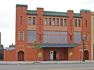
Eagle Theater (Pontiac, Michigan)
United States historic place
Distance: Approx. 1021 meters
Latitude and longitude: 42.63722222,-83.29222222
The Eagle Theater is a theater located at 11-15 South Saginaw Street in Pontiac, Michigan. It was listed on the National Register of Historic Places in 1984. It currently houses a nightclub.

Pontiac Commercial Historic District
United States historic place
Distance: Approx. 950 meters
Latitude and longitude: 42.63694444,-83.29305556
The Pontiac Commercial Historic District is a primarily commercial historic district located roughly along East Huron and South Saginaw Streets, within loop of Wide Track Drive, in Pontiac, Michigan. The core of the district, within the block bounded by Saginaw, Lawrence, Pike, and Wayne Streets, was originally listed on the National Register of Historic Places in 1984. A boundary increase creating the present boundaries was listed in 1989.

Grinnell Brothers Music House
United States historic place
Distance: Approx. 961 meters
Latitude and longitude: 42.63611111,-83.29194444
The Grinnell Brothers Music House is a commercial building located at 27 South Saginaw Street in Pontiac, Michigan. It was listed on the National Register of Historic Places in 1984.

Casa del Rey Apartments
United States historic place
Distance: Approx. 780 meters
Latitude and longitude: 42.6325,-83.31083333
The Casa del Rey Apartments is an apartment building located at 111 Oneida Road in Pontiac, Michigan. It was listed on the National Register of Historic Places in 1989.
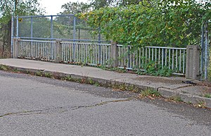
Gillespie Street-Clinton River Bridge
United States historic place
Distance: Approx. 634 meters
Latitude and longitude: 42.62611111,-83.29777778
The Gillespie Street-Clinton River Bridge is a bridge carrying Gillespie Street over the Clinton River in Pontiac, Michigan. It is a relatively early example of a rigid-frame bridge in Michigan. The bridge was listed on the National Register of Historic Places in 2000.
Weather in this IP's area
few clouds
8 Celsius
6 Celsius
6 Celsius
9 Celsius
1020 hPa
90 %
1020 hPa
986 hPa
10000 meters
2.57 m/s
250 degree
20 %
07:06:12
19:55:34