Country:
 USA
USARegion:
City:
Latitude and Longitude:
Time Zone:
Postal Code:
IP information under different IP Channel
ip-api
Country
Region
City
ASN
Time Zone
ISP
Blacklist
Proxy
Latitude
Longitude
Postal
Route
IPinfo
Country
Region
City
ASN
Time Zone
ISP
Blacklist
Proxy
Latitude
Longitude
Postal
Route
MaxMind
Country
Region
City
ASN
Time Zone
ISP
Blacklist
Proxy
Latitude
Longitude
Postal
Route
Luminati
Country
USRegion
mi
City
farmingtonhills
ASN
Time Zone
America/Detroit
ISP
123NET
Latitude
Longitude
Postal
db-ip
Country
Region
City
ASN
Time Zone
ISP
Blacklist
Proxy
Latitude
Longitude
Postal
Route
ipdata
Country
Region
City
ASN
Time Zone
ISP
Blacklist
Proxy
Latitude
Longitude
Postal
Route
Popular places and events near this IP address
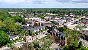
Farmington, Michigan
City in Michigan, United States
Distance: Approx. 658 meters
Latitude and longitude: 42.46444444,-83.37638889
Farmington is a city in Oakland County in the U.S. state of Michigan. A northwestern suburb of Detroit, Farmington is located roughly 20 miles (32.2 km) from downtown Detroit, and is surrounded on most sides by the larger city of Farmington Hills. As of the 2020 census, the city had a population of 11,594.

Farmington Hills, Michigan
City in Michigan, United States
Distance: Approx. 2374 meters
Latitude and longitude: 42.48527778,-83.37694444
Farmington Hills is a city in Oakland County in the U.S. state of Michigan. A northwestern suburb of Detroit, Farmington Hills is located roughly 22 miles (35.4 km) from downtown Detroit. As of the 2020 census, the city's population was 83,986, making it the second-largest community in Oakland County.
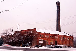
Farmington Winery (Michigan)
Winery
Distance: Approx. 1291 meters
Latitude and longitude: 42.45643,-83.35766
The Farmington Winery was the former LaSalle Winery which was operated in the converted Detroit United Railway Powerhouse in Farmington, Michigan. Production ceased in the late 1960s and the building was used primarily as a distribution center. Later, the St Julian Winery purchased the LaSalle brand.
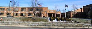
Farmington High School (Michigan)
Public high school in Farmington, Michigan, United States
Distance: Approx. 587 meters
Latitude and longitude: 42.46388889,-83.36138889
Farmington High School is a public high school located in Farmington, Michigan. The school was established in 1888, and the first sections of the current building were built in 1953, with several renovations and additions occurring since then. As of the 2022–2023 school year, the school educates a student body of 1,400.
Michigan School of Psychology
Private graduate school in Farmington Hills, Michigan, U.S.
Distance: Approx. 3051 meters
Latitude and longitude: 42.491482,-83.359344
The Michigan School of Psychology (MSP), formerly the Michigan School of Professional Psychology and the Center for Humanistic Studies, is a private graduate school in Farmington Hills, Michigan, which specializes in clinical psychology. It offers three programs of study: the Master of Arts (M.A.) in clinical psychology, which is offered in a one-year full-time or a two-year part-time format; the Doctor of Clinical Psychology (Psy.D.) degree, a full-time, minimum four-year, post-masters program; and a Certificate in Applied Behavior Analysis (ABA), a two-year certificate that can be completed concurrently with the MA program in clinical psychology.

Nardin Park United Methodist Church
Historic church in Michigan, United States
Distance: Approx. 3042 meters
Latitude and longitude: 42.4843,-83.3423
Nardin Park United Methodist Church is a Methodist church situated in Farmington Hills, Michigan. Nardin Park was first formed in 1927 by the union of two large churches in northwest Detroit - the Grand River Avenue Church, established in 1891, and the Ninde Church, organized in 1886. The name 'Nardin Park' was taken from the park and the subdivision where the church was located Nardin Park United Methodist Church was officially listed in Michigan's register of historic sites on September 21, 1990.
Farmington Central High School (Michigan)
Distance: Approx. 1836 meters
Latitude and longitude: 42.45805556,-83.34805556
Farmington Central High School is a public high school in Farmington, Michigan, which serves students ages 16–19 in an alternative setting while meeting the FPS benchmarks. The school is part of Farmington Public Schools. Central High is a consolidated version of Farmington Alternative High School and Farmington Community School.

Farmington Historic District (Farmington, Michigan)
Historic district in Michigan, United States
Distance: Approx. 796 meters
Latitude and longitude: 42.46555556,-83.37805556
Farmington Historic District is the town center of Farmington, Michigan. It was listed on the National Register of Historic Places in 1976. The area roughly corresponds to the section of Grand River Avenue and Shiawassee Avenue from Warner Street to junction of Grand River and Shiawassee.
Oakland Early College
Distance: Approx. 3087 meters
Latitude and longitude: 42.49261111,-83.36966667
Oakland Early College (OEC) is a five-year early college high school serving students throughout Oakland County, Michigan. It represents a partnership between the West Bloomfield School District and Oakland Community College's (OCC) Orchard Ridge campus. Newsweek's annual ranking of public schools in America ranked OEC as #159.

Royal Aldrich House
United States historic place
Distance: Approx. 2436 meters
Latitude and longitude: 42.485,-83.35666667
The Royal Aldrich House is a single-family house located at 31110 West 11 Mile Road in Farmington Hills, Michigan. It was listed on the National Register of Historic Places in 1994. It is one of a few remaining Greek Revival style houses in southeast Michigan still located on the site where built.
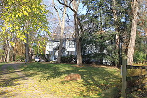
Botsford-Graser House
United States historic place
Distance: Approx. 1447 meters
Latitude and longitude: 42.47027778,-83.38444444
The Botsford-Graser House is a single-family home located at 24105 Locust Drive in Farmington Hills, Michigan. It was listed on the National Register of Historic Places in 2002. The house is significant in part as the home of Earle Graser, the voice of the Lone Ranger for some 13,000 performances on radio, and is also known as The Lone Ranger's House.

First United Methodist Church (Farmington, Michigan)
United States historic place
Distance: Approx. 436 meters
Latitude and longitude: 42.46416667,-83.37361111
The First United Methodist Church is a church located at 33112 Grand River Avenue in Farmington, Michigan. It was listed on the National Register of Historic Places in 2014.
Weather in this IP's area
clear sky
8 Celsius
7 Celsius
6 Celsius
9 Celsius
1020 hPa
90 %
1020 hPa
993 hPa
10000 meters
1.54 m/s
220 degree
07:06:36
19:55:43