69.36.203.170 - IP Lookup: Free IP Address Lookup, Postal Code Lookup, IP Location Lookup, IP ASN, Public IP
Country:
 USA
USARegion:
City:
Location:
Time Zone:
Postal Code:
ISP:
ASN:
language:
User-Agent:
Proxy IP:
Blacklist:
IP information under different IP Channel
ip-api
Country
Region
City
ASN
Time Zone
ISP
Blacklist
Proxy
Latitude
Longitude
Postal
Route
db-ip
Country
Region
City
ASN
Time Zone
ISP
Blacklist
Proxy
Latitude
Longitude
Postal
Route
IPinfo
Country
Region
City
ASN
Time Zone
ISP
Blacklist
Proxy
Latitude
Longitude
Postal
Route
IP2Location
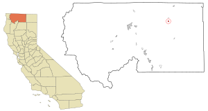
69.36.203.170Country
usRegion
california
City
macdoel
Time Zone
America/Los_Angeles
ISP
Language
User-Agent
Latitude
Longitude
Postal
ipdata
Country
Region
City
ASN
Time Zone
ISP
Blacklist
Proxy
Latitude
Longitude
Postal
Route
Popular places and events near this IP address

Macdoel, California
Census-designated place in California
Distance: Approx. 4 meters
Latitude and longitude: 41.82666667,-122.00527778
Macdoel is a census-designated place (CDP) in Siskiyou County, California, United States. Macdoel is located on U.S. Route 97 approximately halfway between Klamath Falls, Oregon and Weed. Its population is 86 as of the 2020 census, down from 133 from the 2010 census.
Mount Hebron, California
Census-designated place in California
Distance: Approx. 4487 meters
Latitude and longitude: 41.78638889,-122.005
Mount Hebron is a census-designated place in Siskiyou County, California, United States. Its population is 103 as of the 2020 census, up from 95 from the 2010 census.

Butte Valley National Grassland
Protected area in Siskiyou County, California
Distance: Approx. 8238 meters
Latitude and longitude: 41.899211,-122.025146
Butte Valley National Grassland is a 18,425-acre (7,456 ha) United States National Grassland located in northern California. Administered by the United States Forest Service, Klamath National Forest, it is located in northern Siskiyou County, near the Oregon border, between the communities of Dorris and Macdoel along U.S. Highway 97. It was dedicated in July 1991 as the nation's 20th National Grassland.

Meiss Lake
Lake in the state of California, United States
Distance: Approx. 5753 meters
Latitude and longitude: 41.860292,-122.05802
Meiss Lake is a 3,000-acre (12 km2), shallow, warm lake located in the western portion of Butte Valley, in eastern Siskiyou County. The lake is a remnant of a larger lake that occupied the entire valley when temperatures were cooler and is fed seasonally by several creeks in Butte Valley. Although Meiss Lake is in the closed Butte Creek Valley basin, in wetter times it undoubtedly flowed over a low divide into Rock Creek and then into the Klamath River east of Copco Lake.
Butte Valley Airport
Airport
Distance: Approx. 7174 meters
Latitude and longitude: 41.88722222,-121.97555556
Butte Valley Airport (FAA LID: A32, formerly CA03) is a county-owned public-use airport located five miles (8 km) southwest of the central business district of Dorris, in Siskiyou County, California, United States.
Hotel Macdoel
United States historic place
Distance: Approx. 298 meters
Latitude and longitude: 41.82861111,-122.00277778
Hotel Macdoel, at Montezuma Ave. and Mt. Shasta St.
Weather in this IP's area
overcast clouds
4 Celsius
1 Celsius
4 Celsius
4 Celsius
994 hPa
83 %
994 hPa
837 hPa
2.89 m/s
7.57 m/s
145 degree
100 %