69.27.184.91 - IP Lookup: Free IP Address Lookup, Postal Code Lookup, IP Location Lookup, IP ASN, Public IP
Country:
Region:
City:
Location:
Time Zone:
Postal Code:
IP information under different IP Channel
ip-api
Country
Region
City
ASN
Time Zone
ISP
Blacklist
Proxy
Latitude
Longitude
Postal
Route
Luminati
Country
Region
ca
City
halfmoonbay
ASN
Time Zone
America/Los_Angeles
ISP
CZIO-ASN
Latitude
Longitude
Postal
IPinfo
Country
Region
City
ASN
Time Zone
ISP
Blacklist
Proxy
Latitude
Longitude
Postal
Route
IP2Location
69.27.184.91Country
Region
california
City
half moon bay
Time Zone
America/Los_Angeles
ISP
Language
User-Agent
Latitude
Longitude
Postal
db-ip
Country
Region
City
ASN
Time Zone
ISP
Blacklist
Proxy
Latitude
Longitude
Postal
Route
ipdata
Country
Region
City
ASN
Time Zone
ISP
Blacklist
Proxy
Latitude
Longitude
Postal
Route
Popular places and events near this IP address
Filoli
Historic house in California, United States
Distance: Approx. 2080 meters
Latitude and longitude: 37.4704,-122.310703
Filoli, also known as the Bourn-Roth Estate, is a country house set in 16 acres (6.5 ha) of formal gardens surrounded by a 654-acre (265 ha) estate, located in Woodside, California, about 25 miles (40 km) south of San Francisco, at the southern end of Crystal Springs Reservoir, on the eastern slope of the Santa Cruz Mountains. Now owned by the National Trust for Historic Preservation, Filoli is open to the public. The site is both a California Historical Landmark and listed on the National Register of Historic Places.

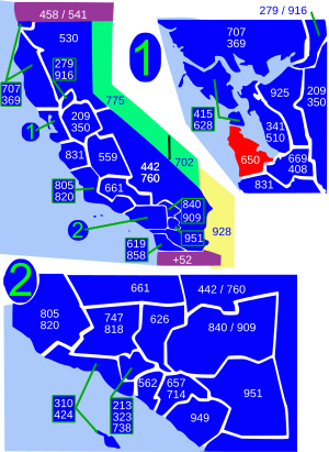
Area code 650
Area code for San Mateo County and parts of Santa Clara County, California
Distance: Approx. 3522 meters
Latitude and longitude: 37.5,-122.3
Area code 650 is a telephone area code in the North American Numbering Plan (NANP) for the San Francisco Bay Area in the U.S. state of California. It was split from area code 415 on August 2, 1997, and includes most of San Mateo County (except the northernmost portion), part of San Francisco, and the northwestern portion of Santa Clara County including Palo Alto, Mountain View, and Los Altos. Prior to October 2021, area code 650 had telephone numbers assigned for the central office code 988.

Pulgas Water Temple
California, USA structure
Distance: Approx. 1270 meters
Latitude and longitude: 37.483322,-122.317146
The Pulgas Water Temple is a stone structure in Redwood City, California, United States, designed by architect William G. Merchant. It was erected by the San Francisco Water Department to commemorate the 1934 completion of the Hetch Hetchy Aqueduct and is located at the aqueduct's terminus; originally water flowed through a vault under the temple itself, but new requirements for treatment require it to be diverted to a plant nearby. The name comes from Rancho de las Pulgas, an early Spanish land grant.
Adobe Gulch
Distance: Approx. 2481 meters
Latitude and longitude: 37.4979943,-122.347471
Adobe Gulch is a valley in San Mateo County, California, about 1.2 miles (1.9 km) long, located on the west side of Upper Crystal Springs Reservoir. It has an elevation of 97 meters, or 318 feet. It is located at 37-29'53 N and 122-20'51 W. Adobe Gulch is the northernmost of several tributaries (and the only one named by the USGS) that descend the eastern flank of the Santa Cruz Mountains to Upper Crystal Springs Reservoir (and historically, Laguna Creek).

San Francisco Bay AVA
Appelation that designates wine in San Francisco Bay Area, California, U.S.
Distance: Approx. 1814 meters
Latitude and longitude: 37.49052,-122.31521
San Francisco Bay is a multi-county American Viticultural Area (AVA) which is centered and surrounds the San Francisco Bay Area of Northern California. It was established on January 19, 1999 by the Bureau of Alcohol, Tobacco and Firearms (ATF), Treasury after evaluating the petition submitted by a consortium of nearly 75 growers and vintners led by Wente Bros. to establish the viticultural area known as "San Francisco Bay." It lies within the larger Central Coast viticultural area and includes San Francisco and counties encompassing the areas known as “South” and “East Bay.” This consists of Alameda, Contra Costa, Santa Clara, and San Mateo as well as portions of Santa Cruz and San Benito Counties.

Pulgas Ridge Open Space Preserve
Public recreation area in California, US
Distance: Approx. 3618 meters
Latitude and longitude: 37.47833333,-122.29
Pulgas Ridge Open Space Preserve is a public recreation area in the Santa Cruz Mountains, San Mateo County in northern California. It is managed by the Midpeninsula Regional Open Space District (MROSD). The nature reserve covers 366 acres (1.48 km2) with 6 miles (9.7 km) of trails with elevation changes of around 500 feet (150 m).

Phleger Estate
Park in San Mateo County, California, U.S.
Distance: Approx. 3890 meters
Latitude and longitude: 37.45,-122.30833333
The Phleger Estate is a park in San Mateo County, California, United States. The park is located outside the town of Woodside and adjacent to Huddart County Park. The park was acquired in 1991 by the Peninsula Open Space Trust (POST) for $25 million and is now part of the Golden Gate National Recreation Area (GGNRA).

San Mateo County Libraries
Distance: Approx. 3385 meters
Latitude and longitude: 37.5102159,-122.3352481
The San Mateo County Libraries (SMCL), formerly San Mateo County Library, is a public library system and Joint Powers Authority headquartered in San Mateo, California. Its motto is "Open for Exploration". It is a member of the Peninsula Library System.

Skylawn Memorial Park (San Mateo, California)
Cemetery in San Mateo County
Distance: Approx. 4032 meters
Latitude and longitude: 37.4971269,-122.3711267
Skylawn Memorial Park is a 505-acre (204 ha) cemetery, mausoleum, crematorium, columbarium and funeral home complex in San Mateo, California. Established in 1959, it is directly accessible from State Route 92. Interment records are at 1,308.

Laguna Creek (San Mateo County)
River in California, United States
Distance: Approx. 839 meters
Latitude and longitude: 37.4825,-122.32194444
Laguna Creek is a perennial stream that flows northwesterly for 2.6 miles (4.2 km) along the San Andreas Fault from Woodside in San Mateo County, California and, after crossing the Phleger Estate and Filoli, enters Upper Crystal Springs Reservoir, where it is a historic tributary to San Mateo Creek. San Mateo Creek then carries its waters over Crystal Springs Dam northeast to San Francisco Bay.
Hassler Health Farm
Tuberculosis Sanatorium, Public Hospital in San Carlos, California United States
Distance: Approx. 3757 meters
Latitude and longitude: 37.4764911,-122.2886004
Hassler Health Farm, formerly known as San Francisco Health Farm between 1927 and 1931, was a tuberculosis sanatorium for patients of the San Francisco Bay Area, owned by the City of San Francisco. It was located in a remote part of San Mateo County, California, in what is today San Carlos, until 1964. After the discovery of antibiotics, tuberculosis became a reduced threat, leading the building to be converted into a hospital for the poor.
Wakuriya
Japanese restaurant in San Mateo, California, U.S.
Distance: Approx. 4633 meters
Latitude and longitude: 37.521355,-122.336785
Wakuriya is a Japanese restaurant in San Mateo, California. The restaurant is owned by Katsuhiro and Mayumi Yamasaki. It has received a Michelin star award.
Weather in this IP's area
clear sky
9 Celsius
6 Celsius
6 Celsius
12 Celsius
1022 hPa
48 %
1022 hPa
1004 hPa
10000 meters
6.69 m/s
20 degree
