69.26.26.224 - IP Lookup: Free IP Address Lookup, Postal Code Lookup, IP Location Lookup, IP ASN, Public IP
Country:
Region:
City:
Location:
Time Zone:
Postal Code:
ISP:
ASN:
language:
User-Agent:
Proxy IP:
Blacklist:
IP information under different IP Channel
ip-api
Country
Region
City
ASN
Time Zone
ISP
Blacklist
Proxy
Latitude
Longitude
Postal
Route
db-ip
Country
Region
City
ASN
Time Zone
ISP
Blacklist
Proxy
Latitude
Longitude
Postal
Route
IPinfo
Country
Region
City
ASN
Time Zone
ISP
Blacklist
Proxy
Latitude
Longitude
Postal
Route
IP2Location
69.26.26.224Country
Region
north dakota
City
washburn
Time Zone
America/Chicago
ISP
Language
User-Agent
Latitude
Longitude
Postal
ipdata
Country
Region
City
ASN
Time Zone
ISP
Blacklist
Proxy
Latitude
Longitude
Postal
Route
Popular places and events near this IP address
Washburn, North Dakota
City in North Dakota, United States
Distance: Approx. 319 meters
Latitude and longitude: 47.29194444,-101.02777778
Washburn is a city in southern McLean County, North Dakota, United States. Located along the upper Missouri River, it is the county seat of McLean County. The population was 1,300 at the 2020 census.
Fort Mandan
American frontier fort used by Lewis & Clark
Distance: Approx. 4505 meters
Latitude and longitude: 47.29805556,-101.08722222
Fort Mandan was the name of the encampment which the Lewis and Clark Expedition built for wintering over in 1804–1805. The encampment was located on the Missouri River approximately twelve miles (19 km) from the site of present-day Washburn, North Dakota, which developed later. The precise location is not known for certain.

North Dakota Lewis and Clark Interpretive Center
Distance: Approx. 1635 meters
Latitude and longitude: 47.30111111,-101.04166667
The North Dakota Lewis and Clark Interpretive Center, operated by the North Dakota Parks and Recreation Department, interprets the history of the Lewis and Clark Expedition. It focuses on the winter of 1804–1805, which they spent at Fort Mandan, a post they built near a Mandan village. The center was opened in 1997 and overlooks the Missouri River on the outskirts of Washburn, North Dakota (38 miles north of Bismarck, North Dakota's capital), the center opened in 1997.

Cross Ranch State Park
Park in North Dakota, USA
Distance: Approx. 9308 meters
Latitude and longitude: 47.20722222,-101.00472222
Cross Ranch State Park is a public recreation area covering 569 acres (230 ha) on the west bank of the Missouri River nine miles (14 km) south of Washburn in Oliver County, North Dakota. The Nature Conservancy's Cross Ranch Nature Preserve, a 6,000-acre (2,400 ha) preserve which features a roaming herd of more than 200 adult bison, lies adjacent to the state park.

Hensler, North Dakota
Unincorporated community in North Dakota, United States
Distance: Approx. 5316 meters
Latitude and longitude: 47.26027778,-101.085
Hensler is an unincorporated rural village in Oliver County, North Dakota, United States, located along the BNSF railroad tracks near North Dakota Highway 200, 3.3 miles (5.3 km) southwest of Washburn. The village offers a county social services office and a grain elevator.

McLean County Courthouse (North Dakota)
United States historic place
Distance: Approx. 284 meters
Latitude and longitude: 47.29083333,-101.02611111
The McLean County Courthouse in Washburn, North Dakota was built in 1908. It was a 2+1⁄2-story brick building with a central tower above the front entrance. It was listed on the National Register of Historic Places in 1985.

Former McLean County Courthouse
United States historic place
Distance: Approx. 59 meters
Latitude and longitude: 47.28972222,-101.02888889
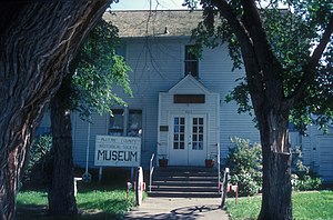
The Former McLean County Courthouse in Washburn, North Dakota was built in 1905 to replace a courthouse that had burned down, and was used as a courthouse until 1917, when the new McLean County Courthouse was built. The building is now used as one of the buildings of the McLean County Historical Society Museums. It was listed on the National Register of Historic Places in 1985.
Cross Ranch Archeological District
Historic district in North Dakota, United States
Distance: Approx. 8366 meters
Latitude and longitude: 47.21666667,-101
The Cross Ranch Archeological District near Hensler, North Dakota is a 6,365-acre (2,576 ha) historic district that was listed on the National Register of Historic Places (NRHP) in 1985. The listing included 149 contributing sites.
Weather in this IP's area
overcast clouds
-18 Celsius
-25 Celsius
-18 Celsius
-18 Celsius
1021 hPa
73 %
1021 hPa
947 hPa
10000 meters
6.47 m/s
13.74 m/s
190 degree
100 %

