Country:
 USA
USARegion:
City:
Latitude and Longitude:
Time Zone:
Postal Code:
IP information under different IP Channel
ip-api
Country
Region
City
ASN
Time Zone
ISP
Blacklist
Proxy
Latitude
Longitude
Postal
Route
IPinfo
Country
Region
City
ASN
Time Zone
ISP
Blacklist
Proxy
Latitude
Longitude
Postal
Route
MaxMind
Country
Region
City
ASN
Time Zone
ISP
Blacklist
Proxy
Latitude
Longitude
Postal
Route
Luminati
Country
USASN
Time Zone
America/Chicago
ISP
Latitude
Longitude
Postal
db-ip
Country
Region
City
ASN
Time Zone
ISP
Blacklist
Proxy
Latitude
Longitude
Postal
Route
ipdata
Country
Region
City
ASN
Time Zone
ISP
Blacklist
Proxy
Latitude
Longitude
Postal
Route
Popular places and events near this IP address
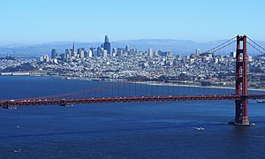
San Francisco
Consolidated city-county in California, US
Distance: Approx. 114 meters
Latitude and longitude: 37.7775,-122.41638889
San Francisco, officially the City and County of San Francisco, is the commercial, financial, and cultural center of Northern California. With a population of 808,437 residents as of 2022, San Francisco is the fourth most populous city in the U.S. state of California behind Los Angeles, San Diego, and San Jose. The city covers a land area of 46.9 square miles (121 square kilometers) at the upper end of the San Francisco Peninsula, making it the second-most densely populated major U.S. city behind New York City and the fifth-most densely populated U.S. county, behind four of New York City's boroughs.
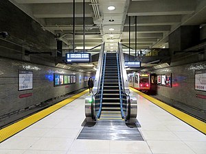
Van Ness station
Metro station in San Francisco, California
Distance: Approx. 250 meters
Latitude and longitude: 37.775,-122.419
Van Ness station is an underground Muni Metro station on the Market Street subway at the intersection of Market Street and Van Ness Avenue (U.S. Route 101) in San Francisco, California. The station consists of a concourse mezzanine on the first floor down, and a single island platform on the second level down.
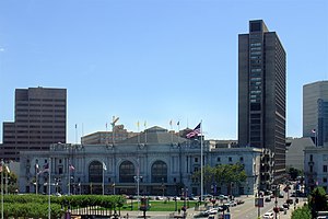
Bill Graham Civic Auditorium
A multi-purpose arena in San Francisco, California
Distance: Approx. 209 meters
Latitude and longitude: 37.778457,-122.417369
The Bill Graham Civic Auditorium (formerly San Francisco Civic Auditorium and San Francisco Exposition Auditorium) is a multi-purpose arena in San Francisco, California, named after promoter Bill Graham. The arena holds 8,500 people.
Fox Theatre (San Francisco)
Distance: Approx. 59 meters
Latitude and longitude: 37.77681,-122.41761
The Fox Theatre was a 4,651-seat movie palace located at 1350 Market Street in San Francisco, California. The theater was designed by the noted theater architect, Thomas W. Lamb. Opened in 1929, the theater operated until 1963, when it was closed and demolished.

100 Van Ness Avenue
Skyscraper in San Francisco, United States
Distance: Approx. 194 meters
Latitude and longitude: 37.77672222,-122.41919444
100 Van Ness is a skyscraper in San Francisco. Formerly an office building, it was converted into residential use. It is located in the Civic Center neighborhood near the San Francisco City Hall on Van Ness Avenue.

Fox Plaza (San Francisco)
Building in San Francisco, California, US
Distance: Approx. 63 meters
Latitude and longitude: 37.77714,-122.41723
Fox Plaza is a 29-story building located at 1390 Market Street in the Civic Center area of San Francisco. Built in 1966, the tower stands 354 ft (108 m) on the site of the former historic Fox Theatre at 1350 Market, which was opened in June 1929 and demolished in 1963. The first twelve floors contain office space.

NEMA (San Francisco)
Residential apartments in San Francisco, California
Distance: Approx. 89 meters
Latitude and longitude: 37.7759,-122.4175
NEMA, also known as Tenth and Market, is a 754-unit luxury residential apartment complex in the Mid-Market neighborhood of San Francisco, California, United States, across the street from Twitter's corporate headquarters. The complex consists of a 24-story, tower at Jessie and Tenth Streets and a 37-story, tower at Market and Tenth Streets, connected by a nine-story podium along Tenth Street.
Caldron (sex club)
Gay sex club in San Francisco, California
Distance: Approx. 236 meters
Latitude and longitude: 37.7744852,-122.4171509
The Caldron (often misspelled Cauldron) was a sex club for gay men located at 953 Natoma Street in San Francisco's South of Market neighborhood. It opened in 1980 and closed in 1984.

Market and 9th Street / Market and Larkin stations
Distance: Approx. 113 meters
Latitude and longitude: 37.777456,-122.416306
Market and 9th Street (eastbound) and Market and Larkin (westbound) are a pair of one-way light rail stations in San Francisco, California, United States, serving the San Francisco Municipal Railway F Market & Wharves heritage railway line. They are located on Market Street at the intersections of 9th Street and Larkin Street. The low-level platforms are also utilized by several bus and trolleybus routes.
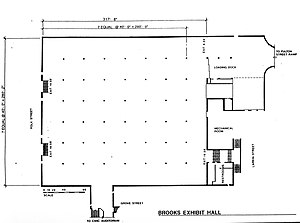
Brooks Hall
Disused event venue in San Francisco, California
Distance: Approx. 265 meters
Latitude and longitude: 37.778951,-122.417502
Brooks Hall (originally Civic Center Exhibit Hall, nicknamed Mole Hall and Gopher Palace) is a disused 90,000 sq ft (8,400 m2) event space underneath the southern half of Civic Center Plaza in San Francisco; a parking garage occupies the space under the northern half. It was built in the late 1950s for $4,500,000, and dedicated on April 11, 1958. It was named after Thomas A. Brooks, a chief administrative officer of the City and County of San Francisco, who retired the same year the building was dedicated.

Hotel Whitcomb
Historic hotel in San Francisco
Distance: Approx. 243 meters
Latitude and longitude: 37.7781,-122.415
The Hotel Whitcomb is a San Francisco hotel that was built from 1911 to 1912. Located at 1231 Market Street, the Whitcomb opened in 1912 as San Francisco's temporary city hall and then reopened in 1917 as a 400-room hotel.
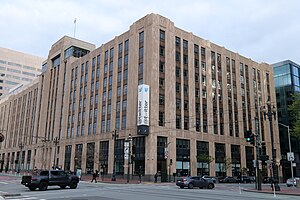
Market Square (San Francisco)
Building in San Francisco, California
Distance: Approx. 24 meters
Latitude and longitude: 37.77638889,-122.41694444
Market Square (formerly the Western Furniture Exchange and Merchandise Mart, the San Francisco Mart, and, colloquially, the Twitter Building) is an Art Deco building in the Mid-Market neighborhood of San Francisco, California, United States. Located at 1355 Market Street, it was constructed in 1937 and originally served as a showroom for retailers and wholesalers in the furniture industry. In the early 21st century, the building underwent an extensive conversion into office and retail space, and is most well known as the former headquarters of Twitter, Inc.
Weather in this IP's area
few clouds
18 Celsius
18 Celsius
15 Celsius
25 Celsius
1011 hPa
78 %
1011 hPa
1009 hPa
10000 meters
10.29 m/s
14.4 m/s
300 degree
20 %
06:45:26
19:29:54