69.19.196.80 - IP Lookup: Free IP Address Lookup, Postal Code Lookup, IP Location Lookup, IP ASN, Public IP
Country:
Region:
City:
Location:
Time Zone:
Postal Code:
IP information under different IP Channel
ip-api
Country
Region
City
ASN
Time Zone
ISP
Blacklist
Proxy
Latitude
Longitude
Postal
Route
Luminati
Country
ASN
Time Zone
America/Chicago
ISP
US-TELEPACIFIC
Latitude
Longitude
Postal
IPinfo
Country
Region
City
ASN
Time Zone
ISP
Blacklist
Proxy
Latitude
Longitude
Postal
Route
IP2Location
69.19.196.80Country
Region
texas
City
houston
Time Zone
America/Chicago
ISP
Language
User-Agent
Latitude
Longitude
Postal
db-ip
Country
Region
City
ASN
Time Zone
ISP
Blacklist
Proxy
Latitude
Longitude
Postal
Route
ipdata
Country
Region
City
ASN
Time Zone
ISP
Blacklist
Proxy
Latitude
Longitude
Postal
Route
Popular places and events near this IP address
Westbury, Houston
Neighborhood in Houston, Texas, United States
Distance: Approx. 776 meters
Latitude and longitude: 29.6506,-95.4897
Westbury is a neighborhood in the Brays Oaks district of Southwest Houston, Texas, United States. It is located east of Bob White Road, north of U.S. Highway 90 Alternate (South Main Street), and west of South Post Oak Road, adjacent to the Fondren Southwest and Meyerland neighborhoods, just west of the southwest corner of the 610 Loop. Westbury was named as the 2007 "Best Hidden Neighborhood" by the Houston Press [4].

Texas's 9th congressional district
U.S. House district for Texas
Distance: Approx. 1355 meters
Latitude and longitude: 29.64555556,-95.49416667
Texas's 9th congressional district of the United States House of Representatives includes the southwestern portion of the Greater Houston area in Texas. The current Representative for the district, since 2005, is Democrat Al Green. From 1967 to 2005, the 9th covered an area stretching from Galveston through Houston to Beaumont.
Westbury High School (Houston)
High school in Brays Oaks, Texas
Distance: Approx. 164 meters
Latitude and longitude: 29.64972222,-95.48111111
Westbury High School is a secondary school located in the Brays Oaks, of Southwest Houston, Texas, near the Westbury neighborhood. It has grades 9 through 12, and is part of the Houston Independent School District. In 2019, Jerri Nixon succeeded Susan Monaghan as principal, who had retired.
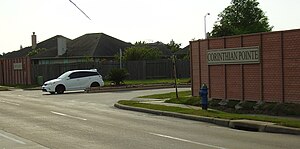
Corinthian Pointe, Houston
Planned community in Houston, Texas, US
Distance: Approx. 2464 meters
Latitude and longitude: 29.63,-95.474
Corinthian Pointe is a large planned affordable subdivision located in Houston, Texas, in the United States. It is a part of the larger master planned community Pointe 2.3.4, and is within the 5 Corners District. Corinthian Pointe is located immediately outside the 610 Loop and inside Beltway 8 near Reliant Park.

Robert M. Beren Academy
Distance: Approx. 2873 meters
Latitude and longitude: 29.6541,-95.4522
Robert M. Beren Academy is a private Modern Orthodox Jewish primary and secondary school at 11333 Cliffwood Drive in Houston, Texas, United States. Robert M. Beren Academy is located near the Willow Meadows and Willowbend neighborhoods. The school covers preschool through grade 12 and includes an elementary Montessori program.

Westbury Christian School
School
Distance: Approx. 2267 meters
Latitude and longitude: 29.6676456,-95.495369
Westbury Christian School is a private, co-educational, K3 through 12th grade Christian school located in Houston, Texas, United States. Westbury Christian School is open to students of all faiths, nationalities, and ethnic origins.
Torah Day School of Houston
Distance: Approx. 2896 meters
Latitude and longitude: 29.661378,-95.509202
Torah Day School of Houston is a Jewish Day School in Houston established in 1977 by the Texas Regional Headquarters of the Chabad Lubavitch. It offers a Jewish education to grades K-8 in addition to its Early Childhood Center for children ages eighteen months through four years old.
Leader's Academy High School for Business and Academic Success
Charter school
Distance: Approx. 2562 meters
Latitude and longitude: 29.628288,-95.478183
Leader's Academy High School for Business and Academic Success, previously the High School for Business and Economic Success (HSBES), was a Grade 7–12 state charter school located on the campus of Windsor Village United Methodist Church in Windsor Village, Houston, in the U.S. state of Texas. The school was formerly named Gulf Shores Academy. In 2011 it merged with Benji's Special Educational Academy into Victory Preparatory Academy.

Brays Oaks, Houston
Area in Southwest Houston, Texas, United States
Distance: Approx. 2029 meters
Latitude and longitude: 29.66,-95.5
Brays Oaks, formerly known as Fondren Southwest, is an area in Southwest Houston, Texas, United States. The Brays Oaks Management District, also known as the Harris County Improvement District #5, governs the Brays Oaks area as well as other surrounding areas, such as Westbury. The City of Houston also defines the Brays Oaks Super Neighborhood, with separate boundaries.

Imani School
Distance: Approx. 1930 meters
Latitude and longitude: 29.645633,-95.462773
The Imani School is a Christian private elementary and middle school in The Community Collective, a multi-purpose complex in the 5 Corners District, and in Southwest Houston, Texas, United States. The school is marketed to African-American children.

The Varnett Public School
Public charter school in Houston, Texas
Distance: Approx. 1606 meters
Latitude and longitude: 29.656423,-95.466271
The Varnett Public School is a state charter school network headquartered in the Varnett School Southwest Campus in Houston, Texas. The system has four campuses with more than 1,600 students. The school was founded as a private school in 1984 and became a public charter school in 1998.
Westbury Square
Past Texas shopping centre
Distance: Approx. 712 meters
Latitude and longitude: 29.657227,-95.479584
Westbury Square was a shopping center located on a 7.5-acre (3.0 ha) site near the intersection of Chimney Rock Road and West Bellfort Avenue, in the Westbury neighborhood in the Brays Oaks district of Southwest Houston, Texas. It was built as a part of Westbury Section 3.
Weather in this IP's area
thunderstorm
17 Celsius
16 Celsius
15 Celsius
19 Celsius
1015 hPa
84 %
1015 hPa
1013 hPa
10000 meters
10.29 m/s
15.43 m/s
330 degree
100 %


