69.176.28.3 - IP Lookup: Free IP Address Lookup, Postal Code Lookup, IP Location Lookup, IP ASN, Public IP
Country:
 USA
USARegion:
City:
Location:
Time Zone:
Postal Code:
ISP:
ASN:
language:
User-Agent:
Proxy IP:
Blacklist:
IP information under different IP Channel
ip-api
Country
Region
City
ASN
Time Zone
ISP
Blacklist
Proxy
Latitude
Longitude
Postal
Route
db-ip
Country
Region
City
ASN
Time Zone
ISP
Blacklist
Proxy
Latitude
Longitude
Postal
Route
IPinfo
Country
Region
City
ASN
Time Zone
ISP
Blacklist
Proxy
Latitude
Longitude
Postal
Route
IP2Location
69.176.28.3Country
usRegion
kentucky
City
martin
Time Zone
America/New_York
ISP
Language
User-Agent
Latitude
Longitude
Postal
ipdata
Country
Region
City
ASN
Time Zone
ISP
Blacklist
Proxy
Latitude
Longitude
Postal
Route
Popular places and events near this IP address
Floyd County, Kentucky
County in Kentucky, United States
Distance: Approx. 1201 meters
Latitude and longitude: 37.56,-82.75
Floyd County is a county located in the U.S. state of Kentucky. As of the 2020 census, the population was 35,942. Its county seat is Prestonsburg.

Allen, Kentucky
City in Kentucky, United States
Distance: Approx. 5410 meters
Latitude and longitude: 37.60944444,-82.72777778
Allen, also known as Allen City, is a home rule-class city in Floyd County, Kentucky, in the United States. The population was 193 at the 2010 census, up from 150 at the 2000 census.
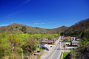
Martin, Kentucky
City in Kentucky, United States
Distance: Approx. 805 meters
Latitude and longitude: 37.57277778,-82.75277778
Martin is a home rule-class city in Floyd County, Kentucky, in the United States. The population was 634 as of the 2010 census.

Dwale, Kentucky
Census-designated place in Kentucky, United States
Distance: Approx. 6550 meters
Latitude and longitude: 37.62083333,-82.72722222
Dwale is an unincorporated community and census-designated place in Floyd County, Kentucky, United States. The 2010 United States Census reported that Dwale's population was 329, of which 312 persons were white and 9 persons were Asian. The origins of the name Dwale are unclear.
Pyramid, Kentucky
Unincorporated community in Kentucky, United States
Distance: Approx. 2690 meters
Latitude and longitude: 37.56472222,-82.72916667
Pyramid is an unincorporated community located in Floyd County, Kentucky, United States.
Warco, Kentucky
Unincorporated community in Kentucky, United States
Distance: Approx. 3004 meters
Latitude and longitude: 37.54416667,-82.77583333
Warco is an unincorporated community in Floyd County, Kentucky, United States.
Alphoretta, Kentucky
Unincorporated community in Kentucky, United States
Distance: Approx. 691 meters
Latitude and longitude: 37.56305556,-82.76444444
Alphoretta is an unincorporated community and coal town in Floyd County, Kentucky, United States.
Printer, Kentucky
Unincorporated community in Kentucky, United States
Distance: Approx. 4392 meters
Latitude and longitude: 37.52972222,-82.74638889
Printer is an unincorporated community and coal town in Floyd County, Kentucky, United States. The community has the name of John Printer Meade, a pioneer citizen.
Banner, Kentucky
Unincorporated community in Kentucky, United States
Distance: Approx. 6195 meters
Latitude and longitude: 37.59916667,-82.70138889
Banner is an unincorporated community in Floyd County, Kentucky, United States. It was also known as Mouth of Prater.
Dana, Kentucky
Unincorporated community in Kentucky, United States
Distance: Approx. 6214 meters
Latitude and longitude: 37.55416667,-82.69111111
Dana is an unincorporated community in Floyd County, Kentucky, United States.
Langley, Kentucky
Unincorporated community in Kentucky, United States
Distance: Approx. 4886 meters
Latitude and longitude: 37.53166667,-82.79083333
Langley is an unincorporated community in Floyd County, Kentucky, United States. It corresponds to the Maytown census-designated place.
Beaver Creek (Kentucky)
Stream in Floyd County, Kentucky, U.S.
Distance: Approx. 5763 meters
Latitude and longitude: 37.613987,-82.7298805
Beaver Creek is a stream in Floyd County, Kentucky, in the United States. It is located between the towns of Martin and Allen City. Some of the first white visitors to Floyd County camped on Beaver Creek in 1775.
Weather in this IP's area
overcast clouds
2 Celsius
-1 Celsius
1 Celsius
4 Celsius
1028 hPa
86 %
1028 hPa
987 hPa
10000 meters
3.09 m/s
250 degree
100 %