69.170.224.15 - IP Lookup: Free IP Address Lookup, Postal Code Lookup, IP Location Lookup, IP ASN, Public IP
Country:
 USA
USARegion:
City:
Location:
Time Zone:
Postal Code:
ISP:
ASN:
language:
User-Agent:
Proxy IP:
Blacklist:
IP information under different IP Channel
ip-api
Country
Region
City
ASN
Time Zone
ISP
Blacklist
Proxy
Latitude
Longitude
Postal
Route
db-ip
Country
Region
City
ASN
Time Zone
ISP
Blacklist
Proxy
Latitude
Longitude
Postal
Route
IPinfo
Country
Region
City
ASN
Time Zone
ISP
Blacklist
Proxy
Latitude
Longitude
Postal
Route
IP2Location
69.170.224.15Country
usRegion
oklahoma
City
ada
Time Zone
America/Chicago
ISP
Language
User-Agent
Latitude
Longitude
Postal
ipdata
Country
Region
City
ASN
Time Zone
ISP
Blacklist
Proxy
Latitude
Longitude
Postal
Route
Popular places and events near this IP address
Pontotoc County, Oklahoma
County in Oklahoma, United States
Distance: Approx. 5849 meters
Latitude and longitude: 34.72,-96.69
Pontotoc County is a county in the south central part of Oklahoma. As of the 2020 census, the population was 38,065. Its county seat is Ada.
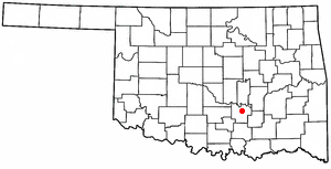
Ada, Oklahoma
City in Oklahoma, United States
Distance: Approx. 1411 meters
Latitude and longitude: 34.76361111,-96.66833333
Ada is a city in and the county seat of Pontotoc County, Oklahoma, United States. The population was 16,481 at the 2020 United States Census. The city was named for Ada Reed, the daughter of an early settler, and was incorporated in 1901.

East Central University
Public university in Ada, Oklahoma, US
Distance: Approx. 1425 meters
Latitude and longitude: 34.77444444,-96.66472222
East Central University (ECU or East Central) is a public university in Ada, Oklahoma. It is part of Oklahoma's Regional University System. Beyond its flagship campus in Ada, the university has courses available in McAlester, Shawnee, and Durant, as well as online courses.

Sugg Clinic
Building in Oklahoma, United States
Distance: Approx. 181 meters
Latitude and longitude: 34.77222222,-96.67805556
The Sugg Clinic is considered an outstanding example of the Streamline Moderne architectural style. The building, which is listed in the National Register of Historic Places, is located at 100 E 13th Street in Ada, Oklahoma. Opened in 1947, it was called "one of the best equipped clinics in the Southwest." Architect Albert S. Ross designed it to fulfill Dr.
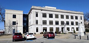
Pontotoc County Courthouse
United States historic place
Distance: Approx. 90 meters
Latitude and longitude: 34.7726,-96.6795
The Pontotoc County Courthouse is a historic courthouse in Ada, Oklahoma. The building has been listed on the National Register of Historic Places since 1984. The county built the structure in 1926.

Ada Arts and Heritage Center
United States historic place
Distance: Approx. 336 meters
Latitude and longitude: 34.77105278,-96.67647222
The Ada Arts and Heritage Center is a Colonial Revival styled building located at 400 South Rennie Street in Ada, Oklahoma. The building was listed on the National Register of Historic Places as Ada Public Library in 1989. The building was built in 1939 to serve as the public library of Ada.

Wintersmith Park Historic District
Historic district in Oklahoma, United States
Distance: Approx. 2739 meters
Latitude and longitude: 34.75944444,-96.65416667
The Wintersmith Park Historic District, known locally as simply Wintersmith Park, is a historic district located at 18th Street and Scenic Drive in Ada, Oklahoma. The park includes a lake, a lodge, bridges, trails, courts and a public amphitheater. The area is listed in the National Register of Historic Places.

Ada Gaming Center
Distance: Approx. 3244 meters
Latitude and longitude: 34.78944444,-96.65166667
The Ada Gaming Center is a Native American casino in Ada, Oklahoma. The center is the first gaming facility that was founded by the Chickasaw Nation, having started out as a bingo hall in 1983. The 22,482 sq ft (2,088.6 m2) facility includes a bar, the Traditions Bar, and a restaurant, the Double Down Grill, and 9,220 sq ft (857 m2) of gaming space.

McSwain Theatre
Distance: Approx. 565 meters
Latitude and longitude: 34.776975,-96.68005278
The McSwain Theatre is a 560-seat former cinema, and present day theater and music venue, located in Ada, Pontotoc County, Oklahoma. The theatre was founded in 1920 by Foster McSwain, as a venue for silent films and vaudeville performances, and after 1935 for talkies movies and local movie premieres.
Latta, Oklahoma
Unincorporated community in Oklahoma, United States
Distance: Approx. 3713 meters
Latitude and longitude: 34.74694444,-96.70694444
Latta is an unincorporated community and census-designated place in Pontotoc County, Oklahoma, United States. Its population was 1,172 as of 2016. Oklahoma State Highway 1 passes through the community.
Latta High School (Oklahoma)
Public high school in Ada, Oklahoma
Distance: Approx. 3206 meters
Latitude and longitude: 34.7524,-96.7058
Latta High School is a high school located in Latta, Oklahoma, with an Ada postal address. It is the only high school in the Latta School District, which includes Latta and portions of Ada. 39% of the student body is economically disadvantaged.
F.W. Meaders House
United States historic place
Distance: Approx. 292 meters
Latitude and longitude: 34.76944444,-96.67888889
The F.W. Meaders House, at 521 South Broadway in Ada, Oklahoma, was built in 1929. It was listed on the National Register of Historic Places in 2007. It was designed by local architect Albert S. Ross.
Weather in this IP's area
mist
5 Celsius
3 Celsius
5 Celsius
5 Celsius
1021 hPa
100 %
1021 hPa
985 hPa
1609 meters
2.57 m/s
20 degree
100 %