Country:
 USA
USARegion:
City:
Latitude and Longitude:
Time Zone:
Postal Code:
IP information under different IP Channel
ip-api
Country
Region
City
ASN
Time Zone
ISP
Blacklist
Proxy
Latitude
Longitude
Postal
Route
IPinfo
Country
Region
City
ASN
Time Zone
ISP
Blacklist
Proxy
Latitude
Longitude
Postal
Route
MaxMind
Country
Region
City
ASN
Time Zone
ISP
Blacklist
Proxy
Latitude
Longitude
Postal
Route
Luminati
Country
USRegion
ca
City
sebastopol
ASN
Time Zone
America/Los_Angeles
ISP
AS-SONICTELECOM
Latitude
Longitude
Postal
db-ip
Country
Region
City
ASN
Time Zone
ISP
Blacklist
Proxy
Latitude
Longitude
Postal
Route
ipdata
Country
Region
City
ASN
Time Zone
ISP
Blacklist
Proxy
Latitude
Longitude
Postal
Route
Popular places and events near this IP address

Sebastopol, California
City in California, United States
Distance: Approx. 1898 meters
Latitude and longitude: 38.39916667,-122.82694444
Sebastopol ( sib-AST-ə-pohl, -pool) is a city in Sonoma County, in California with a recorded population of 7,521, per the 2020 U.S. Census. Sebastopol was once primarily a plum- and apple-growing region. Today, wine grapes are the predominant agriculture crop, and nearly all lands once used for orchards are now vineyards.
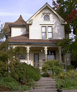
George A. Strout House
Historic house in California, United States
Distance: Approx. 1691 meters
Latitude and longitude: 38.40263889,-122.82916667
The George A. Strout House is a registered historic place in Sebastopol, California. The house received a Preservation Award from the Western Sonoma County Historical Society in 1977. It was placed on the National Register of Historic Places in 1980.

Luther Burbank's Gold Ridge Experiment Farm
United States historic place
Distance: Approx. 1317 meters
Latitude and longitude: 38.39666667,-122.83472222
Luther Burbank's Gold Ridge Experiment Farm is the official name of the 3 acres (12,000 m2) that remain of the farm originally purchased in 1885 by famed plant breeder Luther Burbank (1849-1926) in an area of Sebastopol, California, formerly known as the "Gold Ridge District". To these 10 acres (40,000 m2), Burbank added 5 acres (20,000 m2) in 1904 and 3.046 acres (12,330 m2) in 1906 until, in 1923, failing health compelled him to sell 3.046 acres (12,330 m2) of his holdings. Burbank died in 1926.
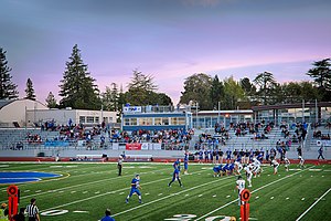
Analy High School
Public school
Distance: Approx. 2106 meters
Latitude and longitude: 38.40725,-122.8255
Analy High School (formerly West County High School) is a public high school in Sebastopol, Sonoma County, California. It was established in 1908 as Analy High School. In 2021 Analy merged with El Molino High School and was known under the working name West County High School for one year, before returning to its original name.
Graton Rancheria
Former native Indian settlements in Southern California
Distance: Approx. 3442 meters
Latitude and longitude: 38.41647778,-122.883025
The Graton Rancheria was a 15.45-acre (62,500 m2) property in the coastal hills of northern California, about two miles (3 km) northwest of Sebastopol. The site is about 1.5 miles (2.4 km) southwest of the hamlet of Graton, population 1,815 in 2000. The area is a few miles west of Santa Rosa, the largest of Sonoma County's nine cities and the County seat, population 147,595 in 2000.

Ragle Ranch Regional Park
Distance: Approx. 470 meters
Latitude and longitude: 38.4052,-122.8511
Ragle Ranch Regional Park is a regional park in Sebastopol, California, U.S.A. that is maintained by the Sonoma County Regional Parks Department. It covers an area of 157 acres (64 ha) on the west side of town. The park entrance is at 500 Ragle Road, and the day use fee is $7 per vehicle.
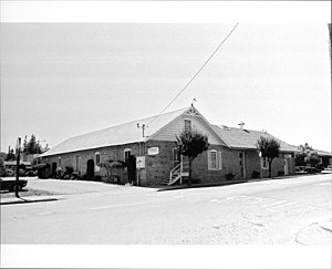
Petaluma and Santa Rosa Railway Powerhouse
Building in California, United States
Distance: Approx. 2247 meters
Latitude and longitude: 38.40129,-122.82275
The Petaluma and Santa Rosa Railway Power House is a historic building in Sebastopol, California, U.S., built to serve the Petaluma and Santa Rosa Railroad, an electric interurban railway of Sonoma County. It is also known as the Hogan Building and the P&SR Substation. It was listed on the National Register of Historic Places in 1991.
Rancho Cañada de Jonive
Mexican land grant in California
Distance: Approx. 3032 meters
Latitude and longitude: 38.39,-122.88
Rancho Cañada de Jonive was a 10,787-acre (43.65 km2) Mexican land grant in present day Sonoma County, California given in 1845 by Governor Pío Pico to James Black. The grant encompassed the town of Freestone.
Freeman Vineyard & Winery
Distance: Approx. 3033 meters
Latitude and longitude: 38.4096,-122.8817
Freeman Vineyard & Winery is a California winery based in the Southern Russian River Valley AVA just outside Sebastopol in Sonoma County. The winery was founded in 2001 by Ken and Akiko Freeman. They are recognized for producing cool-climate Pinot noir and Chardonnay in a Burgundian style.

Sebastopol station (Petaluma and Santa Rosa Railroad)
United States historic place
Distance: Approx. 2318 meters
Latitude and longitude: 38.400833,-122.821944
Sebastopol station was an interurban train station in Sebastopol, California. It was served by the Petaluma and Santa Rosa Railroad and was adjacent to the railway's powerhouse. Official operations ceased in 1932 with the rest of P&SR passenger service.
Merry Edwards Winery
Californian winery
Distance: Approx. 3764 meters
Latitude and longitude: 38.434914,-122.855073
Merry Edwards is a Californian winery, established in 1997. It is noted for its Pinot noirs in the Russian River Valley AVA of Sonoma County.

Hinds Hotel
United States historic place
Distance: Approx. 4229 meters
Latitude and longitude: 38.43722222,-122.865
The Hinds Hotel (also known as the Freestone House, Freestone Hotel, Park House, and Wayside Inn) is a historic building located in Freestone, California in the United States. Built in 1876, the Hinds Hotel is a former hotel, antique store and plant nursery. Today, it serves as a private commercial business and home.
Weather in this IP's area
clear sky
23 Celsius
23 Celsius
20 Celsius
27 Celsius
1011 hPa
58 %
1011 hPa
1006 hPa
10000 meters
4.63 m/s
170 degree
06:57:01
19:13:00