69.1.99.77 - IP Lookup: Free IP Address Lookup, Postal Code Lookup, IP Location Lookup, IP ASN, Public IP
Country:
 USA
USARegion:
City:
Location:
Time Zone:
Postal Code:
ISP:
ASN:
language:
User-Agent:
Proxy IP:
Blacklist:
IP information under different IP Channel
ip-api
Country
Region
City
ASN
Time Zone
ISP
Blacklist
Proxy
Latitude
Longitude
Postal
Route
db-ip
Country
Region
City
ASN
Time Zone
ISP
Blacklist
Proxy
Latitude
Longitude
Postal
Route
IPinfo
Country
Region
City
ASN
Time Zone
ISP
Blacklist
Proxy
Latitude
Longitude
Postal
Route
IP2Location
69.1.99.77Country
usRegion
oregon
City
albany
Time Zone
America/Los_Angeles
ISP
Language
User-Agent
Latitude
Longitude
Postal
ipdata
Country
Region
City
ASN
Time Zone
ISP
Blacklist
Proxy
Latitude
Longitude
Postal
Route
Popular places and events near this IP address
Linn County, Oregon
County in Oregon, United States
Distance: Approx. 1933 meters
Latitude and longitude: 44.63,-123.09
Linn County is one of the 36 counties in the U.S. state of Oregon. As of the 2023 census population estimates, the population was 131,496. The county seat is Albany.

Albany, Oregon
City in Oregon, United States
Distance: Approx. 2454 meters
Latitude and longitude: 44.63027778,-123.09666667
Albany ( AL-bə-nee) is the county seat of Linn County, Oregon, and is the 11th most populous city in the state. Albany is located in the Willamette Valley at the confluence of the Calapooia River and the Willamette River in both Linn and Benton counties, just east of Corvallis and south of Salem. It is predominantly a farming and manufacturing city that settlers founded around 1848.

Albany Parks & Recreation
Distance: Approx. 3379 meters
Latitude and longitude: 44.63525278,-123.10684444
The Albany Parks & Recreation is a city agency in Albany, Oregon, United States responsible for maintaining the local city parks as well as organizing cultural events. Its headquarters are at City Hall, 333 Broadalbin Street SW. One goal of the City of Albany is to have all residents live within 2 miles (3 km) of a park.

Albany Municipal Airport (Oregon)
Airport
Distance: Approx. 1463 meters
Latitude and longitude: 44.63777778,-123.05944444
Albany Municipal Airport (FAA LID: S12) is a general aviation airport located 3 nautical miles (6 km) east of the city of Albany in Linn County, Oregon, United States. It is publicly owned and operated by the City of Albany. It is the oldest known operating airfield in Oregon, having opened in 1920.

Albany station (Oregon)
Distance: Approx. 2907 meters
Latitude and longitude: 44.63027778,-123.1025
Albany station is an Amtrak intercity rail station in Albany, Oregon, United States. It is served by the Amtrak Cascades and the Coast Starlight passenger trains, and is the westernmost Amtrak station. Albany station also serves as the hub for local transit.

South Albany High School
Public school in Albany, , Oregon, United States
Distance: Approx. 2179 meters
Latitude and longitude: 44.607777,-123.077778
South Albany High School (SAHS) is a public high school located in Albany, Oregon, United States. Built in 1970, South Albany occupies the largest facility in the Greater Albany Public School District, encompassing more than 167,000 square feet (15,500 m2) of classrooms and other facilities with its outdoor campus.
Albany Options School
Public school in Albany, , Oregon, United States
Distance: Approx. 2205 meters
Latitude and longitude: 44.622888,-123.093964
Albany Options School is a public alternative school in Albany, Oregon, United States. It provides alternative education for students who are working below or above state benchmark standards in a community-based setting that is put in place to support students who may struggle in a more traditional high school environment. These opportunities include transitional programs, credit-recovery programs, higher-education courses and education through contracted services.

Hackleman Historic District
Historic district in Oregon, United States
Distance: Approx. 2808 meters
Latitude and longitude: 44.63472222,-123.09944444
The Hackleman Historic District in Albany Oregon, was placed on the list of National Register of Historic Places (NRHP) in 1982. The district contains 228 historic properties within about a 28 city blocks area. The district was named after Abner Hackleman who came to Albany in 1845.

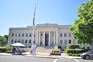
Linn County Courthouse (Oregon)
Distance: Approx. 3354 meters
Latitude and longitude: 44.63447,-123.10686
The Linn County Courthouse is located at 300 SW 4th Avenue in Albany, Oregon, United States. In 1851, the Oregon Territorial Legislature passed an act establishing Albany as the county seat. The original county courthouse was erected in Albany in 1853 but was destroyed by fire in 1861.

Methodist Episcopal Church South (Albany, Oregon)
Historic church in Oregon, United States
Distance: Approx. 3056 meters
Latitude and longitude: 44.63588889,-123.10216667
Methodist Episcopal Church South (Bethesda Heritage Church) is a historic church at 238 E. 3rd Street in Albany, Oregon. It was built circa 1875 and added to the National Register in 1979.

Heritage Mall
Shopping mall in Oregon, United States
Distance: Approx. 1236 meters
Latitude and longitude: 44.6305,-123.0804
Heritage Mall is a shopping center in Albany, Oregon, United States. Anchored by Hobby Lobby, Ross Dress For Less, and Target, the 406,500-square-foot (37,770 m2) mall opened in 1988. Located near the junction of Interstate 5 and U.S. Route 20, the mall sits on 33 acres (13 ha) and is the largest in the Albany-Corvallis-Lebanon metropolitan area.

George Earle Chamberlain House (Albany, Oregon)
Historic house in Oregon, United States
Distance: Approx. 2948 meters
Latitude and longitude: 44.632656,-123.102271
The George Earle Chamberlain House is a historic house in Albany, Oregon, United States. Governor George Earle Chamberlain's house was entered on the National Register of Historic Places in 1980.
Weather in this IP's area
overcast clouds
1 Celsius
-1 Celsius
-1 Celsius
2 Celsius
1012 hPa
82 %
1012 hPa
1001 hPa
1.54 m/s
4.1 m/s
172 degree
100 %