68.70.249.178 - IP Lookup: Free IP Address Lookup, Postal Code Lookup, IP Location Lookup, IP ASN, Public IP
Country:
Region:
City:
Location:
Time Zone:
Postal Code:
ISP:
ASN:
language:
User-Agent:
Proxy IP:
Blacklist:
IP information under different IP Channel
ip-api
Country
Region
City
ASN
Time Zone
ISP
Blacklist
Proxy
Latitude
Longitude
Postal
Route
db-ip
Country
Region
City
ASN
Time Zone
ISP
Blacklist
Proxy
Latitude
Longitude
Postal
Route
IPinfo
Country
Region
City
ASN
Time Zone
ISP
Blacklist
Proxy
Latitude
Longitude
Postal
Route
IP2Location
68.70.249.178Country
Region
georgia
City
alpharetta
Time Zone
America/New_York
ISP
Language
User-Agent
Latitude
Longitude
Postal
ipdata
Country
Region
City
ASN
Time Zone
ISP
Blacklist
Proxy
Latitude
Longitude
Postal
Route
Popular places and events near this IP address

Johns Creek (Chattahoochee River tributary)
River in Georgia, United States
Distance: Approx. 3287 meters
Latitude and longitude: 34.00472222,-84.22388889
Johns Creek is an 8.0-mile-long (12.9 km) stream which begins in southern Forsyth County, Georgia and runs south-southwestward through the eastern part of northern Fulton County, Georgia (formerly the separate Milton County). It is a tributary of the Chattahoochee River and has no official stream gauges. The name of Johns Creek, Georgia, incorporated in late 2006, is taken from this creek that runs through the center of the new city.

Ocee, Georgia
Distance: Approx. 4736 meters
Latitude and longitude: 34.0645434,-84.2126972
Ocee was a small community in Milton County, now located in Johns Creek in Fulton County, Georgia. It was centered at 34°03′52″N 84°12′46″W. It was originally called New York, then Mazeppa. The Ocee name, which was taken from the name of a Cherokee community in the area, is still in use today for a school, a park, a library and a church, among others.

Chattahoochee High School
School in Johns Creek, Georgia, United States
Distance: Approx. 3785 meters
Latitude and longitude: 34.04799,-84.20776
Chattahoochee High School (colloquially referred to as "Hooch") is a public high school in Johns Creek, Georgia, United States, within the Fulton County School System. It is located next to its only feeder school, Taylor Road Middle School. It has been recognized by the U.S. Department of Education as one of America's Blue Ribbon Schools.
Johns Creek, Georgia
City in Georgia, United States
Distance: Approx. 3684 meters
Latitude and longitude: 34.03333333,-84.20277778
Johns Creek is a city in Fulton County, Georgia, United States. According to the 2020 census, the population was 82,453. The city is a northeastern suburb of Atlanta.
North Point Community Church
US evangelical church in Alpharetta, Georgia
Distance: Approx. 3463 meters
Latitude and longitude: 34.057565,-84.259669
North Point Community Church is a non-denominational, evangelical megachurch located in Alpharetta, Georgia, a suburb of Atlanta. North Point has an attendance of 23,000 people in eight locations in the north metro Atlanta area. The senior pastor Andy Stanley serves as the church's lead pastor and, in turn, leads the North Point Community Church staff.
Johns Creek High School
Public high school in Johns Creek, Georgia, United States
Distance: Approx. 4298 meters
Latitude and longitude: 34.022684,-84.196739
Johns Creek High School is a public high school in Johns Creek, Georgia, United States, serving grades 9–12. The school is a part of the Fulton County School System. Its students primarily reside inside the city of Johns Creek, though the school also serves part of Alpharetta.
Autrey Mill Nature Preserve & Heritage Center
Nature center in Johns Creek, Georgia, USA
Distance: Approx. 1360 meters
Latitude and longitude: 34.02079,-84.23267
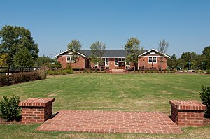
The Autrey Mill Nature Preserve & Heritage Center is located in Johns Creek, Georgia, United States. The Autrey Mill Nature Preserve & Heritage Center provides a venue where visitors can learn about the past as well as appreciate nature. The property is located on 9770 Autrey Mill Road, Johns Creek, Georgia.

Dean Gardens
Prominent house in USA
Distance: Approx. 3932 meters
Latitude and longitude: 34.00614167,-84.21096389
Dean Gardens was one of the largest homes in metropolitan Atlanta, Georgia. At the time of its completion in 1992, the 32,000 square foot, 15 bedroom house was the largest in Atlanta. The former owner, Larry Dean, who made his fortune in software, spent $30 million on its construction, plus $1.5 million a year on its upkeep.

RiverPines Golf
Distance: Approx. 2812 meters
Latitude and longitude: 34.010164,-84.223476
RiverPines Golf is a public golf facility located in Johns Creek, Georgia north of Atlanta, Georgia.
Mount Pisgah Christian School
Private Christian school in Johns Creek, Georgia, United States
Distance: Approx. 3287 meters
Latitude and longitude: 34.01888889,-84.27555556
Mount Pisgah Christian School is a private Christian school located in Johns Creek, Georgia, United States. It is located on Nesbit Ferry Road off of Highway 19. The school is accredited by the Southern Association of Colleges and Schools (SACS) and the Southern Association of Independent Schools (SAIS) including memberships with the National Association of Independent Schools (NAIS), the Georgia High School Association (GHSA) and the Atlanta Christian School Association (ACSA).
Chess Club and Scholastic Center of Atlanta
Distance: Approx. 4106 meters
Latitude and longitude: 34.021668,-84.28588
The Chess Club and Scholastic Center of Atlanta (CCSCATL) is a chess venue located in Roswell, Georgia. It is administered by co-founder Tom Poyer Saunders, a chess grandmaster from Malvern, England.

Newtown Elementary School
United States historic place
Distance: Approx. 2648 meters
Latitude and longitude: 34.02055556,-84.26888889
Newtown Elementary School, in what is now Johns Creek, Georgia, was built in 1929. It was listed on the National Register of Historic Places in August 2006.
Weather in this IP's area
broken clouds
7 Celsius
7 Celsius
6 Celsius
9 Celsius
1030 hPa
32 %
1030 hPa
991 hPa
10000 meters
1.04 m/s
1.07 m/s
256 degree
83 %

