Country:
 USA
USARegion:
City:
Latitude and Longitude:
Time Zone:
Postal Code:
IP information under different IP Channel
ip-api
Country
Region
City
ASN
Time Zone
ISP
Blacklist
Proxy
Latitude
Longitude
Postal
Route
IPinfo
Country
Region
City
ASN
Time Zone
ISP
Blacklist
Proxy
Latitude
Longitude
Postal
Route
MaxMind
Country
Region
City
ASN
Time Zone
ISP
Blacklist
Proxy
Latitude
Longitude
Postal
Route
Luminati
Country
USASN
Time Zone
America/Chicago
ISP
KEYDEV
Latitude
Longitude
Postal
db-ip
Country
Region
City
ASN
Time Zone
ISP
Blacklist
Proxy
Latitude
Longitude
Postal
Route
ipdata
Country
Region
City
ASN
Time Zone
ISP
Blacklist
Proxy
Latitude
Longitude
Postal
Route
Popular places and events near this IP address

Crystal City, Virginia
Neighborhood in Arlington, Virginia, United States
Distance: Approx. 490 meters
Latitude and longitude: 38.85140278,-77.05068889
Crystal City is an urban neighborhood in the southeastern corner of Arlington County, Virginia, approximately 5 miles south of Downtown Washington, D.C. Due to its extensive integration of office buildings and residential high-rise buildings using underground corridors, travel between stores, offices, and residences, it is possible to travel much of the neighborhood without going above ground, making at least part of Crystal City an underground city. Crystal City includes several aerospace manufacturing and defense industry companies, public sector consulting firms, government contractors, the U.S. Department of Labor, the U.S. Marshals Service, satellite offices for the Pentagon, and various nonprofit organizations, including the International Foundation for Electoral Systems and the national headquarters for PBS. Ronald Reagan Washington National Airport, the busiest airport in the Washington metropolitan area and 23rd-busiest airport in the nation with 11,553,850 passengers as of 2022, is located in Crystal City.

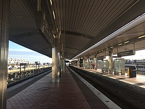
Crystal City station (Washington Metro)
Washington Metro station
Distance: Approx. 299 meters
Latitude and longitude: 38.857856,-77.050874
Crystal City station is an underground Washington Metro station in the Crystal City neighborhood of Arlington County, Virginia. The station opened on July 1, 1977, and serves the Blue Line and Yellow Line services, with a Metroway bus rapid transit stop on the surface.
Ronald Reagan Washington National Airport station
Washington Metro station
Distance: Approx. 529 meters
Latitude and longitude: 38.852985,-77.0439
Ronald Reagan Washington National Airport station is a Washington Metro station in Arlington, Virginia on the Blue and Yellow Lines. The station platform is elevated and covered and is the last above-ground station on the Yellow Line in Virginia, heading into Washington, D.C. It is one of only two stations in the system to have three tracks (the other being West Falls Church). The station is located across Smith Boulevard from Terminal 2 at Ronald Reagan Washington National Airport; the mezzanine is directly connected to Level 2 of the terminal (security checkpoints/gates level) by two pedestrian bridges.

Crystal City station (VRE)
Commuter rail station in Crystal City, Virginia
Distance: Approx. 432 meters
Latitude and longitude: 38.85944444,-77.04833333
Crystal City station is a commuter rail station in the Crystal City section of Arlington County, Virginia, located near the George Washington Memorial Parkway and Ronald Reagan Washington National Airport. It is served by the Fredericksburg Line and Manassas Line of the Virginia Railway Express (VRE) system. VRE plans to rebuild the station nearby to accommodate longer trains and increased service.

Abingdon (plantation)
Plantation site in Virginia, United States of America
Distance: Approx. 615 meters
Latitude and longitude: 38.851371,-77.04443938
Abingdon (also known as the Alexander-Custis Plantation) was an 18th- and 19th-century plantation owned by the prominent Alexander, Custis, Stuart, and Hunter families and worked at times by slaves. The plantation's site is now located in Arlington County in the U.S. state of Virginia. Abingdon is known as the birthplace of Eleanor "Nelly" Parke Custis Lewis (March 31, 1779 – July 15, 1852), a granddaughter of Martha Washington and a step-granddaughter of United States President George Washington.
Synetic Theater
Physical theater company in Arlington, Virginia
Distance: Approx. 146 meters
Latitude and longitude: 38.856857,-77.049485
Synetic Theater is a non-profit physical theater company located in the Washington metropolitan area. It performs at the Crystal City Theatre in Crystal City in Arlington County, Virginia. Since its founding in 2001, its productions have received numerous awards.

PBS
American public television network
Distance: Approx. 732 meters
Latitude and longitude: 38.8621,-77.0503
The Public Broadcasting Service (PBS) is an American public broadcaster and non-commercial, free-to-air television network based in Arlington, Virginia. PBS is a publicly funded nonprofit organization and the most prominent provider of educational programs to public television stations in the United States, distributing shows such as Frontline, Nova, PBS News Hour, Masterpiece, Sesame Street, and This Old House. PBS is funded by a combination of member station dues, the Corporation for Public Broadcasting, pledge drives, and donations from both private foundations and individual citizens.

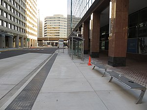
27th & Crystal station
Distance: Approx. 810 meters
Latitude and longitude: 38.848557,-77.051368
27th & Crystal is a bus rapid transit station in Arlington County, Virginia, located near the intersection of 27th Street South and Crystal Drive. The stop is along the Metroway bus rapid transit line, in a portion of the dedicated bus-only highway. It provides two-way service to southern Crystal City.
26th & Clark station
Distance: Approx. 583 meters
Latitude and longitude: 38.85083,-77.051781
26th & Clark is a bus rapid transit station in Arlington County, Virginia, located near the intersection of 23rd Street South and South Clark Street. The stop is on a mixed-traffic segment of the Metroway that is restricted to buses during certain hours. It provides southbound service to central Crystal City.

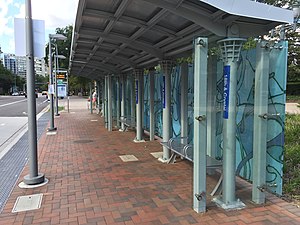
23rd & Crystal station
Distance: Approx. 313 meters
Latitude and longitude: 38.852822,-77.049576
23rd & Crystal is a northbound-only bus rapid transit station in Arlington County, Virginia, located near the intersection of 23rd Street South and Crystal Drive. The stop is on a mixed-traffic segment of the Metroway that is restricted to buses during certain hours. It provides northbound service to central Crystal City.
18th & Crystal station
Distance: Approx. 210 meters
Latitude and longitude: 38.857484,-77.049142
18th & Crystal is a northbound-only bus rapid transit station in Arlington County, Virginia, located near the intersection of 18th Street South and Crystal Drive. The stop is on a mixed-traffic segment of the Metroway that is restricted to buses during certain hours. It provides service along the route to northern Crystal City.

23rd & Clark station
Distance: Approx. 341 meters
Latitude and longitude: 38.853771,-77.052156
23rd & Clark is a bus rapid transit station in Arlington County, Virginia, located near the intersection of 23rd Street South and South Clark Street. The stop is on a mixed-traffic segment of the Metroway that is restricted to buses during certain hours. It provides southbound service to central Crystal City.
Weather in this IP's area
broken clouds
24 Celsius
24 Celsius
23 Celsius
25 Celsius
1022 hPa
67 %
1022 hPa
1021 hPa
10000 meters
4.63 m/s
50 degree
75 %
06:50:59
19:14:58