Country:
Region:
City:
Latitude and Longitude:
Time Zone:
Postal Code:
IP information under different IP Channel
ip-api
Country
Region
City
ASN
Time Zone
ISP
Blacklist
Proxy
Latitude
Longitude
Postal
Route
Luminati
Country
Region
on
City
hanover
ASN
Time Zone
America/Toronto
ISP
WIGHT-AS
Latitude
Longitude
Postal
IPinfo
Country
Region
City
ASN
Time Zone
ISP
Blacklist
Proxy
Latitude
Longitude
Postal
Route
db-ip
Country
Region
City
ASN
Time Zone
ISP
Blacklist
Proxy
Latitude
Longitude
Postal
Route
ipdata
Country
Region
City
ASN
Time Zone
ISP
Blacklist
Proxy
Latitude
Longitude
Postal
Route
Popular places and events near this IP address

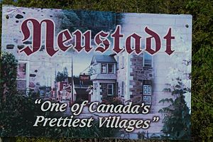
Neustadt, Ontario
Unincorporated community in Ontario, Canada
Distance: Approx. 8308 meters
Latitude and longitude: 44.08,-81
Neustadt is a community in the municipality of West Grey in Grey County in southern Ontario, Canada. The village is located south of Hanover on Grey Road 10 and north of Guelph, Ontario, and Kitchener, Ontario. Neustadt is a rural Ontario village with German roots and a village history associated with farming culture.

Hanover, Ontario
Town in Ontario, Canada
Distance: Approx. 1347 meters
Latitude and longitude: 44.15444444,-81.02333333
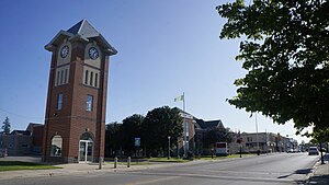
Hanover is a town in the Canadian province of Ontario with a population of about 7,967 residents. It is located in southwestern Grey County, bordering on Bruce County, west of Durham and east of Walkerton on Grey/Bruce Road 4. Hanover has a town hall, police department and the Hanover and District Hospital.
Allan Park, Ontario
Distance: Approx. 8720 meters
Latitude and longitude: 44.16694444,-80.93222222
Allan Park, in the Municipality of West Grey, Grey County, Ontario, Canada is the site of Telesat Canada's Allan Park Earth Station. Allan Park is located on Grey County Road 4 between Durham to the east and Hanover to the west, and north of Ayton. Camp Creek, a tributary of the Saugeen River, flows through the settlement.
Hanover Saugeen Airport
Airport in Ontario, Canada
Distance: Approx. 2203 meters
Latitude and longitude: 44.15805556,-81.06333333
Hanover Saugeen Airport (ICAO: CYHS) is located 1.6 nautical miles (3.0 km; 1.8 mi) west northwest of Hanover, Ontario, Canada. The airport is classified as an airport of entry by Nav Canada and is staffed by the Canada Border Services Agency (CBSA). CBSA officers at this airport can handle general aviation aircraft only, with no more than 15 passengers.

CFBW-FM
Community Radio Station in Walkerton, Ontario
Distance: Approx. 1083 meters
Latitude and longitude: 44.14194444,-81.02972222
CFBW-FM is a Community Radio station broadcasting at 91.3 FM in Walkerton, Ontario, Canada. The station was originally granted a three-year developmental community radio license, and began broadcasting at 91.3 MHz (channel 217LP), with an effective radiated power of 5 watts on December 31, 2001. It was subsequently granted a permanent license in 2005 at 91.3 MHz (channel 217A1) with 250 watts.
Lake Rosalind (Ontario)
Distance: Approx. 2857 meters
Latitude and longitude: 44.1736,-81.0501
Lake Rosalind is a small inland lake located in Bruce County, Ontario, Canada between the towns of Hanover and Walkerton. Lake Rosalind and the interconnected Marl Lake to its south are manmade lakes that were created by the excavation of marl for local cement plants in the early 1900s and the construction of dams later in 1939 and 1946. Both lakes are relatively shallow and small in area (38 hectares and 14 hectares, respectively).
Beatty Saugeen River
River in Ontario, Canada
Distance: Approx. 1943 meters
Latitude and longitude: 44.13444444,-81.02583333
The Beatty Saugeen River is a river in the Saugeen River and Lake Huron drainage basins in Grey County, southwestern Ontario, Canada. It is a tributary of the South Saugeen River.
Maple Hill, Bruce County, Ontario
Dispersed rural community in Ontario, Canada
Distance: Approx. 3214 meters
Latitude and longitude: 44.14472222,-81.07833333
Maple Hill is an dispersed rural community in the township municipality of Brockton, Bruce County, Ontario, Canada. The settlement is located on Grey/Bruce Road 4, between Walkerton and Hanover. The Saugeen River flows south of Maple Hill, and Ruhl Creek, a tributary of the Saugeen, flows east of the community.

John Diefenbaker Senior School
Secondary school in Hanover, Ontario, Canada
Distance: Approx. 592 meters
Latitude and longitude: 44.14785,-81.03147
John Diefenbaker Senior School is a secondary school located in Hanover, Ontario, Canada. It is named after John Diefenbaker, a Prime Minister who was born in Neustadt. The school is part of the Bluewater District School Board.
Allan Park Aerodrome
Airport in Allan Park, Ontario
Distance: Approx. 7744 meters
Latitude and longitude: 44.17972222,-80.95138889
Allan Park Aerodrome (TC LID: CAP2) is located 1.3 nautical miles (2.4 km; 1.5 mi) northeast of Allan Park, Ontario, Canada.
Ruhl Creek
River in Ontario, Canada
Distance: Approx. 2909 meters
Latitude and longitude: 44.14083333,-81.07305556
Ruhl Creek (French: ruisseau Ruhl) is a stream in the township municipality of Brockton, Bruce County in Southwestern Ontario, Canada. It is in the Lake Huron drainage basin and is a right tributary of the Saugeen River.
Ruhl Lake
Lake in Ontario, Canada
Distance: Approx. 3312 meters
Latitude and longitude: 44.17083333,-81.06722222
Ruhl Lake (French: lac Ruhl) is a lake in the township municipality of Brockton, Bruce County in Southwestern Ontario, Canada. It is in the Lake Huron drainage basin and is the source of Ruhl Creek. The lake has an area of 2.97 hectares (7.3 acres) and lies at an elevation of 277 metres (909 ft).
Weather in this IP's area
overcast clouds
8 Celsius
7 Celsius
8 Celsius
8 Celsius
1015 hPa
54 %
1015 hPa
981 hPa
10000 meters
1.79 m/s
4.47 m/s
123 degree
100 %
07:18:59
16:58:35
