Country:
 USA
USARegion:
City:
Latitude and Longitude:
Time Zone:
Postal Code:
IP information under different IP Channel
ip-api
Country
Region
City
ASN
Time Zone
ISP
Blacklist
Proxy
Latitude
Longitude
Postal
Route
IPinfo
Country
Region
City
ASN
Time Zone
ISP
Blacklist
Proxy
Latitude
Longitude
Postal
Route
MaxMind
Country
Region
City
ASN
Time Zone
ISP
Blacklist
Proxy
Latitude
Longitude
Postal
Route
Luminati
Country
USRegion
nc
City
brevard
ASN
Time Zone
America/New_York
ISP
ROCK-HILL-TELEPHONE
Latitude
Longitude
Postal
db-ip
Country
Region
City
ASN
Time Zone
ISP
Blacklist
Proxy
Latitude
Longitude
Postal
Route
ipdata
Country
Region
City
ASN
Time Zone
ISP
Blacklist
Proxy
Latitude
Longitude
Postal
Route
Popular places and events near this IP address

St. Philip's Episcopal Church (Brevard, North Carolina)
Historic church in North Carolina, United States
Distance: Approx. 1627 meters
Latitude and longitude: 35.23166667,-82.73083333
St. Philip's Episcopal Church is a historic Episcopal church located at 256 E. Main Street in Brevard, Transylvania County, North Carolina. It was designed by architect Louis Humbert Asbury and built in 1926.
The Transylvania Times
Distance: Approx. 1611 meters
Latitude and longitude: 35.234434,-82.73419
The Transylvania Times is an American, English language bi-weekly newspaper in Transylvania County, North Carolina, in the United States, and its surrounding area. The paper was founded in 1887, and was family-owned and operated until it was sold to Community Newspaper Holdings in 2021. It provides news coverage for Brevard, Pisgah Forest, Rosman and Lake Toxaway, as well as the townships of Cathey's Creek, Dunn's Rock, Eastatoe, Gloucester, Hogback and Little River.

Transylvania County Courthouse
United States historic place
Distance: Approx. 1577 meters
Latitude and longitude: 35.23361111,-82.73361111
Transylvania County Courthouse is a historic courthouse building located at Brevard, Transylvania County, North Carolina. It was built in 1873, and is a two-story, "T"-plan Italianate style brick building with a hipped roof. It has a rear addition built in the early-20th century.

William Breese Jr. House
Historic house in North Carolina, United States
Distance: Approx. 1642 meters
Latitude and longitude: 35.23277778,-82.73166667
William Breese Jr. House, also known as the Colonial Inn and the Inn at Brevard, is a historic home located at Brevard, Transylvania County, North Carolina. It was built about 1902, and is a two-story, Classical Revival style frame dwelling with a pebbledash finish and hipped roof.

Max and Claire Brombacher House
Historic house in North Carolina, United States
Distance: Approx. 1573 meters
Latitude and longitude: 35.22539,-82.72838806
Max and Claire Brombacher House, also known as Hemlock Hill, is a historic home located at Brevard, Transylvania County, North Carolina. It was built in 1940, and is a one-story, rectangular, Rustic style stone dwelling. It has a pyramidal roof over the south block and a side-gable over the north wing.

Godfrey-Barnette House
Historic house in North Carolina, United States
Distance: Approx. 833 meters
Latitude and longitude: 35.22694444,-82.7375
Godfrey-Barnette House is a historic home located at Brevard, Transylvania County, North Carolina. It was built about 1918, and is a 2+1⁄2-story, five-bay, English Manorial Revival style stone dwelling with a modified T-plan. It has a clipped gable roof, porch, and sun room.

Royal and Louise Morrow House
Historic house in North Carolina, United States
Distance: Approx. 1655 meters
Latitude and longitude: 35.22666667,-82.72777778
Royal and Louise Morrow House, also known as Stone Cottage, is a historic home located at Brevard, Transylvania County, North Carolina. It was built in 1915, and is a 1+1⁄2-story, Bungalow / American Craftsman style stone dwelling. It has a steep, side-gable roof and three-bay wall dormers.
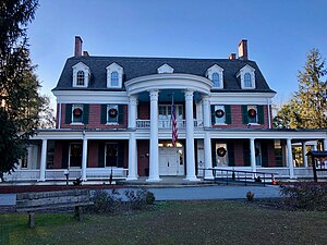
Silvermont (Brevard, North Carolina)
Historic house in North Carolina, United States
Distance: Approx. 1564 meters
Latitude and longitude: 35.22888889,-82.72972222
Silvermont is a historic home located at Brevard, Transylvania County, North Carolina. It was built in 1916–1917, and is a two-story, five-bay, Colonial Revival style brick dwelling with a gambrel roof. Also on the property is a one-story, stone veneer cottage.

Main Street Historic District (Brevard, North Carolina)
Historic district in North Carolina, United States
Distance: Approx. 1480 meters
Latitude and longitude: 35.23305556,-82.73444444
Main Street Historic District is a national historic district located at Brevard, Transylvania County, North Carolina. It encompasses 32 contributing buildings in the central business district of Brevard. The district developed between about 1874 and 1952 and includes notable examples of Early Commercial, Second Empire, and Classical Revival style architecture.

East Main Street Historic District (Brevard, North Carolina)
Historic district in North Carolina, United States
Distance: Approx. 1491 meters
Latitude and longitude: 35.23472222,-82.73694444
East Main Street Historic District is a national historic district located at Brevard, Transylvania County, North Carolina. It encompasses 14 contributing buildings, 1 contributing structure, and 1 contributing site in a predominantly residential section of Brevard. The district developed between about 1900 and 1959 and includes notable examples of Colonial Revival and Bungalow / American Craftsman style architecture.

McMinn Building
United States historic place
Distance: Approx. 1549 meters
Latitude and longitude: 35.23388889,-82.73444444
McMinn Building is a historic commercial building located at Brevard, Transylvania County, North Carolina. It was built in 1899, and is a two-story, rectangular brick building with robust decorative brickwork in the Italianate style. It has three storefronts on the first floor, and offices on the second arranged in a U-shaped plan.
Brevard High School
American public school in North Carolina
Distance: Approx. 1172 meters
Latitude and longitude: 35.2172,-82.735
Brevard High School is a public high school in Brevard, North Carolina, one of three along with Rosman High School and Davidson River School in the Transylvania County Schools district. The highschool has experienced a slight incline in student population going from 723 in 2012–2013 to around 770 in the 2017–2018 school year. The school was located on South Broad Street from 1925 until the 1959–60 school year, when the campus on Country Club Road opened.
Weather in this IP's area
clear sky
17 Celsius
17 Celsius
15 Celsius
19 Celsius
1023 hPa
63 %
1023 hPa
949 hPa
10000 meters
0.45 m/s
2.68 m/s
155 degree
07:33:58
19:00:52