67.55.192.162 - IP Lookup: Free IP Address Lookup, Postal Code Lookup, IP Location Lookup, IP ASN, Public IP
Country:
 USA
USARegion:
City:
Location:
Time Zone:
Postal Code:
ISP:
ASN:
language:
User-Agent:
Proxy IP:
Blacklist:
IP information under different IP Channel
ip-api
Country
Region
City
ASN
Time Zone
ISP
Blacklist
Proxy
Latitude
Longitude
Postal
Route
db-ip
Country
Region
City
ASN
Time Zone
ISP
Blacklist
Proxy
Latitude
Longitude
Postal
Route
IPinfo
Country
Region
City
ASN
Time Zone
ISP
Blacklist
Proxy
Latitude
Longitude
Postal
Route
IP2Location
67.55.192.162Country
usRegion
iowa
City
north liberty
Time Zone
America/Chicago
ISP
Language
User-Agent
Latitude
Longitude
Postal
ipdata
Country
Region
City
ASN
Time Zone
ISP
Blacklist
Proxy
Latitude
Longitude
Postal
Route
Popular places and events near this IP address

Coralville, Iowa
City in Iowa, United States
Distance: Approx. 6207 meters
Latitude and longitude: 41.68833333,-91.58666667
Coralville is a city in Johnson County, Iowa, United States. It is a suburb of Iowa City and part of the Iowa City Metropolitan Statistical Area. The population was 22,318 at the 2020 census.

North Liberty, Iowa
City in Iowa, United States
Distance: Approx. 530 meters
Latitude and longitude: 41.74305556,-91.60777778
North Liberty is a city in Johnson County, Iowa, United States. It is a suburb of Iowa City and part of the Iowa City Metropolitan Statistical Area. As of the 2020 census, the city population was 20,479.
Oakdale, Iowa
Unincorporated community in Iowa, United States
Distance: Approx. 4078 meters
Latitude and longitude: 41.70638889,-91.60305556
Oakdale was an unincorporated rural residential village established in 1908 by the State of Iowa as a statewide treatment center for tuberculosis (TB) in rural Johnson County, located about five miles northwest of central Iowa City and now a part of Coralville, immediately adjacent to the community of North Liberty. The site was chosen for its remoteness, its location along a railroad, and its proximity to University of Iowa Hospitals and Clinics in Iowa City. As a partially self-sustaining community, Oakdale included a depot on the Cedar Rapids and Iowa City Railway (CRandIC) line, power plant, several residential patient and staff buildings, pharmacy, postal and administrative units, as well as associated facilities to support varied farming operations intended to help sustain the institution, including a large dairy.

Iowa Medical and Classification Center
Distance: Approx. 3415 meters
Latitude and longitude: 41.713,-91.61
The Iowa Medical and Classification Center (IMCC) is a medium security correctional facility located in the Johnson County community Oakdale in Coralville, Iowa. It currently houses about 900 inmates. The main role of the IMCC is to serve as a reception and classification center for adults being sent to prison.
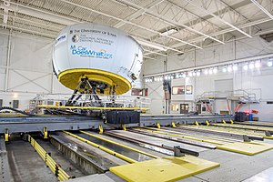
University of Iowa Driving Safety Research Institute
Distance: Approx. 3896 meters
Latitude and longitude: 41.708,-91.6017
The Driving Safety Research Institute (DSRI) at the University of Iowa College of Engineering houses the National Advanced Driving Simulator (NADS-1) and a fleet of instrumented on-road research vehicles. The NADS-1 is one of the largest ground vehicle driving simulators in the world. The National Highway Traffic Safety Administration (NHTSA) owns the NADS-1 simulator, while the University of Iowa takes responsibility for operation and maintenance.

Coralville Lake
Reservoir in Iowa, U.S.
Distance: Approx. 6303 meters
Latitude and longitude: 41.72444444,-91.52972222
Coralville Lake is an artificial lake in Johnson County, Iowa, United States, formed by the Coralville Dam, a dam built from 1949 to 1958 on the Iowa River upstream from the city of Coralville, Iowa.
Madison Township, Johnson County, Iowa
Township in Johnson County, Iowa, U.S.
Distance: Approx. 6325 meters
Latitude and longitude: 41.7686,-91.6694
Madison Township is a township in Johnson County, Iowa, United States.
Penn Township, Johnson County, Iowa
Township in Johnson County, Iowa, U.S.
Distance: Approx. 1827 meters
Latitude and longitude: 41.7431,-91.5794
Penn Township is a township in Johnson County, Iowa, United States.

Liberty High School (Iowa)
Public secondary school in North Liberty, Iowa, United States
Distance: Approx. 2813 meters
Latitude and longitude: 41.7354,-91.5691
Liberty High School is a public high school in North Liberty, Iowa, located within the Iowa City Community School District (ICCSD). It opened in August 2017. Liberty is the third comprehensive high school in ICCSD and covers the entirety of North Liberty and northern Coralville.

H.A. White General Store and House
Historic house in Iowa, United States
Distance: Approx. 684 meters
Latitude and longitude: 41.74869444,-91.59830556
H.A. White General Store and House is a historic building located in North Liberty, Iowa, United States. The central portion of the two-story frame building was completed in 1876. At least three additions were built onto the original in subsequent years.

Old State Quarry State Preserve
United States historic place
Distance: Approx. 3436 meters
Latitude and longitude: 41.76333333,-91.57027778
The Old State Quarry State Preserve, also known as the North Bend Quarries, Capitol Quarry, Old Capitol Quarry, and the State Quarry, is a historic site located northeast of North Liberty, Iowa, United States. The quarry, originally known as North Bend Quarries, began operations in 1842. It provided limestone for numerous buildings and structures in Iowa City and elsewhere in the state.

Samuel and Emma A. Ranshaw House
Historic house in Iowa, United States
Distance: Approx. 1010 meters
Latitude and longitude: 41.75138889,-91.60602778
The Samuel and Emma A. Ranshaw House is a historic building in North Liberty, Iowa, United States. At the time this house was built in 1908, North Liberty was a small and prosperous farming community. The Ranshaws engaged Iowa City architect-builder Bernard Wickham to design and construct this transitional Free Classic subtype of the Queen Anne style.
Weather in this IP's area
snow
-10 Celsius
-17 Celsius
-10 Celsius
-9 Celsius
1021 hPa
84 %
1021 hPa
991 hPa
2414 meters
6.17 m/s
30 degree
100 %