67.23.53.214 - IP Lookup: Free IP Address Lookup, Postal Code Lookup, IP Location Lookup, IP ASN, Public IP
Country:
Region:
City:
Location:
Time Zone:
Postal Code:
ISP:
ASN:
language:
User-Agent:
Proxy IP:
Blacklist:
IP information under different IP Channel
ip-api
Country
Region
City
ASN
Time Zone
ISP
Blacklist
Proxy
Latitude
Longitude
Postal
Route
db-ip
Country
Region
City
ASN
Time Zone
ISP
Blacklist
Proxy
Latitude
Longitude
Postal
Route
IPinfo
Country
Region
City
ASN
Time Zone
ISP
Blacklist
Proxy
Latitude
Longitude
Postal
Route
IP2Location
67.23.53.214Country
Region
arizona
City
phoenix
Time Zone
America/Phoenix
ISP
Language
User-Agent
Latitude
Longitude
Postal
ipdata
Country
Region
City
ASN
Time Zone
ISP
Blacklist
Proxy
Latitude
Longitude
Postal
Route
Popular places and events near this IP address

Roman Catholic Diocese of Phoenix
Latin Catholic jurisdiction in Arizona, United States
Distance: Approx. 287 meters
Latitude and longitude: 33.45,-112.06666667
The Diocese of Phoenix (Latin: Dioecesis Phoenicensis; Spanish: Diócesis de Phoenix) is a Latin Church ecclesiastical territory, or diocese, in western and central Arizona in the United States. It is a suffragan diocese of the ecclesiastical province of the Archdiocese of Santa Fe. The Diocese of Phoenix was established on December 2, 1969.

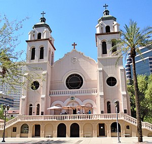
St. Mary's Basilica (Phoenix)
Historic Catholic church in Arizona, United States
Distance: Approx. 168 meters
Latitude and longitude: 33.4507,-112.0694
St. Mary's Basilica – officially The Church of the Immaculate Conception of the Blessed Virgin Mary – is a church of the Diocese of Phoenix located at 231 North 3rd Street at the corner of East Monroe Street in downtown Phoenix, Arizona. It was previously known as St.

Phoenix Symphony Hall
Performing arts venue
Distance: Approx. 94 meters
Latitude and longitude: 33.44886111,-112.070525
Symphony Hall is a multi-purpose performing arts venue, located at 75 North 2nd Street between North 3rd Street and East Washington Street in downtown Phoenix, Arizona. Part of Phoenix Civic Plaza, the hall is bounded to the north by the West Building of the Phoenix Convention Center. The Hall is the home of the Phoenix Symphony, Arizona Opera, and Ballet Arizona, and the site of numerous other performances.
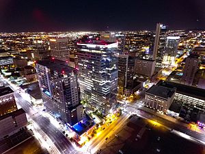
Bank of America Tower (Phoenix)
Highrise multi-use building
Distance: Approx. 163 meters
Latitude and longitude: 33.4479,-112.0704
The Bank of America Tower is a highrise in downtown Phoenix, Arizona. The tower is the centerpiece of the Collier Center, a multi-use office and entertainment complex. The tower was completed in 2000 and serves as the state headquarters for Bank of America.

Arizona Science Center
Science museum in Phoenix, Arizona
Distance: Approx. 286 meters
Latitude and longitude: 33.4486469,-112.0665931
The Arizona Science Center, at 600 Washington St in Downtown Phoenix, Arizona, is a science museum located in Heritage and Science Park. It was founded in 1984 as the Arizona Museum of Science & Technology in a downtown storefront. Its current building, designed by Antoine Predock, was completed in 1997.
Phoenix Convention Center
Events venue in Arizona
Distance: Approx. 41 meters
Latitude and longitude: 33.44934722,-112.06919444
The Phoenix Convention Center is an events venue in downtown Phoenix, Arizona located along East Monroe, East Washington, East Jefferson, North Second, North Third, and North Fifth Streets. The center opened in 1972, and has since hosted national and regional conventions, trade shows, consumer events, musical concerts and theatrical productions. The convention center has three buildings; its north and west Buildings are connected underground by a shared exhibit hall and by a skyway bridge over North Third Street, and its South Building is a stand-alone facility.

3rd Street/Jefferson and 3rd Street/Washington stations
Valley Metro Rail station in Phoenix, Arizona
Distance: Approx. 222 meters
Latitude and longitude: 33.44722222,-112.06993056
3rd Street/Jefferson station and 3rd Street/Washington station, collectively known as Convention Center/Ballpark/Arena, are a pair of light rail stations on Valley Metro Rail in Phoenix, Arizona, United States. They are the fifteenth stop westbound and the fourteenth stop eastbound on the initial 20-mile (32 km) rail segment. The station has two platforms, the westbound platform which is located on 3rd Street and Washington Street, and the eastbound platform on 3rd Street and Jefferson Street, approximately 500 feet (150 m) apart.

Herberger Theater Center
Indoor performing arts venue in Phoenix, Arizona
Distance: Approx. 233 meters
Latitude and longitude: 33.451073,-112.070731
Herberger Theater Center is an indoor performing arts venue featuring three stages in downtown Phoenix, Arizona, whose mission is to support and foster the growth of performing arts in Phoenix as the premier performance venue, arts incubator and advocate. The Herberger Theater Center is not only a performing arts center, but is known in the Phoenix area as a cultivator and advocate for the arts community.

CityScape (Phoenix)
High-rise development in Phoenix, Arizona
Distance: Approx. 340 meters
Latitude and longitude: 33.44791667,-112.07291667
CityScape Phoenix is a high-rise mixed-use development in Downtown Phoenix consisting of residential, retail, office, and hotel components. The development covers three city blocks in the heart of Downtown Phoenix and is located between First Avenue and First Street to the west and east, and between Washington and Jefferson streets to the north and south. A portion of the development was built on the land formerly occupied by Patriots Square Park through a redevelopment agreement with the City of Phoenix.

Saboten Con
Anime convention in Phoenix
Distance: Approx. 318 meters
Latitude and longitude: 33.45194444,-112.07055556
Saboten Con is an annual four-day anime convention held during August/September at the Sheraton Phoenix Downtown in Phoenix, Arizona. The convention is held over Labor Day weekend. Its name comes from the Japanese word saboten, meaning "cactus".
Timeline of Phoenix, Arizona
Distance: Approx. 287 meters
Latitude and longitude: 33.45,-112.066667
The following is a timeline of the history of the city of Phoenix, Arizona, United States.

One North Central
High-rise in Phoenix, Arizona
Distance: Approx. 341 meters
Latitude and longitude: 33.4486,-112.0732
One North Central, formerly the Phelps Dodge Tower, is a high-rise office building located along Central Avenue in the Downtown area of Phoenix, Arizona, United States. Its name is a reference to its street address at 1 N. Central Avenue. The tower rises 20 floors and 290 feet (88 m) in height.
Weather in this IP's area
broken clouds
11 Celsius
9 Celsius
9 Celsius
12 Celsius
1018 hPa
43 %
1018 hPa
975 hPa
10000 meters
0.45 m/s
0.89 m/s
268 degree
71 %
