67.220.104.66 - IP Lookup: Free IP Address Lookup, Postal Code Lookup, IP Location Lookup, IP ASN, Public IP
Country:
Region:
City:
Location:
Time Zone:
Postal Code:
IP information under different IP Channel
ip-api
Country
Region
City
ASN
Time Zone
ISP
Blacklist
Proxy
Latitude
Longitude
Postal
Route
Luminati
Country
Region
ga
City
atlanta
ASN
Time Zone
America/New_York
ISP
QTS-SUW1-ATL1
Latitude
Longitude
Postal
IPinfo
Country
Region
City
ASN
Time Zone
ISP
Blacklist
Proxy
Latitude
Longitude
Postal
Route
IP2Location
67.220.104.66Country
Region
georgia
City
suwanee
Time Zone
America/New_York
ISP
Language
User-Agent
Latitude
Longitude
Postal
db-ip
Country
Region
City
ASN
Time Zone
ISP
Blacklist
Proxy
Latitude
Longitude
Postal
Route
ipdata
Country
Region
City
ASN
Time Zone
ISP
Blacklist
Proxy
Latitude
Longitude
Postal
Route
Popular places and events near this IP address

Gwinnett County, Georgia
County in Georgia, United States
Distance: Approx. 5800 meters
Latitude and longitude: 33.96,-84.03
Gwinnett County ( gwih-NEHT) is located in the north central portion of the U.S. state of Georgia. It forms part of the Atlanta metropolitan area, being located about 9 miles (14 km) northeast of Atlanta city limits. In 2020, the population was 957,062, making it the second-most populous county in Georgia (after Fulton County).

Gwinnett County Airport
Airport in Lawrenceville, Georgia, United States of America
Distance: Approx. 4978 meters
Latitude and longitude: 33.97805556,-83.9625
Gwinnett County Airport (IATA: LZU, ICAO: KLZU, FAA LID: LZU) at Briscoe Field is a municipal airport located about two miles (3 km) northeast of Lawrenceville, Georgia and about 30 miles northeast of Downtown Atlanta. It is owned and operated by the Gwinnett County, in northeastern metro Atlanta. It has a 6,000-foot (1,800 m) runway, and is 1,061 feet (323 m) above mean sea level (AMSL).
Collins Hill High School
Public high school in Gwinnett County, Georgia, United States.
Distance: Approx. 1888 meters
Latitude and longitude: 34.016478,-84.020523
Collins Hill High School is a public high school in Gwinnett County, near Suwanee, Georgia, United States. The school is operated by Gwinnett County Public Schools. The only school which feeds into it is Creekland Middle School.

Georgia Gwinnett College
Public college in Lawrenceville, Georgia, US
Distance: Approx. 2891 meters
Latitude and longitude: 33.98123333,-84.00283889
Georgia Gwinnett College (Georgia Gwinnett or GGC) is a public, four-year college in Lawrenceville, Georgia. It is a member of the University System of Georgia. Georgia Gwinnett College opened on August 18, 2006.

Coolray Field
Baseball park in Georgia, U.S.
Distance: Approx. 3853 meters
Latitude and longitude: 34.04058333,-83.99238889
Coolray Field (formerly known as Gwinnett Stadium) is a 10,427-seat minor league baseball park in unincorporated Gwinnett County, Georgia (with a mailing address in Lawrenceville). It is the home field of the Gwinnett Stripers, the Triple-A affiliate of the Atlanta Braves.
Gwinnett's Fallen Heroes Memorial
Distance: Approx. 6027 meters
Latitude and longitude: 33.95381,-83.99258
Gwinnett's Fallen Heroes Memorial is located at 75 Langely Drive in Lawrenceville, Georgia, and was dedicated on Memorial Day 2003. It honors Gwinnett County soldiers, police and firefighters who died in the line of duty. The memorial honors roughly 700 people, organized by categories of service.

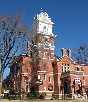
Gwinnett County Courthouse
United States historic place
Distance: Approx. 5777 meters
Latitude and longitude: 33.95666667,-83.98916667
The Gwinnett Historic Courthouse is an historic government building located at 185 West Crogan Street in Lawrenceville in Gwinnett County, Georgia. The original county courthouse burned in 1872. The present day Courthouse was built in 1885.
Fairview Presbyterian Church (Lawrenceville, Georgia)
Church in Georgia, United States of America
Distance: Approx. 4628 meters
Latitude and longitude: 33.96805556,-84.02027778
Fairview Presbyterian Church in Lawrenceville, Georgia, USA, is the state's oldest still-running Presbyterian church, first opening on Sunday, August 10, 1823. The church consists of four distinct areas: a sanctuary, a fellowship hall, a graveyard, and an office/Sunday school worship building. Despite its age, it is well cared for, receiving updates and repairs whenever and wherever they are needed, including but not limited to, pews, security cameras, extra rooms, and a speaker system.

Northside Hospital Gwinnett
Distance: Approx. 4996 meters
Latitude and longitude: 33.963918,-84.01773
Northside Hospital Gwinnett (formerly Gwinnett Medical Center-Lawrenceville) is a hospital with 353 acute care beds in Lawrenceville, Georgia, United States. The hospital was previously the main operation of the overall Gwinnett Medical Center system of hospitals and medical centers serving Gwinnett County, Georgia, until it merged in 2019 with the Northside Hospital system of Atlanta, Georgia. It was renamed at the time of the merger, with Northside Hospital Gwinnett and the other former Gwinnett system facilities being dubbed as Northside Hospital system's "Gwinnett health care campuses".
Phoenix High School (Lawrenceville, Georgia)
Public school in the United States
Distance: Approx. 4885 meters
Latitude and longitude: 33.96333333,-84.005
Phoenix High School is an open-campus public high school in Gwinnett County, Georgia, a suburb north of Atlanta, and a part of the Gwinnett County Public School System, in Lawrenceville, Georgia, United States. Phoenix offers childcare for parents who wish to attend class. The school does not offer extra-curricular activities.

12Stone
Church in GA based with various physical campuses and online., United States
Distance: Approx. 1494 meters
Latitude and longitude: 33.99967,-83.99
12Stone Church (also known simply as "12Stone") is an American Wesleyan multi-site megachurch with multiple locations in Gwinnett County, Georgia. Kevin Myers is the Founding Pastor, having transitioned out of the Senior Pastor role in 2023. Jason Berry currently serves as the Senior Pastor of 12Stone.
William Terrell Homeplace
Historic house in Georgia, United States
Distance: Approx. 5700 meters
Latitude and longitude: 33.966389,-83.966111
The William Terrell Homeplace in Gwinnett County, Georgia near Lawrenceville is a historic site which was listed on the National Register of Historic Places in 1982. It was a two-story Plantation Plain-style plantation house, which in 1982 was the sole house on a 29 acres (12 ha) property. The house was built around 1827.
Weather in this IP's area
mist
0 Celsius
-2 Celsius
-1 Celsius
1 Celsius
1009 hPa
92 %
1009 hPa
970 hPa
6437 meters
2.06 m/s
260 degree
100 %