67.22.218.198 - IP Lookup: Free IP Address Lookup, Postal Code Lookup, IP Location Lookup, IP ASN, Public IP
Country:
Region:
City:
Location:
Time Zone:
Postal Code:
ISP:
ASN:
language:
User-Agent:
Proxy IP:
Blacklist:
IP information under different IP Channel
ip-api
Country
Region
City
ASN
Time Zone
ISP
Blacklist
Proxy
Latitude
Longitude
Postal
Route
db-ip
Country
Region
City
ASN
Time Zone
ISP
Blacklist
Proxy
Latitude
Longitude
Postal
Route
IPinfo
Country
Region
City
ASN
Time Zone
ISP
Blacklist
Proxy
Latitude
Longitude
Postal
Route
IP2Location
67.22.218.198Country
Region
texas
City
wayside
Time Zone
America/Chicago
ISP
Language
User-Agent
Latitude
Longitude
Postal
ipdata
Country
Region
City
ASN
Time Zone
ISP
Blacklist
Proxy
Latitude
Longitude
Postal
Route
Popular places and events near this IP address

Battle of Palo Duro Canyon
Attack on Plains Indians in Texas, US
Distance: Approx. 9354 meters
Latitude and longitude: 34.87777778,-101.60555556
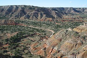
The Battle of Palo Duro Canyon was a military confrontation and a significant United States victory during the Red River War. The battle occurred on September 28, 1874, when several U.S. Army companies under Ranald S. Mackenzie attacked a large encampment of Plains Indians in Palo Duro Canyon in the Texas Panhandle.
Wayside, Armstrong County, Texas
Unincorporated Community in Armstrong County, Texas
Distance: Approx. 2182 meters
Latitude and longitude: 34.79277778,-101.54722222
Wayside is a small unincorporated community in Armstrong County, Texas, United States. It lies at an elevation of 3402 feet (1037 m). In 2000 the population was thirty-five.
Weather in this IP's area
scattered clouds
5 Celsius
2 Celsius
5 Celsius
5 Celsius
1021 hPa
45 %
1021 hPa
904 hPa
10000 meters
3.95 m/s
6.22 m/s
221 degree
45 %