67.22.217.31 - IP Lookup: Free IP Address Lookup, Postal Code Lookup, IP Location Lookup, IP ASN, Public IP
Country:
Region:
City:
Location:
Time Zone:
Postal Code:
ISP:
ASN:
language:
User-Agent:
Proxy IP:
Blacklist:
IP information under different IP Channel
ip-api
Country
Region
City
ASN
Time Zone
ISP
Blacklist
Proxy
Latitude
Longitude
Postal
Route
db-ip
Country
Region
City
ASN
Time Zone
ISP
Blacklist
Proxy
Latitude
Longitude
Postal
Route
IPinfo
Country
Region
City
ASN
Time Zone
ISP
Blacklist
Proxy
Latitude
Longitude
Postal
Route
IP2Location
67.22.217.31Country
Region
texas
City
amarillo
Time Zone
America/Chicago
ISP
Language
User-Agent
Latitude
Longitude
Postal
ipdata
Country
Region
City
ASN
Time Zone
ISP
Blacklist
Proxy
Latitude
Longitude
Postal
Route
Popular places and events near this IP address

Amarillo Civic Center
Convention center in Texas, United States
Distance: Approx. 1441 meters
Latitude and longitude: 35.2090615,-101.8315972
The Amarillo Civic Center is a multi-purpose convention center in Amarillo, Texas. It consists of multiple facilities including: A 2,848-seat auditorium with 2,324 permanent seats used for concerts, Broadway shows and other events. The Cal Farley Coliseum, a 4,987-seat multi-purpose arena serving as home to the Amarillo Wranglers of the North American Hockey League and the Amarillo Dusters of the National Arena League.

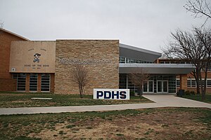
Palo Duro High School
Public school in Amarillo, Texas, United States
Distance: Approx. 811 meters
Latitude and longitude: 35.22675,-101.82454
Palo Duro High School is a school located in the city of Amarillo, Texas, United States, and is one of four high schools in the Amarillo Independent School District. As of the 2016–17 school year, it has 2,075 students. The school was named after Palo Duro Canyon, a canyon system in the Texas Panhandle.

FirstBank Southwest Tower
Building in Amarillo, Texas, United States.
Distance: Approx. 1780 meters
Latitude and longitude: 35.2073,-101.839
FirstBank Southwest Tower is a 374-foot (114 m), 31-story building located in Amarillo, Texas, United States. Formerly known as SPS Tower, Bank One Center, Chase Tower, and Amarillo Tower, it is the tallest building in Amarillo and the West Texas region. The building used to be the home of the Amarillo branch of American National Bank.

Santa Fe Building (Amarillo, Texas)
United States historic place
Distance: Approx. 2034 meters
Latitude and longitude: 35.20444444,-101.8375
The Santa Fe Building is one of the oldest buildings in downtown Amarillo, Texas, U.S.A. It was completed on January 18, 1930 and had the regional offices of the Atchison, Topeka and Santa Fe Railway company. The Amarillo office of the railroad company supervised more than 5,800 miles (9,334 km) of railroads. Brennan Construction Company of Amarillo and Dallas built the building from 1928 to 1930 with an original construction cost of US$1.5 million.

Santa Fe 5000
Preserved American 2-10-4 steam locomotive
Distance: Approx. 1184 meters
Latitude and longitude: 35.2114,-101.830225
Santa Fe No. 5000 is a 2-10-4 "Texas" type steam locomotive constructed by Baldwin Locomotive Works in 1930 for the Atchison, Topeka and Santa Fe Railway. No.

Potter County Courthouse (Texas)
United States historic place
Distance: Approx. 1588 meters
Latitude and longitude: 35.20805556,-101.835
The Potter County Courthouse is a government building for Potter County, located in the county seat of Amarillo, Texas. It was listed on the National Register of Historic Places on August 22, 1996.

J. Marvin Jones Federal Building and Mary Lou Robinson United States Courthouse
United States historic place
Distance: Approx. 1513 meters
Latitude and longitude: 35.20861111,-101.83416667
The J. Marvin Jones Federal Building and Mary Lou Robinson United States Courthouse, formerly known as the Amarillo U.S. Post Office and Courthouse, is a courthouse of the United States District Court for the Northern District of Texas built in Amarillo, Texas in 1937. It reflects Art Deco architecture and Moderne architecture, and was listed on the National Register of Historic Places in 2000. In addition to its continuous use as a courthouse, it has served as a post office, as a customhouse, and as a government office building.

Sacred Heart Cathedral (Amarillo, Texas)
Former cathedral church in Amarillo, Texas, United States
Distance: Approx. 1986 meters
Latitude and longitude: 35.204584,-101.836047
Sacred Heart Cathedral is a former cathedral church located in Amarillo, Texas, United States. It was the seat of the Diocese of Amarillo from 1927 to 1975.
Hodgetown
Baseball stadium in Amarillo, Texas
Distance: Approx. 1806 meters
Latitude and longitude: 35.20577778,-101.83097222
Hodgetown is a baseball park in downtown Amarillo, Texas. It is the home ballpark of the Amarillo Sod Poodles, the Double-A affiliate of the Arizona Diamondbacks in the Texas League. It opened on April 8, 2019, and can seat 6,631 people.

Oliver–Eakle–Barfield Building
Historic building in Amarillo, Texas, U.S.
Distance: Approx. 1705 meters
Latitude and longitude: 35.20753,-101.83746
The Oliver–Eakle–Barfield Building is a historic building located at 600 South Polk Street in Amarillo, Texas. The building was listed on the National Register of Historic Places on January 11, 2019. The building was converted into the Barfield Hotel in 2019.

Herring Hotel (Amarillo, Texas)
United States historic place
Distance: Approx. 1309 meters
Latitude and longitude: 35.21027778,-101.8325
The Herring Hotel is one of the oldest buildings in downtown Amarillo, Texas. It was completed in 1926 and was named after the builder and operator, Cornelius Taylor Herring (1849–1931). The building was added to the National Register of Historic Places on January 25, 2024.
Amarillo Lake
Lake in Texas, United States
Distance: Approx. 1953 meters
Latitude and longitude: 35.21866667,-101.85238889
Amarillo Lake, also known as Wildhorse Lake is a lake located in northern Amarillo, Texas. The reservoir is situated on the south side of Interstate 40 (and the historic Route 66). The city of Amarillo was originally constructed around the lake.
Weather in this IP's area
clear sky
-6 Celsius
-10 Celsius
-7 Celsius
-5 Celsius
1031 hPa
69 %
1031 hPa
900 hPa
10000 meters
2.57 m/s
130 degree