Country:
 USA
USARegion:
City:
Latitude and Longitude:
Time Zone:
Postal Code:
IP information under different IP Channel
ip-api
Country
Region
City
ASN
Time Zone
ISP
Blacklist
Proxy
Latitude
Longitude
Postal
Route
IPinfo
Country
Region
City
ASN
Time Zone
ISP
Blacklist
Proxy
Latitude
Longitude
Postal
Route
MaxMind
Country
Region
City
ASN
Time Zone
ISP
Blacklist
Proxy
Latitude
Longitude
Postal
Route
Luminati
Country
USASN
Time Zone
America/Chicago
ISP
SYNOPTEK
Latitude
Longitude
Postal
db-ip
Country
Region
City
ASN
Time Zone
ISP
Blacklist
Proxy
Latitude
Longitude
Postal
Route
ipdata
Country
Region
City
ASN
Time Zone
ISP
Blacklist
Proxy
Latitude
Longitude
Postal
Route
Popular places and events near this IP address

Utica, New York
City in New York, United States
Distance: Approx. 18 meters
Latitude and longitude: 43.10083333,-75.2325
Utica ( ) is a city in the Mohawk Valley and the county seat of Oneida County, New York, United States. The tenth-most-populous city in New York State, its population was 65,283 in the 2020 U.S. Census. Located on the Mohawk River at the foot of the Adirondack Mountains, it is approximately 95 mi (153 km) west-northwest of Albany, 55 mi (89 km) east of Syracuse and 240 mi (386 km) northwest of New York City.

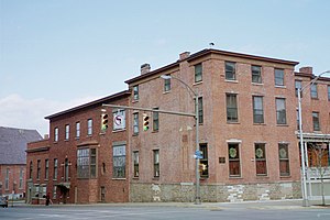
Adirondack Bank Center
Multi-purpose arena in Utica, New York
Distance: Approx. 459 meters
Latitude and longitude: 43.104982,-75.233492
The Adirondack Bank Center at the Utica Memorial Auditorium is a 3,860-seat multi-purpose arena in Utica, New York, with a capacity of 5,700 for concerts. Nicknamed the Aud, it is the home arena of the Utica Comets, the AHL affiliate of the NHL's New Jersey Devils, and Utica City FC of the Major Arena Soccer League. In 2011, the Utica Memorial Auditorium was designated as a National Historic Civil Engineering Landmark by the American Society of Civil Engineers in recognition of its innovative cable suspended roof.

Stanley Theater (Utica, New York)
Theater in Utica, New York, United States
Distance: Approx. 356 meters
Latitude and longitude: 43.09888889,-75.23611111
The Stanley Theatre is a historic Baroque movie palace in Utica, New York. Over the years, it has gone through several changes of ownership, but has always been affiliated with Warner Brothers Pictures.

Union Station (Utica, New York)
Distance: Approx. 523 meters
Latitude and longitude: 43.1041991,-75.2281117
The Boehlert Transportation Center at Union Station is a train station served by Amtrak and the Adirondack Railroad in Utica, New York. It is owned by Oneida County, and named for retired U.S. Rep. Sherwood Boehlert (R-New Hartford).
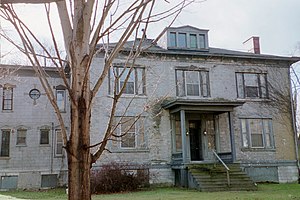
Roscoe Conkling House
Historic house in New York, United States
Distance: Approx. 586 meters
Latitude and longitude: 43.09610833,-75.22972778
The Roscoe Conkling House is a historic house at 3 Rutger Park in Utica, New York, United States. A National Historic Landmark, it was the home of Roscoe Conkling (1829–1888), a powerful and controversial politician. He is responsible, perhaps, for the angry, political atmosphere that led to the assassination of U.S. President James Garfield.
New Century Club (Utica, New York)
United States historic place
Distance: Approx. 247 meters
Latitude and longitude: 43.09944444,-75.235
The New Century Club is located at 253 Genesee Street in Utica, New York. It was added to the National Register of Historic Places in September, 1985. It is architecturally significant for its Greek Revival architecture, once characteristic of this part of the city of Utica.

Grace Church (Utica, New York)
Historic church in New York, United States
Distance: Approx. 107 meters
Latitude and longitude: 43.10083333,-75.23138889
Grace Church is an Episcopal church at 193 Genesee Street in Utica, New York, which was established in 1838.
Fort Schuyler Club
United States historic place
Distance: Approx. 247 meters
Latitude and longitude: 43.09972222,-75.23527778
The Fort Schuyler Club, founded in 1883, is a private members' club located in downtown Utica, New York, USA. Early members of the club included Elihu Root, Francis Kernan, Horatio Seymour, Charlemagne Tower, and Ward Hunt. The club's clubhouse is "significant as a rare and substantially intact example of a late 19th-early 20th century social club" in downtown Utica. The building, built in stages from 1830 on, is a landmark located prominently on Genesee Street, the "principal thoroughfare" of Utica.

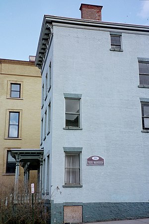
Hotel Utica
Distance: Approx. 245 meters
Latitude and longitude: 43.102624,-75.230829
The Hotel Utica is a historic hotel building in Utica, New York. It was designed by Esenwein & Johnson, an architectural firm from Buffalo, for United Hotels Company of America. The hotel was restored with public funding and reopened in 2001.

Lower Genesee Street Historic District
Historic district in New York, United States
Distance: Approx. 508 meters
Latitude and longitude: 43.10416667,-75.22833333
Lower Genesee Street Historic District is a national historic district located at Utica in Oneida County, New York. The district includes 45 contributing buildings and encompasses a collection of commercial and industrial buildings in the north center of the city. The oldest extant buildings in the city are located here, which includes buildings dating from 1830 to 1929.

Mohawk Valley Health System
Health system in New York State, United States
Distance: Approx. 501 meters
Latitude and longitude: 43.1033425,-75.2378723
Mohawk Valley Health System (MVHS) is a non-profit health system providing services to residents of the Mohawk Valley in Central New York. It was created in 2014 as an affiliation of Faxton St. Luke's Healthcare and St.

Alexander Pirnie Federal Building
United States historic place
Distance: Approx. 486 meters
Latitude and longitude: 43.10388889,-75.22833333
Alexander Pirnie Federal Building is a historic post office, courthouse, and custom house located at Utica, Oneida County, New York. It was named for Congressman Alexander Pirnie in 1984. It was listed on the National Register of Historic Places in 2015.
Weather in this IP's area
clear sky
11 Celsius
10 Celsius
9 Celsius
12 Celsius
1023 hPa
85 %
1023 hPa
1006 hPa
10000 meters
0.45 m/s
0.45 m/s
233 degree
07:03:11
18:34:56