Country:
 USA
USARegion:
City:
Latitude and Longitude:
Time Zone:
Postal Code:
IP information under different IP Channel
ip-api
Country
Region
City
ASN
Time Zone
ISP
Blacklist
Proxy
Latitude
Longitude
Postal
Route
IPinfo
Country
Region
City
ASN
Time Zone
ISP
Blacklist
Proxy
Latitude
Longitude
Postal
Route
MaxMind
Country
Region
City
ASN
Time Zone
ISP
Blacklist
Proxy
Latitude
Longitude
Postal
Route
Luminati
Country
USASN
Time Zone
America/Chicago
ISP
SYNOPTEK
Latitude
Longitude
Postal
db-ip
Country
Region
City
ASN
Time Zone
ISP
Blacklist
Proxy
Latitude
Longitude
Postal
Route
ipdata
Country
Region
City
ASN
Time Zone
ISP
Blacklist
Proxy
Latitude
Longitude
Postal
Route
Popular places and events near this IP address

Beverly Hills, California
Urban City in California, United States
Distance: Approx. 79 meters
Latitude and longitude: 34.07305556,-118.39944444
Beverly Hills is a city located in Los Angeles County, California, United States. A notable and historic suburb of Los Angeles, it is located just southwest of the Hollywood Hills, approximately 12.2 miles (19.6 km) northwest of downtown Los Angeles. Beverly Hills' land area totals 5.71 square miles (14.8 km2) and (together with the neighboring smaller city of West Hollywood to the east) is entirely surrounded by the city of Los Angeles.

Rodeo Drive
Shopping district in Beverly Hills, California
Distance: Approx. 559 meters
Latitude and longitude: 34.06923056,-118.40298889
Rodeo Drive is a two-mile-long (3.2 km) street in Beverly Hills, California, with its southern segment in the City of Los Angeles, known as one of the most expensive streets in the world. Its southern terminus is at Beverwil Drive, and its northern terminus is at its intersection with Sunset Boulevard in Beverly Hills. The name is most commonly used metonymically to refer to the three-block stretch of the street between Wilshire Boulevard and Little Santa Monica Boulevard.

Beverly Hills Post Office
Area of Los Angeles, California
Distance: Approx. 212 meters
Latitude and longitude: 34.07247222,-118.40184722
Beverly Hills Post Office (BHPO) is the name given to a section of Los Angeles, California, that lies within the 90210 ZIP code, assigned to the Beverly Hills Post Office. Los Angeles mailing addresses with the ZIP code 90210 may be written as "Beverly Hills, CA 90210", though the properties themselves lie outside of the Beverly Hills city limits.

Beverly Drive
Roadway in Beverly Hills and Los Angeles, California, U.S.
Distance: Approx. 465 meters
Latitude and longitude: 34.07305556,-118.405
Beverly Drive is a major north–south roadway in Beverly Hills and Los Angeles.

Beverly Gardens Park
Distance: Approx. 344 meters
Latitude and longitude: 34.07222222,-118.40333333
Beverly Gardens Park is a public park in Beverly Hills, California.

Wallis Annenberg Center for the Performing Arts
Distance: Approx. 186 meters
Latitude and longitude: 34.07228,-118.40124
The Wallis Annenberg Center for the Performing Arts is a community arts center in Beverly Hills, California, named for philanthropist Wallis Annenberg
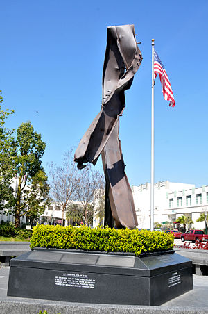
Beverly Hills 9/11 Memorial Garden
Memorial in Beverly Hills, California
Distance: Approx. 156 meters
Latitude and longitude: 34.072253,-118.399532
The Beverly Hills 9/11 Memorial Garden is a memorial space in honor of the victims of the September 11 attacks in Beverly Hills, California at the corner of North Rexford Drive and South Santa Monica Boulevard/Burton Way. Dedicated on September 11, 2011, exactly ten years after the attack, it is centered on a 30-foot bent steel beam salvaged from the wreckage of the World Trade Center. It was entirely funded by private donors.

Rodeo Drive Walk of Style
Distance: Approx. 585 meters
Latitude and longitude: 34.068582,-118.401895
The Rodeo Drive Walk of Style, located on Rodeo Drive in Beverly Hills, California, commemorates people who have made important contributions to fashion, design, and costume.

Beverly Hills City Hall
City hall in Beverly Hills, California
Distance: Approx. 91 meters
Latitude and longitude: 34.0729,-118.4005
The Beverly Hills City Hall is a historic building and city hall in Beverly Hills, California, United States. The building houses the city administration, including the office of the Mayor of Beverly Hills and board meetings of the Beverly Hills City Council. Additionally, it houses the Municipal Gallery, an evolving art space designed by interior designer Gere Kavanaugh.

Luxe Rodeo Drive Hotel
Distance: Approx. 559 meters
Latitude and longitude: 34.06899,-118.40239
The Luxe Rodeo Drive Hotel was a luxury hotel in the City of Beverly Hills, California. It was the only hotel located on Rodeo Drive, the main shopping street in Beverly Hills. It closed in 2020.
Peace and Love (sculpture)
Distance: Approx. 252 meters
Latitude and longitude: 34.07275,-118.40252778
Peace and Love is a public sculpture in Beverly Hills, California. It was designed by Ringo Starr, the former member of The Beatles who resides in Beverly Hills, and it weighs 800 pounds.
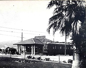
Beverly Hills station
Distance: Approx. 276 meters
Latitude and longitude: 34.072174,-118.402449
Beverly Hills refers to two railway stations in Beverly Hills, California. With the first constructed in 1896, they came to be served by the Pacific Electric and Southern Pacific railroads until the 1960s. The first station was demolished and replaced with a second across the street.
Weather in this IP's area
clear sky
27 Celsius
28 Celsius
21 Celsius
32 Celsius
1013 hPa
50 %
1013 hPa
1004 hPa
10000 meters
4.63 m/s
120 degree
06:51:18
18:32:06