Country:
 USA
USARegion:
City:
Latitude and Longitude:
Time Zone:
Postal Code:
IP information under different IP Channel
ip-api
Country
Region
City
ASN
Time Zone
ISP
Blacklist
Proxy
Latitude
Longitude
Postal
Route
IPinfo
Country
Region
City
ASN
Time Zone
ISP
Blacklist
Proxy
Latitude
Longitude
Postal
Route
MaxMind
Country
Region
City
ASN
Time Zone
ISP
Blacklist
Proxy
Latitude
Longitude
Postal
Route
Luminati
Country
USRegion
vt
City
montpelier
ASN
Time Zone
America/New_York
ISP
TVC-AS1
Latitude
Longitude
Postal
db-ip
Country
Region
City
ASN
Time Zone
ISP
Blacklist
Proxy
Latitude
Longitude
Postal
Route
ipdata
Country
Region
City
ASN
Time Zone
ISP
Blacklist
Proxy
Latitude
Longitude
Postal
Route
Popular places and events near this IP address
Montpelier, Vermont
Capital city of Vermont, United States
Distance: Approx. 665 meters
Latitude and longitude: 44.25944444,-72.57583333
Montpelier ( mont-PEEL-yər) is the capital of the U.S. state of Vermont and the county seat of Washington County. The site of Vermont's state government, it is the least populated state capital in the United States. As of the 2020 census, the population was 8,074, with a daytime population growth of about 21,000 due to the large number of jobs within city limits.

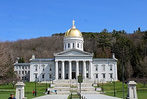
Vermont State House
American state capitol building
Distance: Approx. 463 meters
Latitude and longitude: 44.2625,-72.58055556
The Vermont State House, located in Montpelier, is the state capitol of the U.S. state of Vermont. It is the seat of the Vermont General Assembly. The current Greek Revival structure is the third building on the same site to be used as the State House.

Vermont House of Representatives
Lower house of the Vermont General Assembly
Distance: Approx. 463 meters
Latitude and longitude: 44.2625,-72.58055556
The Vermont House of Representatives is the lower house of the Vermont General Assembly, the state legislature of the U.S. state of Vermont. The House comprises 150 members, with each member representing around 4,100 citizens. Representatives are elected to a two-year term without term limits.
Vermont Supreme Court
Highest court in the U.S. state of Vermont
Distance: Approx. 495 meters
Latitude and longitude: 44.26166,-72.57975
The Vermont Supreme Court is the highest judicial authority of the U.S. state of Vermont. Unlike most other states, the Vermont Supreme Court hears appeals directly from the trial courts, as Vermont has no intermediate appeals court. The Court consists of a chief justice and four associate justices; the Court mostly hears appeals of cases that have been decided by other courts.
Vermont Senate
Upper house of the Vermont General Assembly
Distance: Approx. 500 meters
Latitude and longitude: 44.26222222,-72.58083333
The Vermont Senate is the upper house of the Vermont General Assembly, the state legislature of the U.S. state of Vermont. The senate consists of 30 members elected from multi-member districts. Each senator represents at least 20,300 citizens.

The Pavilion (Vermont)
Principal workplace of the Governor of Vermont
Distance: Approx. 525 meters
Latitude and longitude: 44.2612,-72.5794
The Pavilion is the principal workplace of the governor of Vermont, located at 109 State Street in Montpelier, capital of the U.S. state of Vermont. The building is built in the French Second Empire style, and houses the working offices, reception room, press briefing room, and living apartments of Vermont's governor. The term "The Fifth Floor" is sometimes used as a metonym for a governor's administration, or the Vermont governorship, which refers to the location of the governor's offices on the fifth floor of the Pavilion.
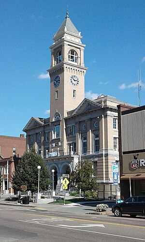
Montpelier City Hall
Distance: Approx. 696 meters
Latitude and longitude: 44.259183,-72.575512
Montpelier City Hall is located in Montpelier, U.S. state of Vermont. The four-story structure opened in 1909.
Vermont Medical Society
American professional organization for physicians
Distance: Approx. 405 meters
Latitude and longitude: 44.2617899,-72.5769966
The Vermont Medical Society is the professional organization for physicians in the U.S. state of Vermont. Founded in 1813, the organization provides service to physicians in the form of information and lobbies the Vermont General Assembly on regulatory issues affecting its membership.

Christ Episcopal Church (Montpelier, Vermont)
Church in Vermont, United States
Distance: Approx. 448 meters
Latitude and longitude: 44.261475,-72.577615
Christ Episcopal Church is a historic church located at 64 State Street in Montpelier, Vermont in the United States. It was founded in 1840. Among its founders was Dr.
Taylor Street Bridge
Distance: Approx. 701 meters
Latitude and longitude: 44.25963,-72.57993
The Taylor Street Bridge is a Parker through truss bridge that crosses the Winooski River in Montpelier, Vermont. It was built in 1929 by the Berlin Construction Company. The bridge is listed on the National Register of Historic Places.

Montpelier Historic District (Vermont)
Historic district in Vermont, United States
Distance: Approx. 449 meters
Latitude and longitude: 44.26138889,-72.57694444
The Montpelier Historic District encompasses much of the historic commercial and government district of Montpelier, the state capital of Vermont. The city center, focused on the confluence of the Winooski River with its North Branch, has been economically driven by state government since 1805, and had industry powered by the rivers. Its center reflects a diversity of 19th century architecture.
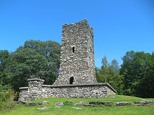
Hubbard Park (Montpelier, Vermont)
Park in Montpelier, Vermont, U.S.
Distance: Approx. 673 meters
Latitude and longitude: 44.2712,-72.5788
Hubbard Park is a 194-acre park (79 ha) located to the north of the Vermont State House in Montpelier, Vermont. The park features approximately 7 miles of hiking and skiing trails, a soccer and ball field, picnic areas, a sledding hill, seven fireplaces, two sheltered pavilions, and a historic 54-foot high observation tower that was built between 1915-1930. The tower was listed on the Vermont State Historic Register on March 15, 1990, and along with its original parcel area, was added to the National Register of Historic Places as part of a Boundary Increase of the Montpelier Historic District (listed as property #562) on February 20, 2018.
Weather in this IP's area
overcast clouds
12 Celsius
12 Celsius
11 Celsius
13 Celsius
1009 hPa
92 %
1009 hPa
989 hPa
10000 meters
2.06 m/s
190 degree
100 %
06:21:57
19:14:02