Country:
Region:
City:
Latitude and Longitude:
Time Zone:
Postal Code:
IP information under different IP Channel
ip-api
Country
Region
City
ASN
Time Zone
ISP
Blacklist
Proxy
Latitude
Longitude
Postal
Route
Luminati
Country
Region
ab
City
stonyplain
ASN
Time Zone
America/Edmonton
ISP
ASN-WIBAND-1
Latitude
Longitude
Postal
IPinfo
Country
Region
City
ASN
Time Zone
ISP
Blacklist
Proxy
Latitude
Longitude
Postal
Route
db-ip
Country
Region
City
ASN
Time Zone
ISP
Blacklist
Proxy
Latitude
Longitude
Postal
Route
ipdata
Country
Region
City
ASN
Time Zone
ISP
Blacklist
Proxy
Latitude
Longitude
Postal
Route
Popular places and events near this IP address

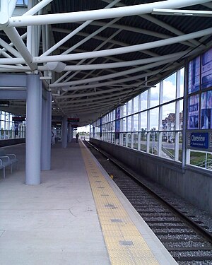
Clareview station
Light rail station in Edmonton, Alberta, Canada
Distance: Approx. 1636 meters
Latitude and longitude: 53.60166667,-113.41138889
Clareview station is an Edmonton LRT station in Edmonton, Alberta, Canada. It serves the Capital Line and is currently the northern terminus of the line. It is a ground-level station located near 42 Street and 139 Avenue, and is named after the northeast Edmonton district of Clareview.

Belvedere station (Edmonton)
Light rail station in Edmonton, Alberta, Canada
Distance: Approx. 3253 meters
Latitude and longitude: 53.58833333,-113.43277778
Belvedere station is an Edmonton LRT in Edmonton, Alberta. It serves the Capital Line. It is a ground-level station located at Fort Road and 129 Avenue.
Newton, Edmonton
Neighbourhood in Edmonton, Alberta, Canada
Distance: Approx. 3503 meters
Latitude and longitude: 53.576,-113.423
Newton is a residential neighbourhood located in north east Edmonton, Alberta, Canada. The neighbourhood is bounded on the south by Alberta (118) Avenue, on the north by the Yellowhead Trail, on the east by 50 Street, and on the west by 58 Street. Northlands Coliseum and the Coliseum LRT station are located a short distance to the west of the neighbourhood.

Edmonton Composting Facility
Municipal site in Canada, 1999 to 2019
Distance: Approx. 3101 meters
Latitude and longitude: 53.59638889,-113.34027778
The Edmonton Composting Facility was the site of the Canadian City of Edmonton's co-composting system for processing organic waste. Co-composting involves mixing household waste with biosolids (sewage sludge), and using microorganisms to break them down into simple compost. Waste was separated from general garbage.

D.L. MacDonald Yard
Distance: Approx. 2245 meters
Latitude and longitude: 53.595,-113.42027778
D.L. MacDonald Yard is the maintenance facility, garage, and operations centre for the Capital and Metro light rail transit lines operated by Edmonton Transit Service, in Edmonton, Alberta, Canada. Located to the northeast in the Kennedale industrial area, at 13310 - 50A Street, the facility opened in December 1983 at a cost of $28.2 million. Expansions to the facility to accommodate additional light rail vehicles were completed as part of the South LRT Extension Project.
Clover Bar Bridge
Bridge in Alberta, Canada
Distance: Approx. 3230 meters
Latitude and longitude: 53.57138889,-113.3725
Clover Bar Bridge and Beverly Bridge are a pair of bridges that span the North Saskatchewan River in the city of Edmonton, Alberta, Canada. The twin spans carry 6 lanes total of Yellowhead Trail, the name given to Alberta Highway 16 within Edmonton city limits. Clover Bar Bridge, the original truss span, was completed in the summer of 1953 and connected Beverly with mostly rural Strathcona County.
Northeast Community Health Centre
Hospital in Edmonton, Alberta, Canada
Distance: Approx. 2075 meters
Latitude and longitude: 53.60416667,-113.41722222
The Northeast Community Health Centre (NECHC) is a community health centre located in Northeast-Edmonton. It provides medical services through Alberta Health Services, including a 24/7 emergency department.

Edmonton-Beverly-Clareview
Provincial electoral district in Alberta, Canada
Distance: Approx. 1114 meters
Latitude and longitude: 53.59,-113.38
Edmonton-Beverly-Clareview is a provincial electoral district for the Legislative Assembly of Alberta, Canada. The electoral district covers the neighbourhoods of Beverly, Belmont Park and Clareview Town Centre. It was created in 1996, and was first contested in the 1997 election.
Clareview, Edmonton
Area in Alberta, Canada
Distance: Approx. 603 meters
Latitude and longitude: 53.6,-113.396
Clareview is a residential area in the northeast portion of the city of Edmonton in Alberta, Canada. It was established in 1972 through Edmonton City Council's adoption of the Clareview Outline Plan, which guides the overall development of the area.
Hermitage, Edmonton
Area in Alberta, Canada
Distance: Approx. 1783 meters
Latitude and longitude: 53.584,-113.396
Hermitage is a residential area in the northeast portion of the City of Edmonton in Alberta, Canada. It was established in 1970 through Edmonton City Council's adoption of the Hermitage General Outline Plan, which guides the overall development of the area. Named after the ca.
Edmonton-Belmont
Defunct provincial electoral district in Alberta, Canada
Distance: Approx. 698 meters
Latitude and longitude: 53.595,-113.395
Edmonton-Belmont was a provincial electoral district in Alberta, Canada, mandated to return a single member to the Legislative Assembly of Alberta using the first past the post method of voting from 1971 to 1993.
Edmonton-Beverly
Defunct provincial electoral district in Alberta, Canada
Distance: Approx. 3408 meters
Latitude and longitude: 53.57,-113.403
Edmonton-Beverly was a provincial electoral district in Alberta, Canada, mandated to return a single member to the Legislative Assembly of Alberta using the first past the post method of voting from 1971 to 1993.
Weather in this IP's area
light snow
1 Celsius
-4 Celsius
0 Celsius
1 Celsius
1017 hPa
94 %
1017 hPa
939 hPa
8047 meters
4.92 m/s
4.92 m/s
301 degree
100 %
07:41:48
16:52:30
