Country:
 USA
USARegion:
City:
Latitude and Longitude:
Time Zone:
Postal Code:
IP information under different IP Channel
ip-api
Country
Region
City
ASN
Time Zone
ISP
Blacklist
Proxy
Latitude
Longitude
Postal
Route
IPinfo
Country
Region
City
ASN
Time Zone
ISP
Blacklist
Proxy
Latitude
Longitude
Postal
Route
MaxMind
Country
Region
City
ASN
Time Zone
ISP
Blacklist
Proxy
Latitude
Longitude
Postal
Route
Luminati
Country
USASN
Time Zone
America/Chicago
ISP
123NET
Latitude
Longitude
Postal
db-ip
Country
Region
City
ASN
Time Zone
ISP
Blacklist
Proxy
Latitude
Longitude
Postal
Route
ipdata
Country
Region
City
ASN
Time Zone
ISP
Blacklist
Proxy
Latitude
Longitude
Postal
Route
Popular places and events near this IP address
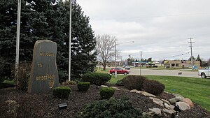
Bridgeport, Michigan
Census-designated place & unincorporated community in Michigan, United States
Distance: Approx. 1682 meters
Latitude and longitude: 43.37055556,-83.88277778
Bridgeport is an unincorporated community and census-designated place (CDP) in Saginaw County in the U.S. state of Michigan. The CDP had a population of 6,571 at the 2020 census. The community is located within Bridgeport Township.

Bridgeport Charter Township, Michigan
Charter township in Michigan, United States
Distance: Approx. 985 meters
Latitude and longitude: 43.36166667,-83.88527778
Bridgeport Charter Township is a charter township of Saginaw County in the U.S. state of Michigan. The population was 10,104 at the 2020 census.
Saginaw High School
American public high school
Distance: Approx. 6905 meters
Latitude and longitude: 43.4064,-83.926
Saginaw High School (formerly part of the Saginaw City School District) was a high school located in Saginaw, Michigan, USA. The student enrollment was 405 at time of closing.
Fort Saginaw Mall
Shopping mall in Michigan, United States
Distance: Approx. 6931 meters
Latitude and longitude: 43.416419,-83.898307
Fort Saginaw Mall was an enclosed shopping mall located in Buena Vista Township, just outside the city of Saginaw, Michigan, United States. Opened in 1966, the mall served as Saginaw's only enclosed mall until Fashion Square Mall opened on the other end of town in 1972. Fort Saginaw Mall had become a dead mall by the 1980s, as many of its stores had closed.
Bridgeport High School (Michigan)
Public high school in Bridgeport, Michigan
Distance: Approx. 485 meters
Latitude and longitude: 43.3553,-83.8697
Bridgeport High School is public institution located at 4961 Bearcat Blvd. in Bridgeport, Michigan. Bridgeport's mascot is a bearcat, and its colors are yellow and red.
Buena Vista School District (Michigan)
US school district
Distance: Approx. 7050 meters
Latitude and longitude: 43.41967,-83.87933
Buena Vista School District was a school district headquartered in Buena Vista Charter Township, Michigan, and part of the Saginaw Intermediate School District (Saginaw ISD). As of July 2013, the school district closed and became a tax-collecting district of the Saginaw ISD to pay the district's outstanding debts.
Bridgeport-Spaulding Community School District
School district in Michigan
Distance: Approx. 527 meters
Latitude and longitude: 43.35687,-83.86902
The Bridgeport-Spaulding Community School District is a school district headquartered in the Educational Services Center in Bridgeport, a community in Bridgeport Charter Township, Michigan. It is a part of the Saginaw Intermediate School District and serves Bridgeport and portions of Buena Vista south of Hess Avenue. In 2013 the Buena Vista School District closed.
Buena Vista High School (Michigan)
Former public high school in Buena Vista Charter Township, Michigan
Distance: Approx. 6686 meters
Latitude and longitude: 43.4164,-83.87916
Buena Vista High School was a public high school located at 3945 East Holland in Buena Vista Charter Township, Michigan and was part of the former Buena Vista School District. The school was closed when the Buena Vista School District was dissolved in July 2013. Buena Vista's mascot was the Knights, and its colors were blue and white.
Schmidt Site
Archaeological site in Michigan, United States
Distance: Approx. 3701 meters
Latitude and longitude: 43.34722222,-83.91944444
The Schmidt Site, also designated 20SA192, is an archaeological site located just south of the Cass River near Bridgeport, Michigan. It was listed on the National Register of Historic Places in 1973.
Bugai Site
Archaeological site in Michigan, United States
Distance: Approx. 2920 meters
Latitude and longitude: 43.33333333,-83.85833333
The Bugai Site, designated 20SA215, is an archaeological site located near Bridgeport, Michigan. It was listed on the National Register of Historic Places in 1982. The site was a burial location dating from the Middle Woodland period.

State Street Bridge (Bridgeport, Michigan)
United States historic place
Distance: Approx. 596 meters
Latitude and longitude: 43.35805556,-83.8825
The State Street Bridge, also known as the Fort Road Bridge or the Bridgeport Bridge, is a bridge carrying State Street (Fort Road) over the Cass River in Bridgeport, Michigan, United States. It was listed on the National Register of Historic Places in 1995.
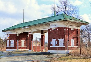
Saginaw County Fairgrounds Main Gate
United States historic place
Distance: Approx. 6588 meters
Latitude and longitude: 43.40722222,-83.91722222
The Saginaw County Fairgrounds Main Gate is the entry gate to the former Saginaw County Fairgrounds, located at 2701 East Genesee Avenue in Saginaw, Michigan. It was listed on the National Register of Historic Places in 2014.
Weather in this IP's area
clear sky
7 Celsius
5 Celsius
4 Celsius
9 Celsius
1032 hPa
72 %
1032 hPa
1010 hPa
10000 meters
3.09 m/s
190 degree
07:54:41
18:45:43